
The Waterfront Space Planning of Urban Historical River based on
Cultural Context: Taking Xi'an Zao River Park as Example
Wanfei Gao
1,2,*
, Manlin Zhu
3
, Liu Yang
1,2
and Yingchao Hu
2
1
School of Civil Engineering and Architecture, Xi’an University of Technology, Shaanxi, 710048, China
2
Ecological Water Conservancy and Sustainable Development Research Center, Shaanxi, 710048, China
3
School of Water Resources and Hydropower, Xi'an University of Technology, Shaanxi, 710048, China
Keywords: Cultural context, Historical river, Waterfront environment, Planning and design
Abstract. Urban river system is important carrier of water resources and water ecology, also a witness of urban
historical context and an important part of urban culture, especially for ancient historical capital Xi'an. The
research selects the actual site, established the base planning model, analysed and demonstrated the main
design levels of the waterfront park, made it closely related to the historical context, and obtained the
implementation path of generating effective schemes. From the perspective of context continuation, the
study puts forward that the cultural context of water is an important part of urban context, the cultural
context of water is an important content of urban heritage protection. This study proposes that in urban
planning and the design of urban river system waterfront environment, we should respect and pay attention
to the protection and continuation of historical context, fully excavating the historical information, then
generate the planning and display design scheme. Taking Xi'an Zao River Waterfront Park design as an
example, this study analysed the historical context of Zao River, excavated the elements reflecting historical
information, designed the waterfront coastline and road traffic, displayed the historical context of Zao River
in the way of historical path, and retained the cultural information of urban historical water system in a
friendly and interactive way. The research and example scheme generation process is significant to relevant
waterfront environmental planning.
1 INTRODUCTION
Xi'an is a national famous historical and cultural city,
and has glorious scenery “Eight Rivers around
Chang'an”. It is also a typical city in semi-arid areas
shortage of water resources. Therefore, for such a
situation, the river system with strong historical
attributes is extremely precious. The river flows the
epic of the city and is an integral part of the rich
historical and cultural heritage. The waterfront space
is a witness and record of the city's history and
confirms the changes of the city's development. The
planning and design of historical water system
waterfront has important meaning to highlight the
unique regional cultural characteristics of the city,
and is a method to intuitively understand the city, a
carrier to carry on the past and communicate the
future, and the support of urban civilization. Each
city's cultural construction has its own unique model,
in which it has its own structure and path. The use of
context theory can enrich the waterfront landscape
space planning and design
(Shi, 2013).
2 THE CONTEXT OF RIVER
The concept of culture context was proposed by
American postmodern architectural theorist Robert
Venturi in the field of urban research in the 1950s. It
is also the first time that the concept of context is
connected with the urban environment. In the 1960s,
the American Cornell School put forward the
concept of "contextualism", emphasizing the
corresponding context in urban construction and
reflecting the historical tradition. Context is the sum
of a dynamic and internal relationship among people,
urban environment and social and cultural
background in the process of urban historical
development (Miao, 2005).
88
Gao, W., Zhu, M., Yang, L. and Hu, Y.
The Waterfront Space Planning of Urban Historical River based on Cultural Context: Taking Xi’an Zao River Park as Example.
In Proceedings of the 7th International Conference on Water Resource and Environment (WRE 2021), pages 88-98
ISBN: 978-989-758-560-9; ISSN: 1755-1315
Copyright
c
2022 by SCITEPRESS – Science and Technology Publications, Lda. All rights reserved
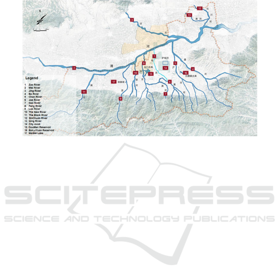
Figure 1: The location of “Eight Rivers around Chang'an” and Zao River.
Urban context is the sum of all material and
spiritual wealth created by people living together in
the same area. Different natural conditions and
living conditions lead to different cultural
temperament. Only by protecting urban context will
inherit and continue the historical memory by each
generation (Gao, 2016). The material form of urban
culture context is reflected in the natural
environment that natural geography and
hydrogeology are important components of urban
context. Human gave urban natural environment
humanistic connotation by using and transforming
the natural environment. For example, the historical
river and lake water system around Chang'an is an
important element of Xi'an urban culture context. As
shown in Figure 1, the location of Eight Rivers
around Chang'an and Zao River is shown.
Historical water system is a natural river and lake
system or artificial canal system which has great
historical significance to the formation and
development of a city, plays a decisive role in the
city location and relates to the historical changes of
the city (Guo, 2010) (Wu & Liu, 2017). Historical
water system is the result of human long-term
practice of urban water conservancy, which directly
affects the location, shape and pattern of the city. It
has rich historical and cultural landscape view,
contains a large amount of historical and cultural
information, witnessing the process of urban
development and decline, and is the carrier of urban
history and culture (Han, 2019), and also affects the
spatial layout, flood safety, open space, residents'
activities ecological security and other aspects. It is
an important way to inherit the city culture to protect
the culture of historical water system and explore the
characteristics of waterfront landscape. Water
management is a traditional method in ancient China
and people have a deep understanding of water in the
construction of environment. Only by correctly
interpreting the water culture can we inherit and
continue it. Water and city are constantly changing
and creating historical culture together (Duan, 2013).
Water culture has its own characteristics, so it is
necessary to protect and create unique water culture
to keep the cultural context of the city inherit.
Some waterfront landscapes in China lack of
systematic planning. Existing planning lacks of the
overall concept and design theme, just stacking the
elements of each landscape, lack of landscape
continuity. Some ignore the local climate,
environment, history and local characteristics in the
design process, resulting in the cultural deficiency
(Diao, 2020). The current situation of river
landscape development in China can be summarized
as follows (Yang, 2014): the awareness of
"ecological construction" is enhanced, but there are
still some practices which violate ecological
principles, such as "cutting the bend and
straightening", "cement lining"; The design of
waterfront green space and open space does not fully
consider the user's needs, and the utilization rate is
not high; Lack of consciousness of protection of
historical landscape, insufficient excavation of
historical culture and regional characteristics, and
The Waterfront Space Planning of Urban Historical River based on Cultural Context: Taking Xi’an Zao River Park as Example
89

serious assimilation of design; The waterfront
features were not highlighted. The successful river
landscape can be used by designers to utilize the
original historical and cultural resources along the
river, retain the special nature of existing places, and
have enough respect for the local cultural
connotation, so as to make the waterfront landscape
show strong regional characteristics and historical
and cultural atmosphere (Yang, 2014). There are
cases in foreign countries that classify historical
waterfront areas into the heritage corridor system for
overall protection. For example, some canal
heritages include waterfront areas in the protection
and display of heritage corridors, such as the MIDI
canal in France, the central canal in Belgium and the
Lido canal in Canada.
Urban waterfront landscape is the recorder of
urban changes, which has important cultural value,
and could reflect the characteristics of local water
system, displaying urban history and culture,
establishing the sense of belonging of urban residents,
meeting their spiritual needs and stimulate creativity.
Figure 2: The location of Zao River and its tributaries.
3 THE CULTURE CONTEXT OF
ZAO RIVER
3.1 The History of Zao River
Zao River is one of the important rivers in Xi'an, and
is also the primary tributary of Wei River. It
originates the northern slope of Qinling Mountains
in Shuizhai Village of Chang 'an district in Xi'an,
flows through Shendian and Weiqu of Chang 'an
district, enters the urban area of Xi'an at Xiatapo,
and enters Wei River from Ducheng, Zhangbagou,
Yuhuazhai, Beishiqiao, Sanqiao Town, Yanquemen,
Liucunbao to Caotan Farm, with a total length of
about 30km. The length in urban area of Xi'an is
about 27km and the basin area is about 300km
2
(Dong et al., 2012). Zao River passes through
Zhangbagou and Yuhua area in Xi'an, leaving
different characteristic and historical legends. The
river location is shown in Figure 2.
Zao River has a long history with natural and
human geography characteristics and is one of the
historical symbols in Xi'an. Zao River was the
ancient channel of Jue River, which was excavated
as a canal for transporting wood for government. Jue
River is divided into two branches near Niutou
Temple. The north is Zao River and joins with Hao
River in the west.
The earliest record of “Zao River” in the
literature was during the Qianlong period, “Cao
River” flowed to the vicinity of Yong Gate of the
Han Chang’an City site and turned northwest, which
was locally called “Zao River Bend”. It was
recorded in “Continued records of Xianning and
Chang’an Counties”: “Zao River is the downstream
section of Jue River, and it enters from Huangzipo of
Xianning County and flows 7.5km northwestward
into the moat. 15km away is the site of Han
Chang’an City, which is called Zao River bend and
flows 30Li northeastward into Wei River.”
The “Xijing Planning” (1941) written by the
Xijing Preparatory Committee stated: “The eighth is
Zao River, also known as Algae River. Its upstream
is Jue River, flow northwest to Zhangba Gou water
gate, divided into two: one flow northeast into city
known as Xilong canal, or named Tongji canal;
another one discharges water from the gate to south
turning from the west to the north, which is the main
form of Zao River, and enters Wei River through the
ancient city of Han Dynasty. The downstream often
silt because of the irrigation in the upstream.”
3.2 Development of River System
Context
As an important part of urban water systems, the
historical water system has been gradually
transformed into ditches, landfilled into dark
channels or disappeared due to urban construction in
the urban development process. The water surface
rate in the urban built-up area has gradually
WRE 2021 - The International Conference on Water Resource and Environment
90
decreased, water pollution is serious, the ecological
function of rivers is lost, and the water network
structure is broken (Wang, 2020), which affects the
connectivity of water system and the display of
historical culture of water system.
Xi'an is a national historical and cultural city, and
the historical water system is closely related to Xi'an
urban development and pattern, which is an
important part of Xi'an culture context. Although it
has such rich cultural heritage, some historical water
systems are gradually losing their cultural value due
to the lack of planning integration and display, so the
context of urban water systems is difficult to
continue. Zao River is also one of the representatives
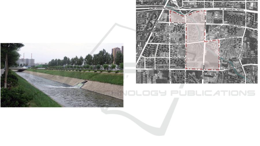
of such historical water systems, as shown in Figure
3. Due to the lack of planning integration and display,
the ecological function of Zao River is basically lost,
the excavation of water culture is not enough, and
the lack of ecological landscape construction, the
current construction of water culture cannot meet the
needs of urban quality improvement and residents'
living entertainment.
Figure 3: Status of Zao River.
With the increasing attention from the protection
and inheritance of urban historical culture context,
the historical heritage protection objects have
gradually evolved into the sustainable protection of
the overall historical environment in recent years. At
the same time, the protection of water cultural
heritage has received more attention from society,
such as the Grand Canal heritage corridor protection
(Xi, 2012), the construction of Beijing water system
heritage corridor (Wang, 2012) and so on. As part of
urban water cultural heritage, historical water
systems should be given corresponding protection.
At present, the urban master planning and
various special planning are combined with urban
green spaces, integrating the land use, giving space
to waterfront areas, planning landscape for the
historical water system and the space along it, so as
to carry the historical culture and local
characteristics. The master plan of Xi'an proposes to
coordinate the urban water system with the river
basin and regional water system under the full
consideration of the requirements of urban flood
control and drainage and tourism landscape, taking
into account the requirements of water safety, water
resources, water environment and water culture.
In view of the current situation of Zao River site,
the ecological method is used to supplement water,
so as to realize the water cycle of urban landscape
and improve the water quality of urban landscape,
and to create the original ecological leisure
sightseeing wetland park, to make it an urban
waterfront open space that shows and maintains the
natural ecology, and inherits the historical water
system context, and respects humanity. The park site
is shown in Figure 4.
Figure 4: Planning range of the ecological park of Zao
River.
4 PLANNING CONCEPT AND
EARLY CONTROL
4.1 Regional Background and Planning
Concept
As an important part of urban spatial system, the
urban historical water system has a significant
impact on the overall layout, form, site selection and
characteristic style of the city (Han, 2019). Due to
the rapid development and spread of the city, the
river water system space was occupied by urban
space, and the urban historical water system is
seriously damaged, and the hard treatment of the
coastline is based on the impermeable paving
method around, which also seriously destroys the
ecology of the water system. The urban master plan
has adjusted the land use in this area to optimize the
function of the park and its relationship with the
surrounding lands, as shown in Table 1 below.
The Waterfront Space Planning of Urban Historical River based on Cultural Context: Taking Xi’an Zao River Park as Example
91

Table 1: Comparison of district planning.
Land Usage
District
Planning
After Adjustment The Variation Quantity
Area(ha) Area(ha) Area(ha)
Residential
(
R2
)
0 33.99 33.99
Cultural Facility(A2) 0 1.00 1.00
S
p
ort
(
A4
)
0 5.00 5.00
Commercial Facility(B1) 10.79 41.10 30.31
Green Land for Park
(
G1
)
103.05 24.28 -78.77
Green Land for Environmental
Protection
(
G2
)
55.23 63.70 8.47
Transport Facility(S)
25.56 25.56 0
Total 194.63 194.63 0
The study carried out preliminary positioning and
element control started from two important elements
which are context and ecology.
From the perspective of culture context, the
design respects the inheritance of history and culture.
The design also needs to fully analyze the cultural
and historical conditions of the city, integrating
design with history and culture, and retain site
memory. Unique historical changes and cultural
development are rich in historical heritage and
cultural connotation, which are the key to construct a
cultural corridor with urban characteristics and are
important background for construction. To continue
the context, the attention should be paid to urban
characteristics and avoid homogeneous waterfront
space and landscape design. The significance of
regional culture is reflected in urban characteristics,
so the design should reflect and display the context
from multiple levels and angles such as space to
form and express the culture context with waterfront
space characteristics.
From the perspective of ecology, following the
important principles of ecological civilization is the
premise of ecological security and water security.
The waterfront area is a specific area of the city, an
area with a certain width connected between land
and water in the city. The water system and its
surrounding areas are taken as the research object to
ensure ecological continuity and ecological security.
At the same time, the water system has important
functions of urban disaster prevention and reduction,
which has great significance to urban safety pattern.
Waterfront is a green opening space close to the
water area. The planning and design aiming at
ecology, recreation and aesthetics to realize urban
waterfront spaces renew and reform. It is conducive
to the sustainable development. For the water system
with historical value, while continuing the historical
information, the design should also be given new
functional value, so as to provide high-quality
conditions for urban environment and residents' life.
For example, most of the greenways in New York
were built on the Hudson River, and each tour route
relies on natural and cultural landscape resources to
create characteristics and show urban vitality (Yu,
2012). In the planning and design, designers should
pay attention to history and the present at the same
time and pay attention to the interaction between the
historical water system and residents, rather than
forming two isolated systems, so as to maintain the
hydrophilic vitality of the urban water system.
4.2 Preliminary Control of Planning
and Design
The early control of planning and design is mainly
carried out from the perspective of things and people.
The subject of things is the historical water system
and waterfront environment, and people aspect is
mainly to control people's feelings and behavior.
The waterfront design of historical water system
needs to respect the historical attributes of water
system, including its location, function, shape, style,
etc. The basic principle of planning is not to change
the location and trend of the original river channel,
then try to make use of it locally. The design should
fully analyze the topography of the waterfront area,
skillfully use the elevation difference in combination
with the geological conditions, to carry out the plane
and vertical planning and design, so as to form a
good relationship between the road arrangement and
the contour line, which is convenient for driving and
WRE 2021 - The International Conference on Water Resource and Environment
92

walking. At the same time, the design should fully
analyze the waterfront section, on one hand to form
a connected and effective transportation system, on
the other hand to comply with the growth law of
waterfront vegetation and reasonably layout
ecological plants.
The waterfront environment of different
historical water systems is different. Such as the
water system with irrigation channels as the main
body. The elevation difference of terrain around the
channel is generally not as large as that of natural
water system. Topography is one of the visual
manifestations of identifying artificial channels and
natural rivers. Therefore, the elevation difference of
waterfront topography should also be respected, and
its historical real environment should be maintained.
Observing the river width and depth of the water
system can also distinguish whether it is a
transmission and drainage channel or a natural river.
Taking Zao River as an example, as an irrigation
channel, its width is relatively narrow and there is no
washed floodplain around. In the design, the
attributes of river water system should be respected
as much as possible. While ensuring the hydrophilic
concept, it should not be designed to broaden the
river channel and increase the types of waterfronts.
For the waterfront planning and design of urban
water system, it is also needed to pay attention to the
subject of human. Public facilities often ignore public
participation, lack of humanistic care and ignore
people's needs (Diao, 2020). In the design, we should
pay attention to the guidance of human behavior, pay
attention to the setting of stay point, affect human
behavior through the design of path and node, and
stimulate the vitality of the site by activating human
behavior. Therefore, it is necessary to accurately
locate the path in the planning and design. Firstly, the
site landscape resources shall be defined from the
human starting point, including natural landscape,
artificial landscape, cultural landscape, etc., including
the landscape resources forming waterfront
characteristics, such as landform, water body,
shoreline, historical and cultural scenic spots, ground
markers, interactive landscape, plants, historical sites,
etc. The design should fully exploit and utilize these
contents. Secondly, the design should define the
influencing factors in the design, extract the main
influencing factors, that is, the main body of the
display, like main water body related design, and then
determine other factors, such as water surface
environment, historical and cultural nodes, etc.
Through the dual control of things and people,
the scheme shows the cultural characteristics of
cities and historical water systems, to realize the
interaction between people and historical culture. In
the waterfront design of Zao River, put human
elements in a large mountain and river environment
view, to reserve sight corridor from Qinling
Mountains to Zaohe River; Put human elements in a
small view, by displaying Zao River itself, to show
the grand scenery of “eight rivers around Chang'an”
river system.
5 SCHEME DESIGN OF ZAO
RIVER WATERFRONT PARK
5.1 Waterfront Shoreline Design
In order to meet different functional and spatial
needs, different revetment types are created through
the design by different slopes and plant communities.
The design uses the near-natural treatment method to
create natural ecological revetment, rationally utilize
the ecological environment of floodplains, and shape
the ecological natural environment, to stimulate
waterfront vitality. In the scheme generate process,
ecology arrangement, flood control, landscape and
other aspects, should be considered to achieve the
residents wishes that living in the city but yearning
and feeling the nature, providing waterfront
environment comfortable natural environment.
The waterfront environment includes water
ecology and green space ecology. Zao River is a
channel in the planning area. In the landscape
transformation and upgrading design period,
combined with the specific functional zoning of park
planning to reform the shoreline, to create natural
ecological revetments for stimulating waterfront
vitality. The natural stone beach, grass slope
revetment, aquatic plants revetment and other forms
could be used.
In addition, the southwest part of the planning site
has elevation difference. The scheme uses platform
garden to connect shoreline and the river, combined
with the concept of Low Impact Development to
design rainwater garden for stormwater management,
so that precipitation and some river runoff can be
well used in this area. In the plant disposition, the
scheme chooses both decontamination and
ornamental plants and flowers, such as Albizia juncea,
Metasequoia glyptostroboides, Photinia rubra,
Pennisetum chinense, Ceratophyllum demersum, Iris
aquaticum, etc.
For the nearshore area management, the flood
zone is set for dechannelized river part, which is
guaranteed by the upstream and downstream water
quantity control, making the flood range controllable.
The Waterfront Space Planning of Urban Historical River based on Cultural Context: Taking Xi’an Zao River Park as Example
93
The area adopts the waterlogging resistance design
to enhance the permeability, adopts the
flooding-tolerant stones, herbs and shrubs, without
arbor trees. The river bank landscape is shaped to
enhance the hydrophilicity. In order to cope with the
influence of water level change on shoreline
landscape and facilities, the plan designed the trestle
of anticorrosive wood and stone laying in this area.
Combining natural landscape with river flood
control, the original rigid flood control facilities are
partly reformed by using natural treatment methods.
New riparian protection measures, such as widening
river beds, are adopted to improve flood control
capacity and provide safety assurance for activities.
Wide riverbanks create a hydrophilic space for
people to relax and entertain, so that the distance
between people and rivers closed, and the natural
interaction increased.
5.2 Waterfront Transport Planning
The setting of transportation system is divided into
static transportation and dynamic transportation.
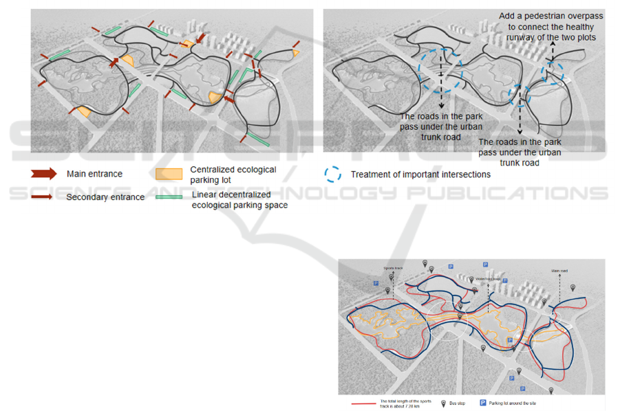
The static traffic system (Figure 5) includes
entrances and exits planning and parking lots
planning to solve the bus travel problems, and also
transfer and parking problems. The entrance and exit
are combined with the location of the pedestrian
crosswalk of the urban road around the site and the
location of the public transport station, which is
convenient for residents to identify and reach. More
than ten primary and secondary entrances are
designed to improve the accessibility to the park.
Figure 5: Schematic diagram of static traffic system.
Zao River Ecological Park planning and design
has two ways to meet the residents' demand for
parking: centralized ecological parking and linear
decentralized ecological parking. Taking into
account the nature of the ecological park, all parking
lots put on the ground. The centralized parking space
is set near the main entrance of the park, which is
convenient for residents to park as soon as possible
after entering the park, reducing the driving distance
in the park and the interference of walking residents
and sightseeing vehicles in the park. The linear
decentralized ecological parking space is mainly set
at each open secondary entrance, combined with the
internal tourist routes of the site, integrated into the
ecological landscape to minimize the impact to the
park.
A three-level road network system is set up in the
dynamic traffic system (Figure 6).
Figure 6: Schematic diagram of dynamic traffic system.
Firstly, the primary road network is a lane
connecting urban roads inside and outside the site,
which is used to meet the driving functions of the
site, such as the connection of the main areas in the
garden and the driving of sightseeing vehicles.
Secondly, the secondary road network breaks
through the block limit, adopts special connection
WRE 2021 - The International Conference on Water Resource and Environment
94

mode, and combines several block areas of land to
form a continuous trail to avoid crossing urban roads.
The continuous trail is a jogging system in the park,
which is used as the runway and bicycle trail for
sports. It realizes the penetration and continuity of
the internal road system (Deng, 2020), which has the
total mileage about 7.28km.
Finally, the third level is walking waterfront
landscape loop and garden path. The road network
at this level bears the responsibility of connecting
cultural nodes and ecological units to ensure the
accessibility of the park. In terms of cultural function,
it is used as the carrier of Zao River culture path
design, showing different culture content, historical
and cultural elements, so that residents can walk and
learn while appreciating.
In addition, for the management of important
intersections, according to the current situation of
the site and the terrain elevation difference, the
elevation difference space is formed below the plot
passed by the Xifeng 1st Road and the Xifeng 3rd
Road. The roads in the site pass under the urban
roads, which ensure the continuity of the roads inner
the park. The Shenjiaqiao 2nd Road separated two
plots in the northern part of the site, connected the
slow walkways of the two plots by adding pedestrian
overpasses, which played a role in connecting the
plots and ensured the safety of residents walking.
The design refers to Minneapolis Park in the
United States and introduces a multi-level composite
transportation system (Yang et al., 2020). Firstly, the
continuous shade road runs through the whole park
system to form 88.5km shade roads. Secondly, the
continuous vehicle lane and walking road are created.
Three types of roads in design form the traffic system
according to the slow speed of 5, 15 and 40km/h, and
are effectively connected urban transportation.
5.3 Waterfront Ecological Design
The river system is an important part of urban
ecological environment. In the process of shaping
waterfront landscape, we should pay attention to
follow the principles of integrity and rationality of
river system ecosystem and the diversity and
dominant dominance of river function (Zhang, 2020),
to create waterfront space symbiotic with urban
natural ecology.
The water conservancy and hydrological process
of river and its waterfront is the decisive factor of
river ecosystem and other surrounding ecosystems
(Zhang, 2020). Zao River used to be an ancient road
of Jue River. Jue River is divided into two branches
near Niutou Temple. The current Zao River is to the
north, and its tributaries include Dahuan River, Feng
2nd Canal and Taiping River. As one of the five
major drainage systems (Ba River, Chan River, Zao
River, Caoyun Open Channel and Happiness
Channel) in Xi'an City, Zao River has long been
mainly receiving urban rainwater from the southern,
western and northern suburbs of city, as well as
reclaimed water from nine sewage treatment plants
along the line, with a daily discharge of about 1.3
million tons. In order to further improve the water
quality of Zao River and the landscape features
along it, corresponding ecological treatment is
needed.
The construction of water system space in
waterfront should avoid the destruction and
interference of artificial construction (Zhang, 2020).
Waterfront greening should adopt natural design,
paying attention to the organic connection between
river water system and surrounding ecosystem, and
select the appropriate location to create ecological
space based on artificial channels. Based on the
concept of landscape ecology, the ecological
landscape structure of “patch-corridor-matrix” is
constructed. Firstly, on the basis of the current land
use of Zao River, local plants are used to carry out
ecological bottoming to form an ecological matrix.
Then the landscape along the waterfront is shaped to
form a water ecological corridor. Finally, multiple
ecological landscape nodes are designed to complete
the decoration of ecological patches, so as to erect
the landscape structure.
The planning firstly naturalizes the river bank,
selects the corresponding river section to broaden the
water surface. Some are used for shaping the
waterfront landscape, and some are used for
ecological maintenance and improvement. The
influence of ecological factors is considered in plant
planting collocation, landscape sketch and facility
material selection, and the concept of low impact
development is followed by setting rainwater
gardens, ecological parking lots and
waterlogging-resistant structures in combination
with terrain.
For the ecologically sensitive areas of Zao River,
ecological islands are added locally for maintenance
and restoration (Liu et al., 2016). On the one hand,
the self-purification capacity of ecological islands
can prevent eutrophication and improve water
quality of Zao River. On the other hand, the park
water system with good ecological environment will
attract bird activities and stops, enriching the animal
ecological environment in the park. In addition,
island landscape is also an important part of
waterfront space.
The Waterfront Space Planning of Urban Historical River based on Cultural Context: Taking Xi’an Zao River Park as Example
95

5.4 Cultural Routes Planning
Zao River has a long history. It was originally the
Jue River ancient road, and in ancient times it was a
river channel excavated as a palace canal for
transporting wood. However, due to the lack of
construction investment and maintenance for a long
time, the ecological function of Zao River has been
basically lost, excavation of water culture is
insufficient, and the construction of ecological
landscape is missing, so that the current construction
of water culture cannot meet the needs of quality
improvement and residents’ living and entertainment
in cities along the river line.
Human landscape is the symbol of the city, and
rivers are the carrier of cultural expression. Based on
the excavation of Zao River and its related urban
context, the ideological culture is expressed by
means of material entities, and the entities are
displayed in planning and design in the form of
buildings and landscapes, so that people are easy to
contact and perceive (Cao, 2018).
In the space landscape design of the site
containing cultural context, the original natural
resources should be protected and utilized as much
as possible, and the original space texture should be
maintained so as not to be destroyed in a wide range
(Cao, 2018). Therefore, in the landscape design of
Zao River District, we should firstly respect its
history and culture. The program highlights the
cultural characteristics of the area through the
display of natural characteristics such as canals and
raw timber use. The specific principles are as
follows.
Rely on natural linear conditions. Inland river is
a natural resource for the city, and its limited
waterfront space is important landscape and public
place of the city. The development track of the city
in time is depicted in the spatial sequence of the
waterfront area and becomes an important' cultural
line' for reading the city (Wang et al., 2010).
Implant regional cultural themes. The scheme
organizes the cultural space of whole region in
culture routes way, strengthened the cognition by
using space nodes. By establishing humanistic space
nodes, while forming a clear infrastructure, we can
build the order and integrity of space in cultural
representation. In the construction process of the
cultural nature of the urban leading space, taking
local culture as the background, extracting regional
cultural themes and implanting them into the
construction process of line space, which is an
important method for unifying and connecting
various humanistic nodes.
The road plays a role of connecting nodes,
connecting sites and spaces, guiding people to
experience and perceive the site, and it is also the
carrier of site culture display, has a natural linear
guiding role. The planning scheme combines the
historical context of Zao River to create a number of
thematic cultural routes. Through buildings, sketch
facilities, sculptures, inscriptions, pavements and
other forms, the design popularizes science to park
residents and displays urban history and culture
related to Zao River Area.
The planning scheme designs four main cultural
theme tour routes according to the theme, which are
the cultural routes with the theme of Xingsheng
culture, Chang' an river system culture, Zao River
classical culture and Cannel culture.
The topographical advantages cultural theme
route: Xi'an faces Qinling Mountains in the south
and eight rivers in the north, forming a special form
of scenic spots. This cultural route mainly shows the
landscape pattern of Xi'an, through small volume of
landscape sketches represent the landscape of Xi'an,
so that residents can intuitively feel the landscape
pattern of Xi'an city.
The eight river culture theme route: "the eight
rivers are scattered, different from each other". From
eight river flowed around Chang'an city in the Han
and Tang dynasties to Xi'an city today, there are
eight rivers, namely, Wei River, Jing River, Feng
River, Lao River, Jue River, Hao River, Chan River
and Ba River, flowing through Xi'an city and are
indispensable part in the urban history of Xi'an. This
cultural route mainly carries out the popularization
of basic information of eight rivers, historical
changes of rivers, and the popularization and display
of water conservancy planning and engineering
achievements of “Eight Rivers around Xi'an” in the
new era. The scheme designed the eight rivers
sculpture model, through the interaction of water
injection let residents experience the fun to make
eight rivers alive.
The canal culture theme route: the canal flowed
over 300 miles in Xi’an, from Kunming Lake to the
north, and then passed through Chanba to form a
large water transport platform, Guangyuntan, and
then from the canal to the east to form water wharf,
which is an important part of human canal
civilization. The cultural route mainly displays the
history and culture of the artificial channels, and
displays the contents of the historical documents in
stone carving, so that the residents can understand
the relevant channel culture deeply.
The Zao River allusions theme route: Zao River
flows through the site, which is the most important
WRE 2021 - The International Conference on Water Resource and Environment
96

context in the site. This theme path mainly shows the
historical changes of Zao River, the poems and
songs related to Zao River, and the current special
governance plan. By engraving poems on facilities
such as lampposts, ground lamps and water
guardrails, the cultural atmosphere of the site is
enhanced and the cultural impression of Zao River is
strengthened.
6 CONCLUSION
The river system is the foundation of the
establishment and development of a city, witnessing
the prosperous and decline of a city. The historical
water system that has been used so far is also a
symbol of urban civilization. The history and culture
of urban river systems determines that the design
should respect history, retain place memory and
people's basic cognition, to stimulate the affinity of
history and the vitality of waterfront, and to make the
waterfront area a symbol of urban history. Relevant
planning involves the design of urban planning land
layout, hydrology and water conservancy
demonstration and design, landscape design, heritage
protection and so on, should be studied and
implemented based on comprehensive demonstration.
To meet the contemporary functions of the river and
ensure its water transmission and flood control
capacity, it is also necessary to carry out elastic and
ecological design of the water system, combining the
layout of planned land with urban green space, to
create an open space with reasonable scale and
provide a site for residents' activities. The layout of
the site needs to strengthen the display design of
shoreline, road and context, so as to continue the
water system context of the historical city.
ACKNOWLEDGMENTS
This study has been supported by Shaanxi Provincial
Department of Education Key Scientific Research
Project (Grant number 20JT054), Project of National
Natural Foundation of China (Grant number
71774132), Shaanxi Water Conservancy Science and
Technology Project (Grant number 2020SLKJ-22).
REFERENCES
Cao, X. J. (2018). Urban design based on urban context.
City, 4, 28-33. (in Chinese)
Deng, Y. Q. (2020). Research on landscape design of
waterfront greenway non-motorized transport system –
Taking Zhaoyuan Kingquan waterfront greenway as an
example. Beijing Forestry University.
Diao, S. X. (2020). Research on urban waterfront
landscape design based on symbiosis - a case study of
the waterfront landscape of Wuzhong Taihu new town,
Suzhou. Soochow University.
Dong, W., Li, H. E., Li, J. K., Qin, Y. M., & Zhu, L. (2012).
Analysis on water quality of severely polluted urban
river, Zaohe River as an example. Journal of
Hydroelectric Engineering, 31(04), 72-77.
Duan, J. T. (2013). Examine the use of landscape design
elements in the Ruins Park in the context continuation
perspective. Xi’an University of Architecture and
Technology.
Gao, Y. C. (2016). Public Art Design research Under The
View of Urban Context Protection. Tianjin University.
Guo, Y. Z. (2010). Study on the protection of urban
historical water system. Beijing University of
Technology.
Han, C. (2019). Multi-value promotion based research on
regeneration strategy of urban historical water system
– take Changchun for example. Jilin Jianzhu
University.
Liu, J. L., Liu, J. K., Anderson, J. T., Zhang, R. & Zhang.
Z. M. (2016). Potential of aquatic macrophytes and
artificial floating island for removing contaminants.
Plant Biosystems - An International Journal Dealing
with all Aspects of Plant Biology, 150(4), 702-709.
Miao, Y. (2005). Research on assessment and inheritance
method of Chinese traditional urban contextual
constitutions. Urban Planning Forum, 4, 40-44, 27.
Shi, M. J. (2013). Research on the planning and design of
waterfront city Ribbon Park North. Northeast Forestry
University.
Wang, H. Y. (2020). Study on value evaluation and
rehabilitation planning of urban historic water system.
Beijing University of Civil Engineering and
Architecture.
Wang, J., Zhang, L. L. & Dai, X. X. (2010). “Cultural
router” in urban space. Huazhong Architecture, 28(07),
148-150.
Wang, L. (2012). Research on the construction of river
heritage corridor in Beijing. Beijing Forestry
University.
Wu, J., & Liu, W. F. (2017). Beijing historical river
system improvement based on ecosystem services.
Ecological Economy, 33(10), 199-204.
Xi, X. S. (2012). Construction of Grand Canal Heritage
Corridor. Beijing: Publishing House of Electronics
Industry.
Yang, S. (2014). The inheritage and revival of city’s
historical context – Taking historical and cultural
landscape plan of the Yellow River in Xuzhou as
example. China University of Mining and Technology.
Yang, W. Y., Yang, R. Y., & Fan, Y. L. (2020). Illumination
of urban parks planning in Minneapolis. Planners,
36(17), 83-89.
The Waterfront Space Planning of Urban Historical River based on Cultural Context: Taking Xi’an Zao River Park as Example
97

Yu, W. (2012). The analysis on East coast greenway
construction in America, The case of New York
Greenway. Architectural Journal, S2, 5-8.
Zhang, L. (2020). Research on waterfront landscape
design based on river ecological restoration concept –
Taking Xiang River landscape planning in Yu County
as an example. Beijing Forestry University.
WRE 2021 - The International Conference on Water Resource and Environment
98
