
Online Inference of Robot Navigation Parameters from a Semantic Map
Benjamin Kisliuk
1
, Christoph Tieben
1
, Nils Niemann
1
Christopher Br
¨
ocker
1
, Kai Lingemann
1
and Joachim Hertzberg
1,2
1
German Research Center for Artificial Intelligence, Plan-based Robot Control Group, Osnabr
¨
uck, Germany
2
Universit
¨
at Osnabr
¨
uck, Knowledge Based Systems Group, Osnabr
¨
uck, Germany
Keywords:
Semantic Map, Navigation, Robot Autonomy, Semantic Navigation.
Abstract:
Agriculture is becoming one of the key application fields for mobile robots. At the same time it poses se-
rious challenges for true autonomous systems due to its heterogeneous and dynamic nature. To act robustly
and reliably, robotic behaviour needs to be controlled by an intelligence, making explainable and informed
decisions based on knowledge of its surroundings. However, this knowledge cannot only be derived from sen-
sor data but has to be based on prior knowledge and external sources as well to comprehensively represent a
robots deployment site. By representing this knowledge in formal and thus machine readable way, automated
inference improves the handling of the complex nature of these requirements. In this paper, we show how
quantitative and qualitative control parameters regarding a mobile robots navigation can be derived from a
manually modelled semantic map of an agricultural deployment site. Also we describe how such a system
can be integrated into a typical ROS system architecture. By making the derived knowledge easily available,
the robotic system is enabled to dynamically adapt route planning on an agricultural deployment site and to
switch between different local planning algorithms according to situational and prior knowledge.
1 INTRODUCTION
In agriculture, robots are widely considered an impor-
tant building block to the future of a more sustainable
source of food and primary production with various
projects demonstrating success, mostly in singular ap-
plications (Bergerman et al., 2016).
Automation can help streamlining processes, and
autonomous machines can enable processes which are
too complex to be managed efficiently by humans.
Current research projects often focus on multi-robot
systems, which act and decide partially or completely
without human supervision (Shamshiri et al., 2018).
As of today, most commercially available robots
are able to execute certain agricultural processes, but
still lack the capability of an integrated approach
(Bergerman et al., 2016; Shamshiri et al., 2018). This
can be partially attributed to the complexity of the do-
main and the multitude of conditions and processes
required to run an agricultural business; but also the
agricultural sites, i.e. farms, are usually very hetero-
geneous spaces, which are – from a roboticist’s point
of view – far from well structured in a robotics sense
and dynamic by nature (Kunze et al., 2018; Egerstedt
et al., 2018). Thus, a robot which is supposed to run
autonomously will be challenged to deal flexibly with
a lot of problems and steep constraints regarding reli-
ability and robustness while behaving and deciding in
a comprehensible and explainable way (Langley et al.,
2017).
In practice, integrating robotic software often
means that it is up to the roboticist to decide which
approach or existing implementation of a certain tech-
nology – like navigation or task-planning and their re-
spective parameters – fit the overall constraints best.
A flexible approach allowing the robot itself to au-
tomatically choose between different approaches ac-
cording to which fits best in a specific situation can
improve the ability of a robot to interact with a com-
plex environment enormously like the Move Base
Flex framework for navigation (Putz et al., 2018).
From that flexibility however, the question arises how
to choose the best algorithm or control parameters for
a given situation or context.
This paper demonstrates the usage of a reasoning
engine over a semantic map of the geospatial envi-
ronment as a key component to tackle challenges of
autonomous robot control. We will show how seman-
tic knowledge about the area the robot is deployed in
– the deployment area – is modelled by annotating
156
Kisliuk, B., Tieben, C., Niemann, N., Bröcker, C., Lingemann, K. and Hertzberg, J.
Online Inference of Robot Navigation Parameters from a Semantic Map.
DOI: 10.5220/0010790200003116
In Proceedings of the 14th International Conference on Agents and Artificial Intelligence (ICAART 2022) - Volume 1, pages 156-163
ISBN: 978-989-758-547-0; ISSN: 2184-433X
Copyright
c
2022 by SCITEPRESS – Science and Technology Publications, Lda. All rights reserved

a geospatial map with semantic knowledge. The re-
sulting semantic map in combination with informa-
tion sources like weather data, the current time of day
and the robots position can be used to infer control pa-
rameters online. For representation we use a custom
software called SEMPR with an integrated rule based
reasoner using the RETE pattern-matching algorithm
(Forgy, 1982).
We will show as an example how 2D navigation
cost maps can be generated from the inferences and
used for path planning in a robotic system.
After this introduction to the problem the second
chapter will provide information about the theoretical
background and state of the art. In the third chap-
ter we describe the implementation of the necessary
components and show how they integrate into a ROS
robot architecture in chapter four. Lastly, we summa-
rize the system and show prospective future avenues.
2 BACKGROUND
In modern times mobile robot control architectures
commonly base a robots behaviour on the input of
the sensors and the results of some deliberation pro-
cess. However, not every relevant information can or
will be sensed by the robot: In the agriculture domain
properties like ground moisture, dust or the quality
of daylight often will not be sensed due to the lack
of specific sensors or appropriate software modules.
Some types of information cannot be derived from
on-board sensory data at all, e.g. the legal situation
regarding ownership of a plot or a weather forecast.
This motivates the use of an environment representa-
tion which covers information about the deployment
site which can be enriched with prior knowledge. To
further enhance the autonomy of the robot control
software, this knowledge should be expressed in a for-
mal way which allows it to be interpreted by a reason-
ing software.
In (Hoellmann et al., 2020) a simple approach to
handle different contexts which cannot or will not
be sensed by the robot is described: By dividing an
overall heterogeneous deployment site into subareas
with in themselves higher homogeneity like single
fields, yard areas, buildings or pasture areas, zones
with more specific constraints were defined. Based on
the context defined by a zone, control parameters and
navigation algorithms were chosen according to pre-
defined parameters. However, the limitations of this
approach became clear quite early. While the context
based approach was able to tackle the heterogeneity
of the deployment site, it is not flexible enough to re-
gard dynamic changes or complex interconnections.
A more comprehensive approach can be taken by pre-
defining only singular facts, making them changeable
at runtime and using a rule based reasoning system
to infer the control parameters for the robot at run
time. This can be understood as three main compo-
nents: The semantic map which incorporates geospa-
tial anchored knowledge, a set of formalised rules and
a reasoning algorithm.
From intuition, this approach offers multiple ad-
vantages: Independent knowledge can be modelled
independently. This allows for discussing relevant in-
formation about a deployment area with experts in the
domain using non-technical terms in the interviews.
Also the complexity of the system architecture can be
reduced drastically, as new facts can easily extend the
knowledge base as do new rules or relations. Lastly,
every decision that such a system makes can be easily
explained to a human user by extracting the chain of
rules and facts which led to an inference.
2.1 Semantic Maps
Enriching spatial maps for robots goes back at least
to the works of Kuipers, Buschka in the early 00s
(Kuipers, 2000; Buschka, 2005). Galindo et al sug-
gest a hierarchy of map representations (spatial, se-
mantic) and ”anchor” semantic meaning to objects
and places (Galindo et al., 2005). N
¨
uchter and
Hertzberg showed how semantic annotation can be
automatically applied to 3D SLAM Maps by reason-
ing over previous knowledge in form of a constraint
network to enhance scene interpretation and automate
annotation (N
¨
uchter and Hertzberg, 2008). Pronobis
reflects on place classification and the generation of
semantic maps and the enhancement of object search.
The mapping process is defined broadly as associat-
ing spatial concepts (e.g. ”kitchen”) with spatial enti-
ties (e.g. a polygon on map) (Pronobis, 2011). Lang
and Paulus formally define a semantic map as a hy-
brid map of spatial and semantic information with the
stress of the semantic information being represented
in a way which allows for inference (Lang and Paulus,
2014). At the same time Kunze et al use reasoning to
enhance object recognition (Kunze et al., 2014). In
a survey Kostavelis and Gasteratos claim that most
works regarding semantic mapping describe robotic
indoor scenarios, note however that the use of seman-
tic maps for robotic applications increases (Kostavelis
and Gasteratos, 2015). Deeken et al generate low
level occupancy grids from a semantic map (Deeken
et al., 2015) while other works apply semantic maps
to navigation in form of land mark recognition (Cos-
gun and Christensen, 2018). In recent years, Kunze et
al anticipate a strong yet growing trend for semantic
Online Inference of Robot Navigation Parameters from a Semantic Map
157
Rule-Based Inference System /
Reasoner
Domain-Specific Rules
(Extended)
SPARQL-Interface
Entity
Component Component ...
Persistence
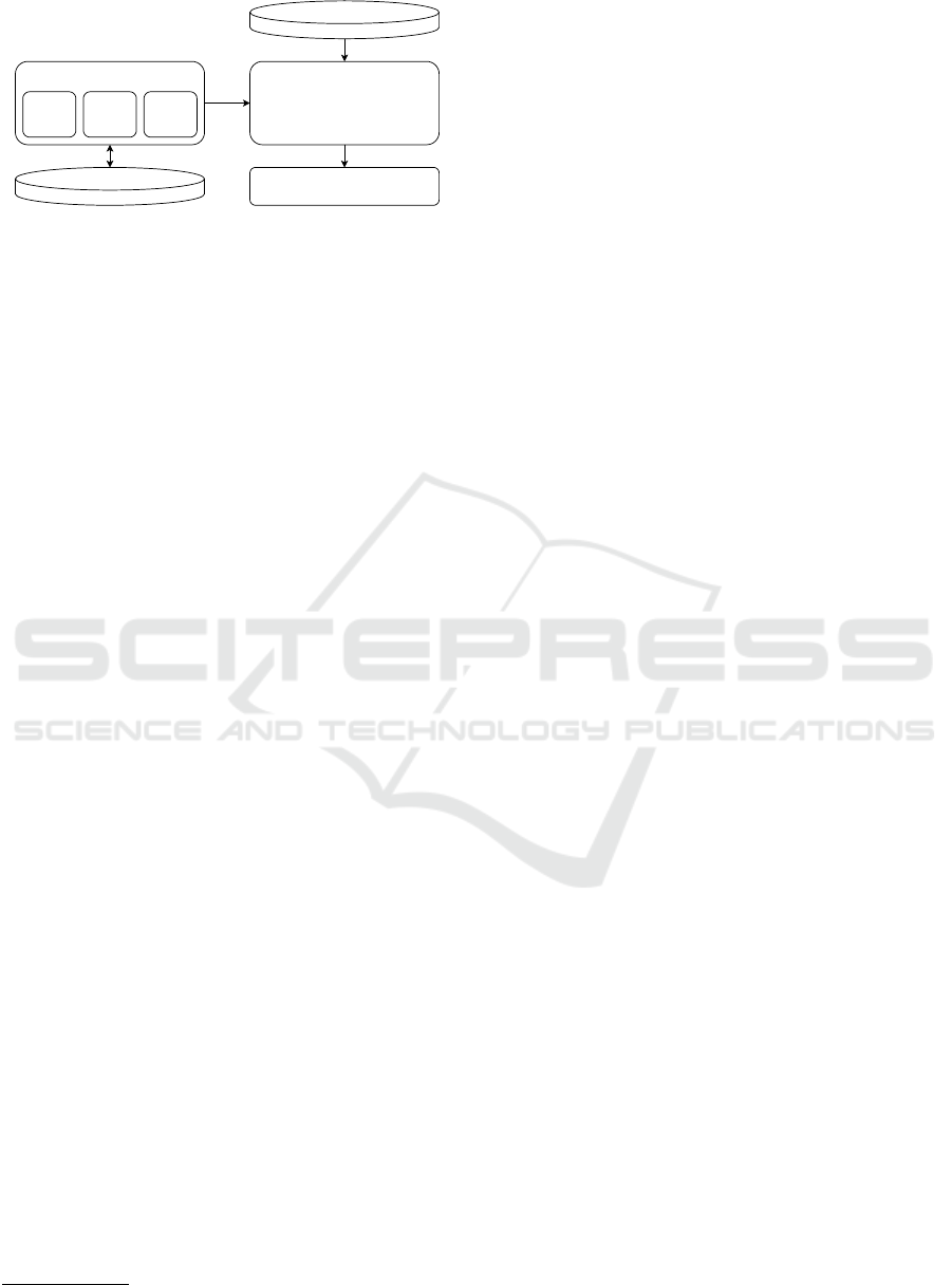
Figure 1: Overview of the system architecture of SEMPR.
maps for long term autonomy in their survey (Kunze
et al., 2018). A rule based reasoner is used by Deeken
et al to infer process phases in agricultural machines
(Deeken et al., 2019). Recently, Crespo et al surveyed
a growing number of approaches to semantic naviga-
tion by using semantic maps with reasoning methods.
The focus, however, still lies on using semantic in-
formation for human-robot-interaction and exploiting
high level information for room recognition and clas-
sification (Crespo et al., 2020).
In this work we use rule based reasoning over a se-
mantic map of an agricultural deployment site to infer
not where the robot should go but how to act on the
way. Like Deeken et al generated occupancy grids
(Deeken et al., 2015), in our work we generate traver-
sal costs for the whole deployment site which enables
a more precise approach to path planning. In contrast
to the descriptions of indoor scenarios the focus rests
not on objects, but on the properties of free space ar-
eas.
3 SYSTEM DESIGN
3.1 Inferring Robot Control Parameters
The framework we developed to hold the representa-
tion and infer implications for robot control and navi-
gation is called Semantic Environment Mapping, Pro-
cessing and Reasoning (SEMPR)
1
and added as a li-
brary to the robots system.
Its Architecture, also shown in Fig. 1, comprises
of a collection of Entities which make up the known
facts about the environment, the domain specific rules
which define how to infer new knowledge and a
reasoning system to perform the automated infer-
ence. Interfaces to a persistence layer and a SPARQL-
Query-Service enable further usability.
The Entities themselves are made up by a set of
components which encode arbitrary data like geome-
tries, semantic information or transformations. How-
1
https://github.com/sempr-tk/sempr
ever, all semantic information is described according
to the Resource Description Framework which is a
well known format for machine understanding and
reasoning (W3C, 2004).
The Rules facilitate inference in the form if-then.
The inferred information is added to the knowledge
base and can be used to activate robot behaviour,
set control parameters or be used in chained rules.
Knowledge of different types can be combined to en-
able reasoning over geospatial and semantic informa-
tion alike as seen in the example below:
[robotInZone:
(?robot <type> <Robot>),
(?zone <type> <Zone>),
Geometry(?zone ?zoneGeo),
Geometry(?robot ?robotGeo),
geo:intersects(?zoneGeo ?robotGeo)
->
(?robot <inZone> ?zone)]
Which translates to For each entity R ∈ Robots
and each entity Z ∈ Zones, retrieve the respective ge-
ometries G
R
, G
Z
. For each combination where G
R
in-
tersects G
Z
, add the fact that R is in zone Z.
3.1.1 Reasoner
In order to decide which rules need to be triggered
at a time, the inference system makes use of the
RETE pattern matching algorithm (Forgy, 1982): The
textual representation of the rules is parsed into a
graph where every node implements a small check
on the given data. If the check succeeds, the data
is forwarded to its child nodes. The connections be-
tween the nodes thus construct the complex condi-
tions as stated in the rules, while the terminal nodes
implement the rules’ consequences. By also insert-
ing memory-nodes, the pattern matching implements
a trade-off between performance and memory con-
sumption, as they enable an iterative processing of
changes to the knowledge base. Facts that match a set
of conditions are stored in the memory nodes and can
be used as partial matches in subsequent conditions
and effects without re-evaluation. Furthermore, when
retracting facts, only branches with memory nodes
containing them need to be re-evaluated. The whole
graph consists of two parts: The alpha-network, in
which the basic data elements are inspected indepen-
dently of each other, and the beta-network, in which
multiple conditions get combined and more complex
checks can be performed.
ICAART 2022 - 14th International Conference on Agents and Artificial Intelligence
158
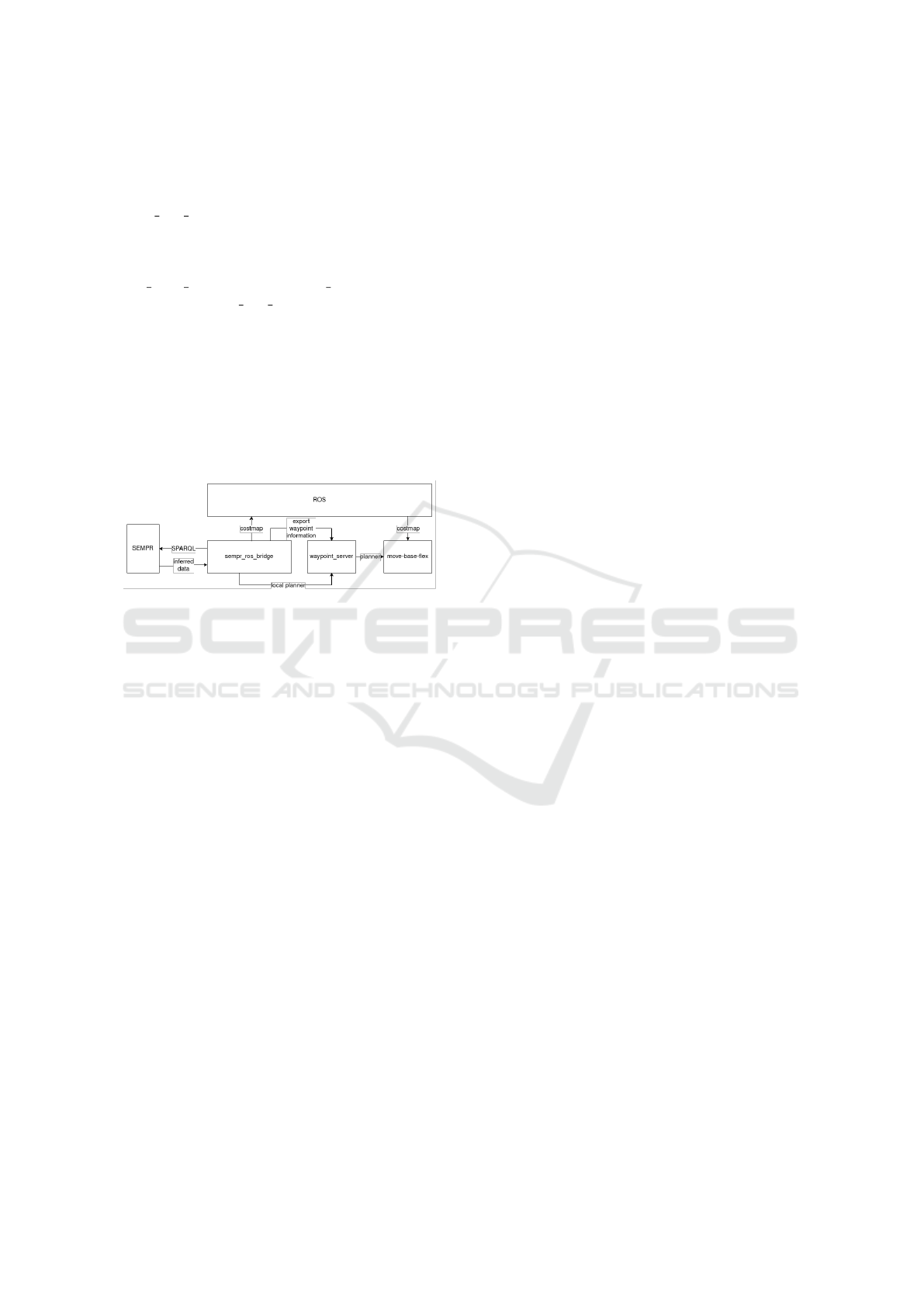
3.2 Robot Control Architecture
For our setup we implement a ROS node called
sempr ros bridge from which a SEMPR instance
is created and managed. The semantic map
and rules are loaded from pregenerated files on
startup. Fig. 2 shows, how the navigation modules
move base flex and waypoint server are con-
nected. The sempr ros bridge node polls updates
from the SEMPR instance in a specified time interval
via the SPARQL Protocol And RDF Query Language
(SPARQL) interface. The resulting information is then
converted into typical ROS message formats and ei-
ther published or introduced to the system in form of
online reconfiguration requests. Additional informa-
tion that the robot could not sense on its own, such
as weather data, can be entered manually directly into
the knowledge base to test the system.
Figure 2: Integration of the reasoning module into a ROS
based system.
3.3 Semantic Parameters for Robot
Control
In our work we concentrated on some central aspects
of robot control and navigation to be inferred by the
rule engine.
3.3.1 Global Path Costs
One very well researched aspect of mobile robots is
the problem of planning a path from one spatial lo-
cation to another in an optimal manner according to
certain variables. Common criteria to be optimized by
a path planning algorithm are the length of the path,
power consumption and the time of traversal, but de-
pending on the domain other considerations might be
of interest: In agriculture, the distribution of strain
to the soil by heavy machinery can be very impor-
tant, as well as to route traffic in a specific way to
ascertain smooth workflows. In robotic practice, dif-
ferent surface properties can have a huge impact on
the drivability of the area. A common way to model
these is the utilization of costmaps: Different cost val-
ues are assigned to discrete grid cells of an area as
a function of the optimization criteria. By assigning
different cost values to discrete grid cells of an area
as a function of the optimization criteria, a shortest
path planning algorithm such as A* or Dijkstra’s can
easily optimize for lowest overall path costs instead
of geometric length only. In that way, more costly
areas such as grass or soil are only crossed by the
robot if the routes are significantly shorter than routes
only traversing better suited surfaces like pavement.
Naively, it is possible to assign traversal costs in this
way to all areas of the map and thus model the de-
ployment environment of the robot. However, such a
static approach meets its limits as soon as the input
parameters to the cost function change. For exam-
ple, the drivability of unsealed surfaces such as soil
or grassland change drastically depending on whether
the surface is wet or dry. By modelling static knowl-
edge about the surface properties of the environment
and according rules, we can infer the costs to tra-
verse a certain area during runtime and thus gener-
ate a costmap dynamically with the logical rules mod-
elling the function to calculate the costs of traversing
a given area given the input variables at the time. In
our experiment we defined traversal costs for discrete
values of very low, low, medium, high and very high.
Those values then would be assigned to regions of the
map according to rules, taking into account the sur-
face type and overall ground wetness to demonstrate
the dynamic generation of a 2D costmap.
3.3.2 Fences and Gates
On a farm where animals are kept and moved between
different places, fences and gates play a large role.
While only few gates can be opened by the robot it-
self right now, it is very plausible that there might
be automated systems opening the gates mechanically
integrated in the future. At the moment, however, it
would already be useful if the robot knew which gates
were open or closed at a given time. In practice some
gates’ open/closed state or probabilities thereof can in
fact be derived from certain knowledge like the time
of day or information about the whereabouts of the
animals. If a gate is known or reasoned to be open
it can be represented in the static map layout, which
updates whenever the state of a gate changes.
3.3.3 Local Path Planning Algorithms and
Driving Speeds
Typical navigation stacks found in robots based on
ROS use a local planning module in addition to the
global path planning. It takes into account locally
observed obstacles, the kinematics of the robot as
well as strategies to account for smooth motor con-
trol. State of the art are multiple approaches of high
quality local planners such as dwa (Fox et al., 1997),
Online Inference of Robot Navigation Parameters from a Semantic Map
159
teb (Roesmann et al., 2012) and eband (Quinlan and
Khatib, 1993). However, experience shows that dif-
ferent planners perform differently in different envi-
ronments. So, in a heterogeneous environment it is
obviously best to choose the planner depending on the
local surroundings. To enable this choice, we mod-
elled the criteria of dynamics which we define as a
scalar between 0.0 and 1.0 to represent the presence of
moving objects in the area the robot is going to cross.
On the extreme value of 1.0, possibly contrary to intu-
ition, it can make sense to choose an algorithm which
sticks closer to the globally planned path and resolves
situations of being blocked by waiting or reevaluation
of the obstacle map instead of trying to locally evade
obstacles which possibly move quicker than the robot
itself. A dynamic value of 0.0 means the robot can
expect to be the only moving object in the vicinity,
which in turn means every obstacle sensed will prob-
ably be static and should be smoothly evaded using a
fitting local planning algorithm.
As a second input parameter we defined the
freespace value to represent the structuredness and
openness of an area. For robotic practice a wide open
field with few to no obstacles blocking sight means
that a local planner can optimize for smooth move-
ments freely without taking moving obstacles into ac-
count that could appear behind occlusions suddenly.
Vice versa, a cluttered environment means that the
robot should try to stick closely to the global path and
possibly reduce driving speeds to accommodate the
fact that obstacles might only become visible when
already close to the robot. These control parameters,
like maximum velocity and the used planning algo-
rithm, can be inferred from the semantic state of the
environment for the different zones with respect to
their aforementioned properties. Their actual geomet-
ric shape and the robots location can also be taken
into account during the reasoning process, as shown
earlier.
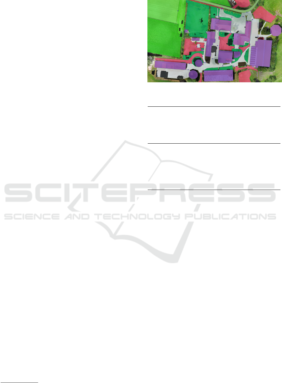
3.4 Modelling of the Semantic Map
To model such a semantic map we model the knowl-
edge as a collection of facts about the domain and a
set of rules which defines allowed inferences. On a
symbolic level this means to have a set of entities rep-
resenting physical or virtual objects of the environ-
ment. Those are associated primarily with geospatial
geometric information as a lot of relevant information
in the agricultural domain revolves around spatial lo-
cations, areas and their extents. We used the open
source tool QGIS
2
to model zones as geospatial vector
polygons in ESRI shape-layers shown in Fig. 3. Each
2
www.qgis.org
Figure 3: Zones as modelled in QGIS.
Table 1: Example data after the postprocessing steps.
id
groundType
freespace
dynamic
animals
1 gravel 0.25 0.4 false
2 gravel 0.7 0.8 false
3 gravel 0.8 0.75 true
4 gravel 0.35 0.2 false
5 gravel 0.15 0.2 false
6 gravel 0.6 0.75 true
zone constitutes a primary semantic entity. The file
format allows to annotate a layer with a table as seen
in Tab. 1 with each row representing a zone. These
are used to model semantic facts which make up RDF
triples with the row as subject, the column name as
predicate and the value of the cell corresponding to
row + column as object. Rules are defined as a pair
of two lists: One for the preconditions and a second
for the assertions. The rules are then stored in a sep-
arate, human readable text file. The shapes and rules
are then imported into the semantic representation and
reasoning module described in section 3.1.
As mentioned before in 3.1, the rules can be con-
sidered to represent logical functions of the input val-
ues which means they can be derived from expert
knowledge using conventional acquisition techniques
like case studies, simulations or structured and un-
structured interviews. An advantage of using a rule
based approach can be seen in the fact that rules can
be naturally formulated as in “traversal costs increase
for certain surface types when the individual wetness
threshold is reached” and then easily translated into
the machine-readable form.
ICAART 2022 - 14th International Conference on Agents and Artificial Intelligence
160
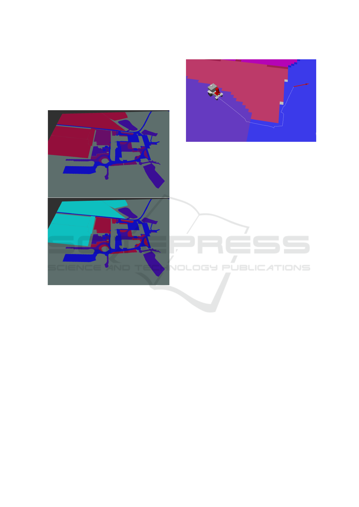
4 RESULTS
Fig. 4 shows two costmaps generated online by the
system. On the top is a generated costmap of the ar-
eas if the condition dry is met as a global condition.
On the bottom a costmap is generated for a moist con-
dition met globally.
Figure 4: Inferred Costmaps: blue, purple, red, turquoise
(low – high). Top: Costs for dry farm condition. Bottom:
Costs for wet farm condition.
As can be seen in fig. 5 the generated costs can be
incorporated in the global costmap of the ros naviga-
tion system and used online for path planning. This
way the navigation behaviour of the robot can be
adapted online according to updates from the reason-
ing process.
Furthermore, the navigation stack of this robotic
system is able to switch between different local plan-
ning algorithms online which additionally offer an
interface to update certain parameters such as maxi-
mum speed and acceleration online via dynamic re-
configure. For example, the data used by the con-
text navigation algorithm shown in (Hoellmann et al.,
2020) can be generated by the semantic control setup.
This way it is possible for the robot to directly infer
important information dynamically during its deploy-
ment. The ability to generate costmaps dynamically
and thus react to changes in weather or other condi-
Figure 5: Robot planning a path according to costmap.
tions can represent real world conditions much more
accurately than any static approach. Likewise can the
inference of choices like local planning algorithms or
movement parameters open up new approaches of in-
telligent robot behaviour. To use a semantic reason-
ing system instead of implicit knowledge encoded in
the programming of the robot allows to identify rules
and facts with the fields respective experts using nat-
urally formulated rule syntax. Decisions made by the
robotic system in this way can be easily explained
and documented due to the explicit modelling of the
knowledge base.
5 OUTLOOK
We showed how a semantic map, that is a represen-
tation of a geographical area with georeferenced sub-
areas, can be annotated in a way to allow efficient in-
ference using known tools like QGIS together with
a reasoning system for geospatial and semantic in-
formation based on the well known RETE algorithm.
With the integration into the ROS ecosystem, this can
be used for the online change of parameters essen-
tial for robotic applications, thus increasing the flex-
ibility with which a robot can adapt to changes in a
complex environment like agriculture. Relevant rules
and facts can be defined using conventional knowl-
edge acquisition techniques with experts. In agricul-
ture it makes sense to organize those rules and facts
around geospatial information, thus being easily ap-
proachable to discuss with experts like farmers.
A further advantage of such a system is to define
knowledge in an explicit way, enabling the robot to
document an explanation for each of its decisions and
profiting of sensing information as well as of prior
knowledge and even inferring from knowledge that
cannot or will not be sensed by the robot.
Future work will include the integration of the in-
ferred information in a live robotic system, replacing
Online Inference of Robot Navigation Parameters from a Semantic Map
161

existing solutions to look up context based control pa-
rameters with the demonstrated inference system. It
appears promising to extend the control parameters
to infer, e.g., covariances for localization filters de-
pending on the traction to expect on certain surfaces
or additional behavioral strategies like acoustic or op-
tical signalling when expecting to act in the vicinity
of humans or animals. Also strategies like not opti-
mizing for shortest paths but instead following right
hand rules when driving along paths or streets might
be beneficial. In a wider perspective the extension
towards probabilistic reasoning appears sensible to
cope with information not easily conveyed with sim-
ple facts.
The generation of fine-grained navigation
costmaps provides the foundation for further work:
As a future avenue we plan to use the semantic
representation to map detected obstacles and annotate
additional information. In the long term there are
many kinds of obstacles which might move in the
scale of minutes, hours or sometimes days. Instead
of just adding them to the costmap and remove them,
once not seen anymore, it might be better to actively
check once a certain amount of time has passed or
not regard them for path planning.
Using semantic reasoning technologies can be an
important contribution to add to the flexibility and
thus robustness of robots expected to act in complex
environments without human supervision. Making
knowledge about the environment explicit can add
to the explainability of artificial intelligent decisions
made by robots as well as to the ease in identifying
relevant rules and facts with the help of experts in the
respective field like agriculture.
ACKNOWLEDGEMENTS
The DFKI Niedersachsen Lab (DFKI NI) is spon-
sored by the Ministry of Science and Culture of
Lower Saxony and the VolkswagenStiftung. The
paper describes work that has been developed in
the context of the funded projects Experimentier-
feld Agro-Nordwest (BMEL, 28DE103E18), DAKIS
(BMBF, 031B0729B) and ZLA (NiMWK, Volkswa-
genstiftung, ZDIN 11-76251-14-3/19).
REFERENCES
Bergerman, M., Billingsley, J., Reid, J., and Henten, E. V.
(2016). Robotics in Agriculture and Forestry. In Sicil-
iano, B. and Khatib, O., editors, Springer Handbook
of Robotics, chapter 56, pages 1463–1492. Springer.
Buschka, P. (2005). An investigation of hybrid maps for
mobile robots. PhD thesis, University
¨
Orebro.
Cosgun, A. and Christensen, H. I. (2018). Context-aware
robot navigation using interactively built semantic
maps. Paladyn, Journal of Behavioral Robotics,
9(1):254–276.
Crespo, J., Castillo, J. C., Mozos, O. M., and Barber, R.
(2020). Semantic Information for Robot Navigation:
A Survey. Applied Sciences, 10(2):497.
Deeken, H., Wiemann, T., and Hertzberg, J. (2019). A
spatio-semantic approach to reasoning about agricul-
tural processes. Applied Intelligence, 49(11):3821–
3833.
Deeken, H., Wiemann, T., Lingemann, K., and Hertzberg,
J. (2015). SEMAP - a semantic environment mapping
framework. In 2015 European Conference on Mobile
Robots (ECMR), pages 1–6. IEEE.
Egerstedt, M., Pauli, J. N., Notomista, G., and Hutchinson,
S. (2018). Robot ecology: Constraint-based control
design for long duration autonomy. Annual Reviews
in Control, 46:1–7.
Forgy, C. L. (1982). Rete: A fast algorithm for the many
pattern/many object pattern match problem. Artificial
Intelligence, 19(1):17–37.
Fox, D., Burgard, W., and Thrun, S. (1997). The dy-
namic window approach to collision avoidance. IEEE
Robotics Automation Magazine, 4(1):23–33.
Galindo, C., Saffiotti, A., Coradeschi, S., Buschka, P.,
Fernandez-Madrigal, J., and Gonzalez, J. (2005).
Multi-hierarchical semantic maps for mobile robotics.
In 2005 IEEE/RSJ International Conference on Intel-
ligent Robots and Systems, pages 2278–2283. IEEE.
Hoellmann, M., Kisliuk, B., Krause, J. C., Tieben, C.,
Mock, A., Sebastian, P., Igelbrink, F., Wiemann,
T., Martinez, S. F., Stiene, S., and Hertzberg, J.
(2020). Towards Context-Aware Navigation for Long-
Term Autonomy in Agricultural Environments. In
2020 IEEE/RSJ International Conference on Intelli-
gent Robots and Systems (IROS), Las Vegas.
Kostavelis, I. and Gasteratos, A. (2015). Semantic mapping
for mobile robotics tasks: A survey. Robotics and
Autonomous Systems, 66:86–103.
Kuipers, B. (2000). The Spatial Semantic Hierarchy. Artifi-
cial Intelligence, 119(1-2):191–233.
Kunze, L., Burbridge, C., Alberti, M., Thippur, A.,
Folkesson, J., Jensfelt, P., and Hawes, N. (2014).
Combining top-down spatial reasoning and bottom-
up object class recognition for scene understanding.
In 2014 IEEE/RSJ International Conference on Intel-
ligent Robots and Systems, pages 2910–2915. IEEE.
Kunze, L., Hawes, N., Duckett, T., Hanheide, M., and Kra-
jnik, T. (2018). Artificial Intelligence for Long-Term
Robot Autonomy: A Survey. IEEE Robotics and Au-
tomation Letters, 3(4):4023–4030.
Lang, D. and Paulus, D. (2014). Semantic Maps for
Robotics. In Proceedings of the Workshop on AI
Robotics at the IEEE International Conference on
Robotics and Automation.
Langley, P., Meadows, B., and Sridharan, M. (2017). Ex-
plainable agency for intelligent autonomous systems.
ICAART 2022 - 14th International Conference on Agents and Artificial Intelligence
162

In IAAI ’17 proceedings of the twenty-ninth AAAI con-
ference on innovative applications of artificial intelli-
gence, pages 4762–4763.
N
¨
uchter, A. and Hertzberg, J. (2008). Towards semantic
maps for mobile robots. Robotics and Autonomous
Systems, 56(11):915–926.
Pronobis, A. (2011). Semantic Mapping with mobile robots.
PhD thesis, KTH.
Putz, S., Santos Simon, J., and Hertzberg, J. (2018). Move
Base Flex A Highly Flexible Navigation Framework
for Mobile Robots. In 2018 IEEE/RSJ International
Conference on Intelligent Robots and Systems (IROS),
pages 3416–3421. IEEE.
Quinlan, S. and Khatib, O. (1993). Elastic bands: con-
necting path planning and control. In Proceedings
IEEE International Conference on Robotics and Au-
tomation, pages 802–807 vol.2.
Roesmann, C., Feiten, W., Woesch, T., Hoffmann, F., and
Bertram, T. (2012). Trajectory modification con-
sidering dynamic constraints of autonomous robots.
In ROBOTIK 2012; 7th German Conference on
Robotics, page 74–79.
Shamshiri, R. R., Weltzien, C., A. Hameed, I., J. Yule, I.,
E. Grift, T., K. Balasundram, S., Pitonakova, L., Ah-
mad, D., and Chowdhary, G. (2018). Research and
development in agricultural robotics: A perspective of
digital farming. International Journal of Agricultural
and Biological Engineering, 11(4):1–11.
W3C (2004). Resource Description Framework. https://
www.w3.org/RDF/.
Online Inference of Robot Navigation Parameters from a Semantic Map
163
