
Hierarchical Terrain Representation and Flood Fill-based
Computation of Large-Scale Terrain Changes for
Agent-based Simulations
Luis A. L. Silva
1,2 a
, Evaristo J. Nascimento
1,2 b
, Eliakim Zacarias
2c
, Raul C. Nunes
1,2 d
and Edison P. Freitas
2,3 e
1
Graduate Program in Computer Science, Federal University of Santa Maria, Av. Roraima 1000, Santa Maria - RS, Brazil
2
SIS-ASTROS GMF Project, Federal University of Santa Maria, Av. Roraima 1000, Santa Maria - RS, Brazil
3
Informatics Institute, Federal University of Rio Grande do Sul, Av. Bento Gonçalves 9500, Porto Alegre - RS, Brazil
edisonpf@gmail.com
Keywords: Dynamic Terrain, Hierarchical Terrain Representation, Flood Fill Computation, Agent-based Simulation.
Abstract: Modern virtual training benefits from the recent advances in Agent-Based Modelling and Simulation
(ABMS), making it possible to use real-world dynamic terrain scenarios that enhance the users learning
from agent-based simulations. An important issue for distributed ABMS systems is the possibility of using
terrain services that promptly compute large-scale terrain map changes as a result of natural phenomena
such as river floods and wildfires. Performing the alterations in terrain maps is challenging since they de-
pend on the combination of terrain features and terrain sizes. To address this problem, this work proposes
the use flood fill-based techniques along with the hierarchical QuadTree approach for the terrain representa-
tion. We show that these techniques are essential to promptly compute the effects of the changes on a large
number of nodes of the hierarchical map representation that captures the terrain features in different levels
of detail. Also, a way to store and recover the QuadTree nodes in/from a dictionary-based memory is pro-
posed, improving the nodes’ refinement and restoration process when the terrain changes are required on the
simulations. Experiments with the proposed techniques show encouraging results, with reduced computing
times considering terrains with different characteristics and numbers of alterations.
1 INTRODUCTION
abcde
Agent-Based Modelling and Simulation (ABMS)
(Macal 2016) is a valuable paradigm for virtual
training and instruction in different application do-
mains. One of the main ABMS challenges is the
development of realistic simulations with non-static,
large-scale, and real-world terrain environments.
Relevant instances of the need for such virtual sce-
narios involve the simulation of flooding effects in
large urban areas (Liang, Du et al. 2008) and the
simulation of wildfires (Rui, Hui et al. 2018). Moti-
vated by these complex phenomena, this work inves-
a
https://orcid.org/0000-0002-6025-5270
b
https://orcid.org/0000-0002-2388-895X
c
https://orcid.org/0000-0001-7988-4141
d
https://orcid.org/0000-0003-3228-4071
e
https://orcid.org/0000-0003-4655-8889
tigates the problem of implementing optimized tech-
niques to compute the impact of these events on
large areas of the hierarchical topology of the repre-
sented terrain maps. The possibility of modelling
large-scale terrain map representations that can be
extensively modified due to the effects of these
phenomena is a key component for the simulation of
multi-agent global and local realistic agent behav-
iours. With the terrain structure and a capability of
modifying it, the agents have to sense the changing
real-world terrain characteristics to (re)plan their
tactical and strategic movement actions. The
changeable nature of the represented terrain regions
along with the targeted terrain attributes, whether
they can be sensed by the agents either as obstacles
or not, has a crucial impact on the resulting agents’
models. An important aspect is the fact that the
computations supporting these changes may impair
the fluency and realism of the simulations if conven-
Silva, L., Nascimento, E., Zacarias, E., Nunes, R. and Freitas, E.
Hierarchical Terrain Representation and Flood Fill-based Computation of Large-Scale Terrain Changes for Agent-based Simulations.
DOI: 10.5220/0011134800003274
In Proceedings of the 12th International Conference on Simulation and Modeling Methodologies, Technologies and Applications (SIMULTECH 2022), pages 15-25
ISBN: 978-989-758-578-4; ISSN: 2184-2841
Copyright
c
2022 by SCITEPRESS – Science and Technology Publications, Lda. All rights reserved
15

tional regular grid-based map representations and no
other advanced technologies are used, thus negative-
ly impacting the systems’ responsiveness (Nielsen
1994) and the desired agent-based simulation real-
ism.
From a preliminary discussion presented in
(Nascimento, Zacarias et al. 2019) and the proposi-
tion of a distributed service-oriented multi-agent
simulation architecture in which the proposed tech-
niques are inserted as terrain simulation services, the
contributions of this work are:
(1) The hierarchical approach to efficiently rep-
resent real-world terrain maps for agent-based simu-
lations. To enable the development of simulations
running over large-scale dynamic terrain maps cap-
tured in different levels of representation detail, this
work proposes the use of a hierarchical QuadTree
representation (e.g. (Brondani, de Lima Silva et al.
2019)) to store data used to compute changes caused
by the effects of dynamic events. This work inno-
vates by proposing the use of this representation to
allow the optimized computation of the changing
effects due to simulated natural phenomena in the
terrain map;
(2) The use of Flood Fill-based techniques (also
known as Seed Fill algorithms (Glassner 1990)) to
execute extensive changes in the QuadTree. With
that, the general consequences of river floods and
wildfires, for instance, are represented on large areas
of the terrain maps. The implemented algorithms
guide the advance and retreat of the river floods and
the wildfires, and the efficient blocking and releas-
ing of nodes processed by the simulated agents’
algorithms;
(3) The proposition of a dictionary-based
memory for the storage and the restoration of not
only the nodes but also the branches of the Quad-
Tree that were subjected to the terrain changes. The
proposed solution explores the changing of terrain
map areas that should not simply be lost/not proper-
ly reused after they were processed. That is because
the restoration of the hierarchical terrain structure to
alternative representation states has a meaningful
impact on the realistic execution of agents’ planning
and navigation tasks.
(4) The analysis of different kinds of tests to as-
sess the enhanced performance of the proposed
techniques. The tests present computing time results
for increasing levels of changes due to river floods
and wildfires in three different real-world terrain
map models. The results are obtained with the use of
the QuadTree representation approach, and they are
contrasted with similar testing results obtained when
a regular grid structure is used in the same maps.
2 BACKGROUND AND RELATED
WORK
The exploration of irregular map representation
topologies (Algfoor, Sunar et al. 2015) for the mod-
elling of virtual terrains is important for the devel-
opment of simulation systems to real-world applica-
tion problems. While the regular grids with repre-
sentation nodes of the same size are often used in the
capture of small-scale terrains mostly for computer
games, the irregular grids are formed by nodes with
distinct dimensions and shapes.
To capture real-world terrain areas in the simula-
tion system, map cells are often modelled according
to information extracted from real-world GIS-based
maps. Depending on the level of detail that such
maps are produced, the storing and use of such ter-
rain features usually results in a high computational
cost for the Artificial Intelligence (AI) algorithms
supporting the agent simulations. This is true not
only when one considers the simulated agents and
their relationships but also when such costs are due
to the “Environment-Environment” interactions
(Hawe, Coates et al. 2012) between the simulated
terrain objects.
Simulations based on dynamic terrain scenarios
have a highly positive impact on the quality of the
simulation-based training activities in many applica-
tion problems. For instance, (Pfeiffer and Tamash
2014) describe a system that allows the simulation
of combat operations. They seek to explore the real-
ism in the physics of the simulated environment, the
use of climate changes and their effects, leading to
operational problems to be approached by the agents
deployed in the virtual scenario. Simulated natural
phenomena are presented in (Liang, Du et al. 2008),
where the algorithms simulate rescue situations due
to terrain floods. Once the terrain changes occur in
the map structure, simulated agents (and users who
may be in control of these agents) are prompted to
take new decisions along with the development of
the simulations. An algorithm to model the propaga-
tion of wildfires is presented in (Rui, Hui et al.
2018). This algorithm is applied to a non-
hierarchical grid structure that represents the virtual
terrain. The grid cells capture state information to
represent the cell situation (e.g. its burning state).
Computational techniques to dynamic virtual (syn-
thetic) environments are presented in (Smelik, van
Wermeskerken et al. 2018). To build these dynamic
terrains, a set of constraints are considered: perfor-
mance when working with terrains in different levels
of representation detail, simulation realism and con-
trol of dynamic events occurring in the terrain envi-
SIMULTECH 2022 - 12th International Conference on Simulation and Modeling Methodologies, Technologies and Applications
16

ronment, among others. Examples of terrain defor-
mations are the trails left by vehicles, the erosion
effects caused by heavy rains or river dam ruptures,
the explosion of buildings and bridges, and others.
All these events can have an impact on the terrain
representation, and the consequent computations
guiding the simulation of various kinds of agents’
movement behaviours.
Among the works that explore the hierarchical
representation of the terrain structure, the Dynamic
Probabilistic QuadTree technique is described in
(Cocaud and Jnifene 2010). There, each node con-
tains information about the probability of an obstacle
being located in it. The QuadTree node expansion
and shrinking operations are based on the alteration
of the probability value of the nodes affected by the
computed terrain changes. (Liang, Du et al. 2008)
explore the adaptive QuadTree representation in the
modelling of the surface water runoff due to floods.
In (Wouter G. van Toll, Atlas F. Cook IV et al.
2012), the costs due to the computation of alterations
in virtual terrain structures are investigated. The
situations that modify the virtual terrain map are the
insertion of obstacles in the form of point, line, or
polygon, where all of them consider the polygonal
characteristics of the NavMesh representation struc-
ture. All in all, these works discuss techniques that
support the modification of the represented terrain
topology. However, they mostly focus on the analy-
sis of small-scale and almost always local terrain
changes while many real-world simulations ought to
be based on large-scale terrain areas in which the
topology of the represented world could change
significantly over short periods of time.
3 THE SIMULATION SYSTEM
ARCHITECTURE
The proposed architecture for the simulation system
(Fig. 1) is based on a distributed service-oriented
multi-agent approach in which simulation services
are used by simulation systems’ clients over the web
(Byrne, Heavey et al. 2010). At its core, there is a
Terrain Simulation Server that receives as input real-
world GIS-based terrain maps to create a virtual
model for the various levels of represented terrain
information. This is a process that generates the
various navigation maps for the simulated real-world
terrains.
To develop dynamic terrain simulation services
to equip this simulation proposal, this work focuses
on the representation and prompt modification of the
structure of the terrain navigation maps used to
guide the agent-based simulations. While the terrain
representation structure by itself can be indexed by
different representation layers, such layers have the
overall aim of capturing the targeted terrain features
for the simulation purposes. Then these features are
hierarchically represented to optimize the computa-
tions of the simulation exercises. With that, the sta-
tus of the altered terrain map attributes is distributed
to/shared by the Simulation Clients, where terrain
scenarios can be visualized in different forms by
these client implementations.
The architecture is composed of core components
supporting the large-scale terrain representation and
the basic functionalities for the terrain map manipu-
lation. The Hierarchical Terrain Representation
component, which is implemented as a QuadTree, is
responsible for the basic elements that compose the
terrain navigation map. The hierarchical and irregu-
lar grid topology of the QuadTree allows the opti-
mized representation and computation of large-scale
maps. In it, the deeper the node is, the higher the
level of terrain representation detail is. The use of
this topology allows refining the representation
structure to capture the terrain features of interest for
the simulations, where alternative features can be
considered: the shapes of the terrain landscape, the
steepness of these terrain features, and the location
of rivers and other bodies of water, among others.
The component capturing the Terrain Simulation
Algorithms is responsible for providing the basic
algorithms to the management of the elementary
parts of the terrain structure, i.e. the nodes that rep-
resent the hierarchical terrain map. These algorithms
are used to implement specific Simulation Services
that provide large-scale changes in the terrain map,
such as blocking/releasing nodes affected by river
floodings and wildfires. In the proposed approach,
the alteration of terrain representation structure is
computed according to a set of reusable flood fill-
based operations. It means that the computing tech-
niques regarding graph flooding are explored to
guide the analysis and alteration of the represented
areas (nodes) of the terrain map. Such procedures
are directed by the QuadTree refinement, resulting
in the expansion and retraction of the hierarchy
levels. Similarly, terrain restoration operations are
implemented, aiming to return the QuadTree struc-
ture to its previous state. The restoration procedures
can also be concerned with the maintenance of the
altered QuadTree nodes, which are saved into and
retrieved from a Dictionary-Based Memory.
The Dictionary-Based Memory manages terrain
information that is redundant to the QuadTree.
Hierarchical Terrain Representation and Flood Fill-based Computation of Large-Scale Terrain Changes for Agent-based Simulations
17
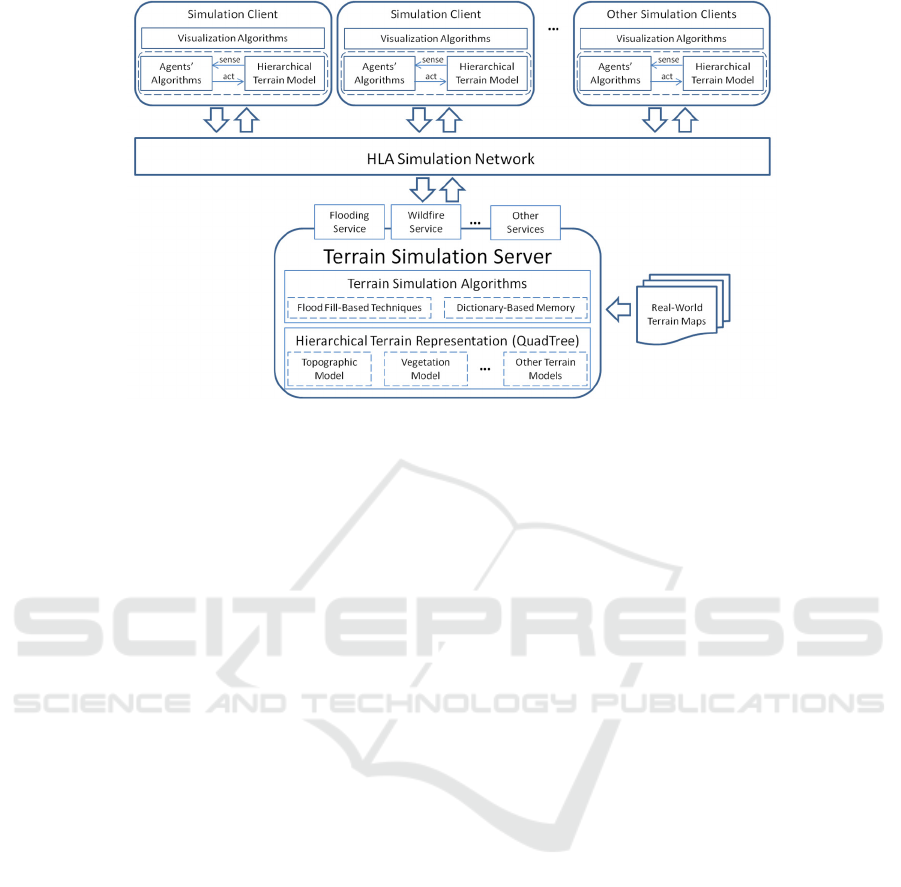
Figure 1: A distributed service-oriented multi-agents’ simulation architecture.
However, it allows the implementation of simu-
lation terrain services that permit executing efficient
expansion and retraction operations on the hierar-
chical terrain map representation. In practice, the
terrain information leaves the QuadTree when the
changes in the terrain map nodes are materialized.
So the degree of terrain detail represented in the
QuadTree is reduced. Despite the fact the simulated
terrain map ends up being represented in a lower
granularity, the modified terrain map information is
maintained in the dictionary for future (re)use. In
later computations with it, the changed terrain in-
formation doesn’t need to be searched in the Quad-
Tree. This memory is implemented as a HashTable
organized as tuples (key, value), where a query to it
can be executed. This query retrieves the represented
QuadTree nodes (or entire subtrees) changed due to
the simulated natural phenomena. That restoration
also permits the reconstruction of the QuadTree in
different forms.
Several Simulation Clients can access the Simu-
lation Services provided by the above-described
server via a HLA Simulation Network (e.g. (Lees,
Logan et al. 2006)). At each client, a multi-agent
simulation engine operates over the locally stored
hierarchical representation of the simulated terrain
map, sensing and acting on it. The simulated agents
implement different types of algorithms, e.g. global
and local path planning, which need to collect data
from the simulated environment. Then they select
the best course of actions to perform a given realistic
agent behaviour in the targeted simulations. In prac-
tice, a Hierarchical Terrain Model component cap-
tures a view of the terrain map data at the clients’
systems, and uses the Simulation Services provided
by the Terrain Simulation Server to perform large-
scale changes in the hierarchical structure that com-
pose the map. These changes affect the perception of
the environment sensed by the simulated agents,
thus also their actions. They can also guide the visu-
al appearance of the simulated environment which is
presented by the alternative Visualization Algo-
rithms implemented in each Simulation Client.
The structural changes on the hierarchical terrain
representation analyzed in this work are motivated
by the advance and retreat of floods along
riverbanks and the terrain changes occurring due to
wildfires. Those changes are computed in different
representation layers of a simulated terrain. In prac-
tice, while the simulations are running in this dy-
namically changing environment, for instance, the
simulation instructor can insert these events into the
simulation exercises. Such action can cause agents’
evasive actions to avoid the flooded areas, the con-
struction of river dams, and the development of
other mitigation tasks in the simulations. As ap-
proached in this work, similar agents’ re-planning
computations can also be required due to large-scale
wildfires. From the dynamic nature of the used
simulation scenarios, practical experience with
simulations indicates that users of the implemented
simulation systems can be subjected to multi-agent
tactical and strategic simulation problems to im-
prove their decision-making capabilities.
SIMULTECH 2022 - 12th International Conference on Simulation and Modeling Methodologies, Technologies and Applications
18

4 REPRESENTATION AND
COMPUTATION OF
LARGE-SCALE TERRAIN
CHANGES
In the construction of the QuadTree, the terrain
height feature can be used in the process of subdi-
viding the hierarchical representation in its different
levels can be explored (see examples of it in Fig. 1-
3). There, relief heights are captured in different
levels of detail. In doing so, there is an “inheritance”
of terrain height values from the father to the child
nodes, where the child nodes just refine the maxi-
mum and minimum terrain heights represented at the
father node. A new level in the QuadTree hierarchy
is built whenever one of these terrain features is
identified in the analysis of the used real-world GIS-
based maps. This process is repeated until the final
QuadTree refinement condition is met. In the end,
the irregular representation of the terrain is ex-
pressed by QuadTree “leaf” nodes.
To model the terrain map structure, a directed
graph is captured as a Tree <n, maxLevel, root>.
There, a QuadTree node n consists of n <parent,
children, level, isLeaf, refined> such that n.parent
and n.children are pointers used by the hierarchy;
n.level indicates the level of the hierarchy to which
the node n belongs to; n.isLeaf indicates whether the
node is a leaf, and n.refined indicates that new nodes
were generated from the node n on a temporary
basis. Tree.maxLevel indicates the maximum hierar-
chical level where the irregular grid is captured by
the QuadTree leafs. Attributes required for the com-
putation of terrain effects due to river floods and
wild fires are modeled as n <minHeight, maxHeight,
neighbors, hasRiver, walkable, flooded, vegeta-
tionDensity, burned> such that n.minHeight and
n.maxHeight capture the minimum and maximum
terrain height values inside the terrain region repre-
sented by the node n; n.neighbors consist of a list of
neighbor nodes of node n, permitting to capture the
connection between the adjacent nodes; n.hasRiver
indicates the presence of rivers in the terrain area
covered by node n; n.walkable indicates whether the
node n is navigable by simulated agents; n.flooded
indicates whether the node n was subjected to terrain
alterations as a result of the flood fill-based compu-
tations;. n.vegetationDensity indicates the amount of
trees inside the terrain region represented by the
node n; and n.burned indicates whether the node n
was subjected to the fire alterations.
The use of the flood fill-based technique along
with this QuadTree representation occurs as follows.
An initial node is removed from a control queue.
Then the flooding test is performed on it. This per-
mits to identify (un)blocked nodes that satisfy a
“flooding condition”. Such nodes can be blocked for
the terrestrial agent movement, where the condition
for it is that (a) the terrain node represents a relief
height below a certain flood-prone height (i.e. a river
flood limit) and (b) the node captures a terrain re-
gion that is located next to the course of rivers. In
doing so, the algorithm considers the maximum and
minimum terrain relief heights. These are there in
each QuadTree node as shown in Fig. 2 (this figure
illustrates some of the steps of the proposed solution
through an example of a 5m river flood).
The neighbouring nodes of a flooded one are
analyzed. When it happens, the flood limit can be a)
above the maximum terrain height, b) below the
minimum terrain height, and c) between the maxi-
mum and minimum terrain height. The nodes with
maximum terrain heights below the flood limit are
identified and added to the control queue. A node is
removed from this queue and the algorithm checks
whether its parent also meets the flooding condition.
If so, further parent nodes upwards in the hierarchy
are tested.
This process continues until a QuadTree node not
meeting the flooding condition is found. With the
non-leaf node satisfying the condition, the subtree
rooted on it is removed from the QuadTree. Then it
is added to the dictionary. The flooded node is trans-
formed into a leaf one. That ends expressing a larger
flooded terrain area in the QuadTree. This process
stops when the control queue is empty. As an exam-
ple, in Fig. 2, the subtree rooted on node 2 is memo-
rized into the dictionary and the QuadTree structure
is simplified after this process.
The restoration of the terrain structure consists of
rebuilding the QuadTree to a targeted state. For
instance, the reconstruction allows simulating the
return of the flooded water to the original river bed.
When analyzing an altered node, the algorithm
checks whether it was previously refined. For exam-
ple, large terrain areas could have been subdivided
in smaller pieces, where only a few of these subareas
were flooded. To do so, the alteration algorithm
checks the “refined’ attribute represented in the
QuadTree node. If the node was refined, the restora-
tion procedure carries out the (re)grouping of the
terrain representation nodes generated due to the
QuadTree refinement.
The terrain structure can also be returned to a
partial representation state, permitting to compute
the partial flood retreat, for instance. This occurs
when the restoration condition allows a portion of
Hierarchical Terrain Representation and Flood Fill-based Computation of Large-Scale Terrain Changes for Agent-based Simulations
19
Figure 2: River flood alteration steps computed in the QuadTree: (a) and (d) the 5.0m river flood is above the relief height
represented by the node; (b) and (e) this flood is also above the height represented by the parent node; (c) and (f) all the
terrain area covered by the parent node is flooded – a single larger size and blocked terrain area is represented in the Quad-
Tree; (g) the flooded subtree is saved in the dictionary.
the terrain structure not to be restored, while other
parts of it are kept into the dictionary.
The restoration can also result in the generation
of new terrain subareas (i.e. new nodes in the Quad-
Tree). That is because the computed flooding may
have caused the grouping of these terrain nodes,
where this grouping ended expressing a single larger
terrain area in the QuadTree representation. To re-
store terrain subareas from the dictionary, the node
that rooted the affected subtrees is used. It is kept in
the QuadTree even after the terrain changes were
computed, guiding the search of a desired terrain
subarea stored in the dictionary.
As illustrated in Fig. 3, the algorithm analyzes
the minimum and maximum heights of each restored
node from the dictionary. If the maximum height
recorded in these nodes is below the flood retreat
level, the nodes remain blocked. Otherwise, if the
minimum height is above the retreat level of the
flooding, the nodes are defined as unblocked.
In the process of releasing flooded nodes, when
the node under review has a subtree stored in the
dictionary, that subtree is restored and included in
the QuadTree. After restoring the node in which the
flooding retreat level is between the maximum and
minimum terrain relief heights, it is necessary to
refine that node to examine its possible children.
These terrain subareas can have a maximum height
below the flooding retreat level, indicating that they
should be blocked for terrestrial navigation. And if
they have a minimum height above the flooding
retreat level, they are set up as unblocked. Such
refinement is also developed as long as the maxi-
mum QuadTree refinement level is not reached.
The aimed vegetation characteristics of a simu-
lated real-world terrain can also be represented in
the QuadTree. Similar to the terrain relief represen-
tation, the hierarchical representation is used in the
indexed generation of the vegetation layer for the
simulated terrain. The computation of changes in the
terrain representation structure as to express the
effects of wildfires makes use of the numerical value
representing vegetation density characteristics in the
QuadTree. When a parent node representing a ter-
rain area has a certain vegetation density, its children
nodes may not capture the same density represented
by its parent. That is because such vegetation can be
localized in a smaller subarea of the entire area cov-
ered by the parent node. Therefore, to change the
blocking status of an internal QuadTree node due to
wildfire effects, it is necessary to analyze all chil-
dren nodes from the current one.
SIMULTECH 2022 - 12th International Conference on Simulation and Modeling Methodologies, Technologies and Applications
20
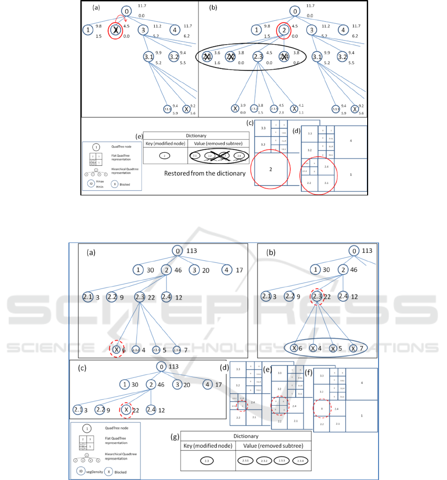
Figure 3: Restoration steps in the QuadTree: (a) and (c) the 1.0m river flood retreat is below the relief height represented by
the flooded node; (b) and (d) the flooded subtrees are restored from the dictionary: one of these subtrees returned to its
original state, and the other three remained flooded – they represent larger-size and blocked terrain areas in the QuadTree.
Figure 4: Wildfire alteration steps computed in the QuadTree: (a) and (d) a vegetation density (e.g. 10) permitting the cur-
rent wildfire propagation is higher than the density represented on the leaf node (e.g. a fire ignition point); (b) and (e) this
density is not higher than the one represented by the parent node; (c) and (f) all the terrain area covered by the parent node
is blocked due to the wildfire; (g) the subtree rooted on the parent node is saved in the dictionary.
Different from the river flooding computations, the
QuadTree alterations due to wildfire effects are
implemented as a bottom-up procedure. The algo-
rithm starts at a certain terrain location representing
an initial fire ignition point (see Fig. 4). Then it
examines the neighbouring nodes of the first node
affected by the fire. Nodes that satisfy the wildfire
condition are added to the queue that controls the
algorithm execution. A node is removed from the
queue, and it is marked as burned. Then, the algo-
rithm checks whether all siblings of the current node
have been marked as burned. If so, the node along
with its siblings are removed from the QuadTree,
and their parent node is marked as burned. Then this
Hierarchical Terrain Representation and Flood Fill-based Computation of Large-Scale Terrain Changes for Agent-based Simulations
21

parent is turned into a leaf node. In addition, it is
analyzed whether all the siblings of the node turned
into a leaf are burned. When these siblings capture
larger terrain areas, these nodes are refined and the
smaller ones are added into the QuadTree. It hap-
pens whenever the maximum QuadTree refinement
level is not reached. If all these children nodes satis-
fy the fire propagation condition, the parent node is
marked as burned and the QuadTree refinement is
undone. Otherwise, only the children nodes satisfy-
ing the wildfire condition are blocked.
The analysis continues until the algorithm does
not find a node in which its siblings have been sub-
jected to fire. Unlike the retreat of river floods, we
have not implemented a short-term natural phenom-
enon regarding the restoration of the terrain structure
from the wildfire effects. However, it is possible to
restore the terrain representation map to the state
prior to the computation of the wildfire changes,
restoring all the performed QuadTree refinements.
5 EXPERIMENTS AND RESULTS
The goal of the experiments was to analyze the ef-
fort to compute structural alterations in the Quad-
Tree used in the representation of different terrains.
The following terrains were used: terrain (A) with
64 km² and a QuadTree with 10 levels, terrain (B)
with 256 km² and a QuadTree with 11 levels and
terrain (C) with 1024 km² and a QuadTree with 12
levels. In all tested terrains, the deepest “leaf” nodes
in the QuadTree represent a real-world terrain region
of approximately 64 m². For comparison purposes,
versions of each terrain were represented with the
use of a regular grid structure with 64 km², 256 km²,
and 1024 km², where grid cells capture terrain re-
gions with approximately 1024 m². The terrain struc-
tures used in the tests have an increasing number of
areas that are susceptible to changes caused by river
floods and wildfires. In this case, 8%, 16%, and 32%
of the total area of these terrains have areas covered
by rivers, while 16%, 31%, and 64% of their areas
are covered by forests. Different levels of floods
were used in the experiments: 2.5m and 5.0m above
the level of the represented rivers. Similarly, differ-
ent wildfire burning effects were computed in these
terrain structures. Finally, the relief characteristics
and the distributions of fire-prone areas (i.e. forests)
in the tested terrains are different, where the larger-
size terrains are not simply larger versions of the
smaller ones. This should be noted when drawing
conclusions from the test results. The algorithms
were executed 50 times in each test scenario. The
tests were executed in the Unity 3D engine (Unity
Technologies 2018). With many relevant industrial
applications, that is the engine used in the develop-
ment of computer games and simulation systems. An
Intel I7 4790 processor with 10 GB RAM was used
to perform the experiments.
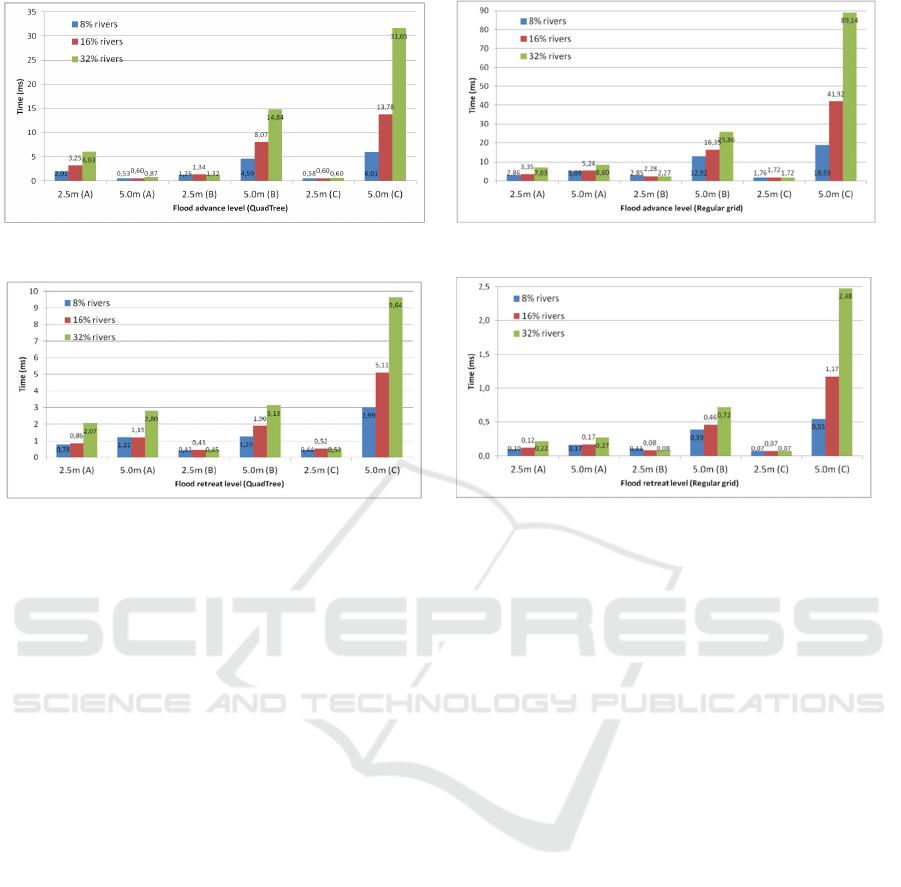
Regarding the advance of the river floods, the
highest computing time to execute the terrain struc-
ture alteration algorithms was 31.65ms with the
QuadTree and 89.14ms with the regular grid (Fig.
5). Thus the execution time of the algorithms with
the QuadTree was much lower than the time re-
quired to performing similar alterations with the
regular grid. This is mostly due to the blockage of
internal QuadTree nodes as a consequence of the
floods, causing the blockage of a larger number of
“leaf” nodes (when blocking a root node of the
QuadTree, its children are also blocked). This hap-
pens when all children nodes represent terrain areas
with relief elevations below the flood level being
computed.
Regarding the retreat of the floods, the highest
computing time was 9.64ms with the QuadTree and
2.48ms with the regular grid (Fig. 6). Although the
retreat of the floods with the QuadTree presented a
higher computing time than with the regular grid, the
computation of the flood retreat consequences was
much slower than the computations for the advance
of the floods.
First, tests were performed to assess the river
flood advance computations. For the 2.5m and 5.0m
flood advance computations (Fig. 5), the time to
compute the 2.5m flood consequences was smaller
than the time for computing 5.0m flood effects. That
was observed when both the QuadTree and the regu-
lar grid structures were used. In case of small ampli-
tude floods (i.e. 2.5m), the execution of the imple-
mented algorithms show that most of the time the
nodes analyzed are adjacent to the ones representing
the rivers, where small-size affected areas do not
require the analysis of the internal nodes of the
QuadTree (i.e. the nodes representing larger pieces
of terrain). Thus the floods affecting small areas of
the terrain structure do not result in a thoughtful
exploration of the QuadTree hierarchy, increasing
the execution time of the algorithms. That did not
happen when the 5.0m floods were computed in the
terrains (B) and (C). However, there are exceptions
to this pattern: due to the topography of the terrain
(A), the time to compute 5.0m flood effects in it was
smaller than the time to compute similar 2.5m
floods.
SIMULTECH 2022 - 12th International Conference on Simulation and Modeling Methodologies, Technologies and Applications
22
(a) (b)
Figure 5: Execution time results of river flood advance computations for terrains (A), (B) and (C).
(a) (b)
Figure 6: Execution time results of river flood retreat computations for terrains (A), (B) and (C).
Fig. 5 shows that the increase in the percentage
of rivers from 8% to 32% in the terrains (B) and (C)
did not present a relevant increase/decrease in the
time required to compute the 2.5m flood effects in
these terrains with the QuadTree and the regular grid
structures. Conversely, the increase of the percent-
age of rivers increased the time to compute the
flooding consequences when the terrain (A) was
used. For the 5.0m computations with the QuadTree
and the regular grid structures, the time to compute
the flood effects increased with the increase of the
percentage of rivers in the terrain. Similarly, the
time for this kind of flood advance computations
also increased with the increase of the size of the
terrains, even considering that the tested terrains
have different topographic characteristics. That
increase in the computing time was not related to the
increase of the terrain size when the 2.5m flood
advances were executed in the terrain structures.
Second, tests were performed to assess the per-
formance of the flood retreat algorithms. In doing
so, a previously computed flooding was applied to
the tested representation structures. The results pre-
sented in Fig. 6 shows that the time to execute such
flood retreat consequences in the QuadTree was
higher than the time to compute similar aspects in
the regular grid. For the retreat of the 5.0m floods,
the time for these computations increased with the
increase of the percentage of rivers in the terrains
when using the QuadTree and the regular grid struc-
tures. That increase of the computing time with the
increase of the percentage of rivers was also ob-
served when 2.5m flood retreats were executed in
the terrain (A) representation structure even though
it was not observed in the terrains (B) and (C) with
the QuadTree and the regular grid representations.
For the 5.0m flood retreat computations, the compu-
ting time increased with the increase of the size of
the terrains from (A) to (C). For similar 2.5m flood
retreat computations, the computing time with the
terrain (A) was higher than with the terrains (B) and
(C). In each individual terrain, the time to compute
the effects of the flood retreat in the QuadTree and
the regular grid structures increased when the flood
retreat varied from 2.5m to 5.0m. The 5.0m flood
retreat computations were slower than the similar
2.5m flood retreat computations.
Experiments of wildfire propagation effects were
also conducted. The highest computing time was
43.3ms with the QuadTree, while it was 246.5ms
with the regular grid. There are several clearings
inside the forests represented in the hierarchical
QuadTree structure of the terrain. To faithfully rep-
resent these areas, a larger number of “leaf” nodes in
the QuadTree were used, generated at deeper hierar-
chical levels. This larger number of “leaf” nodes is
analyzed by the fire propagation algorithm, increas-
ing the execution time of the structural terrain altera
tions. In this case, it is often necessary to refine the
large-size nodes representing these clearings, where
Hierarchical Terrain Representation and Flood Fill-based Computation of Large-Scale Terrain Changes for Agent-based Simulations
23
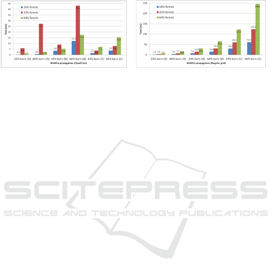
(a) (b)
Figure 7: Execution time results of wildfire propagation computations for terrains (A), (B) and (C).
this refinement implies a better detail of the burn-
ing/fire consequences simulated. Despite these facts,
the computing times were much higher when the
terrains were represented with the regular grid struc-
ture in all tested scenarios.
Regarding the use of regular grids (Fig. 7), a pat-
tern of increasing computing times was related to the
increase of the burned area from 33% to 66%, the
increase of fire-prone areas from 16% to 64%, and
the size of the terrains from (A) to (C). However, a
similar pattern was not observed when the terrains
were represented with the QuadTree. Terrains (A)
and (B) with the QuadTree representation have a
similar computing time pattern related to the in-
crease of fire-prone areas from 16% to 64%. In these
terrains, the time to compute the fire propagation
effects was higher when 32% of the burning area of
the terrains (A) and (B) with the QuadTree were
analyzed. That pattern appeared even when the burn-
ing areas was varied from 33% to 66% in these ter-
rain structures. An exception to it was the terrain
(C), where the computing time increased with the
increase of the fire-prone areas of this terrain from
16% to 64% and the burned areas from 33% to 66%.
In summary, the increase of the percentage of
rivers and the percentage of fire-prone areas in the
tested terrains did not necessarily increase the time
to change the terrain structures due to the flood ad-
vance and wildfire-propagation computations exe-
cuted with the QuadTree. However, the increase of
the computing time for these terrain structure altera-
tions was related to the amplitude of the required
floods and percentage of the burned areas, consider-
ing the tested 2.5m and 5.0m flooding and the 33%
and 66% burning consequences. A similar pattern
was observed when the effects of the flood retreat
were computed in the tested terrain structures. Not
surprisingly, the size of the terrains also had a con-
tribution to the required computing time to change
these terrain structures accordingly.
6 CONCLUDING REMARKS
The use of ABMS is a valuable asset to low-cost,
low-risk training and instruction activities in differ-
ent application fields. In the context of a distributed
simulation architecture in which simulation services
are used to produce dynamic terrain maps for agent-
based simulations, this work proposes the hierar-
chical QuadTree representation for the modelling
and computation with large-scale, real-world ter-
rains. The approach permits to efficiently use the
terrain information captured in the representation
structure, and to make computations with it to ex-
press the terrain changes in the hierarchical terrain
model. This work shows how to do it with the use of
flood fill-based techniques, which are applied to the
analysis and alteration of the QuadTree along with
the exploration of a dictionary-based memory. Based
on two different case studies, ways of working with
the hierarchical structure are discussed, and the
effectiveness of the proposed techniques is demon-
strated. In addition to tests with other terrains, future
works can involve the use of the proposed tech-
niques in the computation of terrain map effects due
to the occurrence of other natural phenomena.
ACKNOWLEDGEMENTS
We thank the Brazilian Army Strategic Program
ASTROS for the financial support through the SIS-
ASTROS GMF project (898347/2020).
REFERENCES
Algfoor, Z. A., M. S. Sunar and H. Kolivand. 2015. A
Comprehensive Study on Pathfinding Techniques for
Robotics and Video Games. International Journal of
SIMULTECH 2022 - 12th International Conference on Simulation and Modeling Methodologies, Technologies and Applications
24

Computer Games Technology: 11.
Brondani, J. R., L. A. de Lima Silva, E. Zacarias and E. P.
de Freitas. 2019. Pathfinding in hierarchical
representation of large realistic virtual terrains for
simulation systems. Expert Systems with Applications
138: 112812.
Byrne, J., C. Heavey and P. J. Byrne. 2010. A review of
Web-based simulation and supporting tools. Simulation
Modelling Practice and Theory 18(3): 253-276.
Cocaud, C. and A. Jnifene. 2010. Environment mapping
using probabilistic quadtree for the guidance and
control of autonomous mobile robots. International
Conference on Autonomous and Intelligent Systems,
AIS 2010, Povoa de Varzim, Portugal, IEEE.
Glassner, A. 1990. Graphics Gems. San Francisco, CA,
Morgan Kaufmann Publishers Inc.
Hawe, G. I., G. Coates, D. T. Wilson and R. S. Crouch.
2012. Agent-based simulation for large-scale
emergency response: A survey of usage and
implementation. ACM Computing Surveys (CSUR)
45(1): 8.
Lees, M., B. Logan and G. K. Theodoropoulos. 2006.
Agents, games and HLA. Simulation Modelling
Practice and Theory 14: 752–767.
Liang, Q., G. Du, J. W. Hall and A. G. Borthwick. 2008.
Flood inundation modeling with an adaptive quadtree
grid shallow water equation solver. Journal of
Hydraulic Engineering 134(11): 1603-1610.
Macal, C. 2016. Everything you need to know about
agent-based modelling and simulation. Journal of
Simulation 10: 144–156.
Nascimento, E. J., E. Zacarias, D. M. Doebber, E. P. de
Freitas and L. A. de Lima Silva. 2019. Flooding-
Driven Modifications of a Hierarchical and Irregular
Navigation Grid Structure for Large Virtual Terrains
used in Simulation Systems. 2019 IEEE 31st
International Conference on Tools with Artificial
Intelligence (ICTAI), IEEE.
Nielsen, J. 1994. Usability engineering, Elsevier.
Pfeiffer, K. D. and T. Tamash. 2014. Measuring the
impact of natural environment representation on
combat simulation outcomes. Interservice/Industry
Training, Simulation, and Education Conference
(I/ITSEC), Orlando, FL.
Rui, X., S. Hui, X. Yu, G. Zhang and B. Wu. 2018. Forest
fire spread simulation algorithm based on cellular
automata. Natural hazards 91(1): 309-319.
Smelik, R., F. van Wermeskerken, R. Krijnen and F.
Kuijper. 2018. Dynamic synthetic environments: a
survey. The Journal of Defense Modeling and
Simulation.
Unity Technologies, I. 2018. "Software Unity®."
Wouter G. van Toll, Atlas F. Cook IV and R. Geraerts.
2012. A navigation mesh for dynamic environments.
Computer Animation and Virtual Worlds 23(6): 535-
546.
Hierarchical Terrain Representation and Flood Fill-based Computation of Large-Scale Terrain Changes for Agent-based Simulations
25
