
Flood Risk Assessment of Heritage Building in Semarang City
Roi Milyardi
a
,
Deni Setiawan
b
and Tri Octaviani Sihombing
c
Department of Civil Engineering, Universitas Kristen Maranatha, Bandung, Indonesia
Keywords: Flood Risk Assessment, Heritage Building, Disaster Risk Management, Hazard, Vulnerability.
Abstract: Semarang City as one of the cities in Indonesia which is a flood-prone area, has historic buildings that are still
functioning. The preservation of heritage building is very important, so it is necessary to carry out a building
risk assessment in order to determine the safety limits of the building. This study aims to carry out a risk
assessment of flood disasters in heritage buildings in the city of Semarang. The methodology used is a risk
assessment carried out with a Risk assessment instrument from the guidelines of the BNPB which is
elaborated with several previous studies conducted on 6 case studies of heritage temple building in Semarang
City. The variables used in this risk assessment are flood hazard, vulnerability (involving of proximity to the
river, building area, building elevation, building materials and conditions), and capacity. The results of the
flood risk assessment showed that 2 temples had a low risk of flooding, and the others were at moderate risk.
The findings in this study, although the 6 case studies are located close to river, the impact of flood risk can
be controlled significantly by the financial sustainable management of cultural heritage buildings as one of
the flood preparedness.
1 INTRODUCTION
The assessment of natural disaster risk in an area or
specifically on buildings has been widely developed
by previous studies. In general, the Crunch model is
the basis for risk assessment in studies that have been
carried out (Hai & Smyth, 2012; Twigg, 2015). The
crunch risk model models disaster risk with
components of vulnerability, hazard and capacity.
Recently development of natural disaster risk models
adds an exposure component and external factors.
The development of a risk model is generally used to
determine the risk component parameters (hazard,
vulnerability, exposure, and capacity) of each
component in accordance with the characteristics of
the conditions in an area.
Assessment of the risk of flooding in cultural
reserve buildings has been carried out in many
previous studies in various countries in the world. The
most significant variation in assessing flood risk in a
cultural heritage is in the component of vulnerability.
Vulnerability components are determined through
architectural style parameters, legal status of cultural
a
https://orcid.org/0000-0003-3025-1356
b
https://orcid.org/0000-0002-0335-2111
c
https://orcid.org/0000-0002-4630-8727
heritage, number of floors, building materials,
maintenance and operating conditions, rainfall until
determined through a flood simulation (Stephenson &
D’Ayala, 2014; Wang, 2014).
Semarang city as the provincial capital in Central
Java which is located in the area of the north coast of
Java has a chronic flood problem. Several previous
studies have shown that community-based disaster
mitigation is quite effective for short-term flood
disaster mitigation in the city of Semarang
(Handayani et al., 2019; Miladan, 2016). Other
research proposes mitigation based on public policies
to reduce urbanization which causes flooding
(Handayani et al., 2020). The age of the city is quite
old (474 years in 2021), making Semarang has quite
a lot of cultural heritage buildings. Due to the flood
problem, various efforts have been made to conserve
cultural heritage buildings from the risk of flooding.
In 2018, UNESCO and the team conducted an initial
strategy study to protect cultural heritage buildings in
Semarang from the danger of flooding with several
short-term strategies, in the form of disaster responses
simulations, early warning systems, etc., as well as
200
Milyardi, R., Setiawan, D. and Sihombing, T.
Flood Risk Assessment of Heritage Building in Semarang City.
DOI: 10.5220/0010748000003113
In Proceedings of the 1st International Conference on Emerging Issues in Technology, Engineering and Science (ICE-TES 2021), pages 200-205
ISBN: 978-989-758-601-9
Copyright
c
2022 by SCITEPRESS – Science and Technology Publications, Lda. All rights reserved
long-term plans that need to collaborate with the
government and many parties (Susanti et al., 2018).
From previous studies, community-based flood
disaster mitigation is one of the effective methods in
Semarang. This study aims to assess the risk of
flooding through the development of a flood risk
assessment instrument in a case study of cultural
heritage buildings, particularly Buddhist temple
heritage buildings in Semarang. It is hoped that from
the results of this study, a community-based flood risk
assessment instrument can be developed, so that flood
disaster resilience in Semarang is strengthened and
cultural heritage buildings can be well conserved.
2 METHODS
The method of assessing flood risk in this study was
developed from several previous studies. Participants
in the development of risk models and data on case
studies conducted in this study.
2.1 Flood Risk Assessment
Risk assessment instruments are based on the crunch
model that has been used in the disaster assessment
instruments issued by the Indonesia’s National
Disaster Management Agency (BNPB). Risk
components consist of Hazard, Vulnerability, and
Capacity.
The flood hazard component is determined based
on the historical height of flood inundation that has
hit the area around the building base on Indonesia’s
National Disaster Management Agency (BNPB)
(BNPB, 2012). The vulnerability component consists
of several sub-components, consists of the distance of
the building to the river (Hazarika et al., 2018), the
area of the affected building, the building structure
material, the age of the building, the height of the
building from the road, the condition of the building
(maintenance), sustainability management (D’Ayala
et al., 2020; Rana & Routray, 2018). Meanwhile, the
capacity component is assessed based on flood
preparedness (BNPB, 2012). The criteria for each
component can be seen in the Table 1.
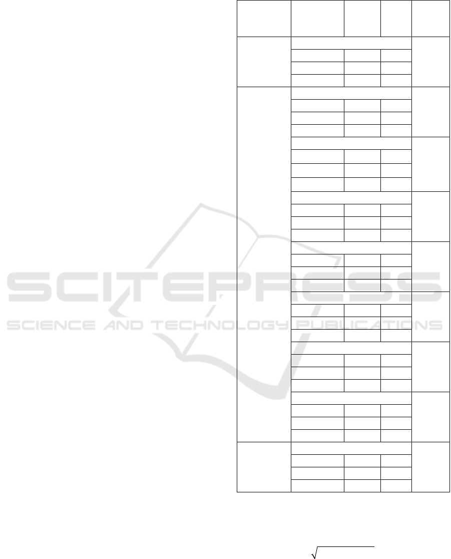
Table 1: Flood risk assessment instruments for cultural
heritage buildings.
Risk
Component
Risk
Parameter
Risk
Value
Risk
Score
Weight
(In Each
Component)
Hazard
Height of flood
100%
<0.76m 1 0.33
0.76-1.5m 2 0.67
>1.5m 3 1
Vulnerability
Distance to the river
14.29%
>3k
m
1 0.33
0.6-3k
m
2 0.67
<0.6k
m
3 1
Building area
14.29%
<200m
2
1 0.33
200-500m
2
2 0.67
>200m
2
3 1
Building frame material
14.29%
Concrete
1 0.33
Masonr
y
2 0.67
Timbe
r
3 1
Age of building
14.29%
<10
y
ears
1 0.33
10-30years
2 0.67
>30
y
ears
3 1
Height of base to road
14.29%
>1
m
1 0.33
-1m to 1
m
2 0.67
<-1
m
3 1
Building condition
14.29%
Goo
d
1 0.33
Poo
r
2 0.67
Very Poo
r
3 1
Sustainability management
14.29%
Goo
d
1 0.33
Poo
r
2 0.67
Ver
y
Poo
r
3 1
Capacity
Preparedness
100%
Very Poo
r
1 0.33
Poo
r
2 0.67
Goo
d
3 1
From the risk score from the results of the field
assessment, the risk calculation is carried out using
the following Formula 1 (BNPB, 2012).
RHV(1C)=××−
(1)
Where R=risk score, H=hazard score, V=
vulnerability score, and C=capacity score.
Flood Risk Assessment of Heritage Building in Semarang City
201

From the risk value, the level category of risk is
determined based on the criteria shown in the Table 2.
Table 2: Risk category parameter.
Risk Score
Risk
Cate
g
or
y
<0.33 Low
0.33-0.67 Moderate
>0,67 High
2.2 Case Study
The risk assessment of cultural heritage buildings was
carried out at 6 temples located in Semarang, namely
Tay Kak Sie Temple, Tek Hay Bio Temple, Siu Hok
Bio Temple, Hwie Wie Kiong Temple, Seh Hoh
Kiong Temple, Sam Po Kong Temple. The locations
of these 6 buildings are scattered on the riverbank in
the city of Semarang, shown in Figure 1 and Figure 2.
1a) Tay Kak Sie Temple. (1b) Tek Hay Bio Temple.
(1c) Siu Hok Bio Temple. (1d) Hwie Wie Kiong Temple
(1e) Seh Hoh Kiong Temple. (1f) Sam Po Kong Temple.
Figure 1: Temple heritage buildings.
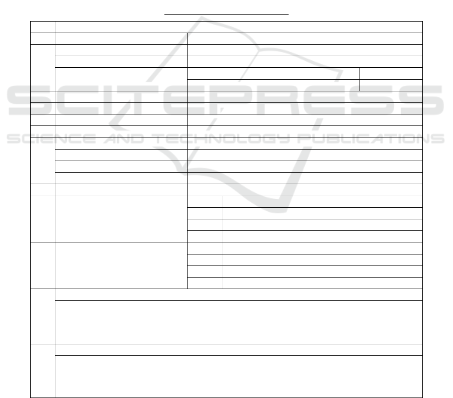
Figure 2: Location of case study in Semarang City.
3 RESULTS AND DISCUSSION
Following are the results of the risk component
survey in the field shown in the Table 3. The results
of the score assessment and risk category are shown
in the Table 4. From the results of the risk assessment
carried out, a risk map can be described as shown in
Figure 3. The resulting risk map is a contribution to
disaster risk management, both in the prevention,
mitigation, preparedness, recovery, and lessons
learned phases (Rimba et al., 2017).
It can be seen from the flood risk map that these
six temples are located in the river area, but the
resulting risk assessment has various values. The
most influencing factor is the capacity for flood
disaster preparedness. From the 6 temples surveyed,
Tek Hay Bio Temple and Sam Po Kong Temple have
flood preparedness, where the aspect that is reviewed
is the aspect of preparedness from the aspects of
operation and maintenance.
In fulfilling the operational and maintenance
aspects, Sam Po Kong Temple is equipped with a
financial model in the form of a tourist attraction as
shown in Figure 4. The existence of a financial model
placing cultural heritage buildings into cultural
heritage gives them more ability to face the risk of
flood impacts. It appears that the building has been
upgraded and maintained. Meanwhile, at the Tek Hay
Bio Temple, preparedness is shown by the presence
of a fairly solid Buddhist community in the temple, so
that preparedness in the financial aspect comes from
the community of the people. In the other 4 temples,
the financial aspect for disaster preparedness is still
relatively limited, considering the limited financial
model unlike the other 2 temples.
ICE-TES 2021 - International Conference on Emerging Issues in Technology, Engineering, and Science
202
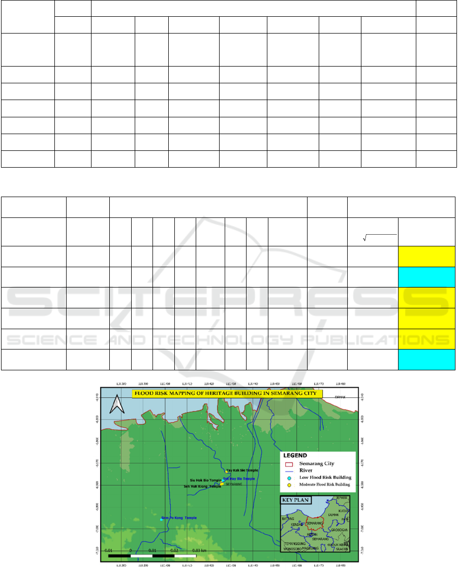
Table 3: Case Studies Data.
Risk
Component
Hazard Vulnerability Capacity
H V
1
V
2
V
3
V
4
V
5
V
6
V
7
C
Heritage
Temple
Building
Height
of Flood
(m)
Distance to
the river
(m)
Buildin
g Area
(m
2
)
Building
Frame
Material
Age of
Building
(year)
Height of
Base from
road
(
m
)
Building
Condition
Sustainability
Management
Preventio
n Action
Tay Kak Sie
Tem
p
le
0.10 46.94 1850 Timber 260 0.5 Good Good Good
Tek Hay Bio
Temple
1.00 45.78 649 Concrete 264 1 Good Good Excellent
Siu Hok Bio
Tem
p
le
0.20 27.00 252 Masonry 267 0 Good Poor Poor
Hwie Wie
K
ion
g
Tem
p
le
0.00 58.53 1794 Timber 220 0.5 Good Poor Good
Seh Hoh
Kion
g
Tem
p
le
0.00 78.65 3453 Timber 139 1 Poor Poor Good
Sam Po Kong
Tem
p
le
1.00 398.00 32200 Concrete 296 3 Excellent Excellent Excellent
Table 4: Results of flood risk assessment in cultural heritage buildings.
Risk
Component
Hazard Vulnerability
Capacity
Risk
Heritage
Temple
Building
H V
1
V
2
V
3
V
4
V
5
V
6
V
7
Weighted
V
C
Risk Value
3
RHV(1C)=××−
Risk
Category
Tay Kak Sie
Temple
0.33 1 1 1 1 0.33 1 1 0.713 0.67 0.427
Moderate
Risk
Tek Hay Bio
Temple
1 1 1 1 1 1 1 1 0.713 1 0
Low Risk
Siu Hok Bio
Temple
1 1 1 1 1 1 1 1 0.714 0.33 0.541
Moderate
Risk
Hwie Wie
Kiong Temple
1 1 1 1 1 0.33 1 1 0.857 0.67 0.454
Moderate
Risk
Seh Hoh Kiong
Temple
0.33 1 1 1 1 1 1 1 0.857 0.67 0.454
Moderate
Risk
Sam Po Kong
Temple
1 1 1 1 1 1 1 1 0.617 1 0
Low Risk
Figure 3: Flood risk map on temple heritage buildings in the Semarang city.
Flood Risk Assessment of Heritage Building in Semarang City
203

Figure 4: Tourism in Sam Po Kong as Financial Model.
The discovery of sustainability issues related to
finance in cultural heritage buildings is relevant to
previous studies, where financial models have also
been developed related to the sustainability of cultural
preservation buildings (Guide, 2021; Jelinčić & Šveb,
2021; Pålsson Skarin, 2011).
In this study, there are several limitations,
including the limited access to historical data
obtained from interviews with temple administrators
which were validated with several secondary sources.
Primary data sources as historical evidence of
inundation height, the exact age of the building
cannot be found with certainty.
However, from the instruments and results of field
surveys conducted, the instruments developed by
elaborating on several previously developed
instruments can provide findings related to the
importance of financial sustainability in flood disaster
mitigation efforts in cultural heritage buildings.
4 CONCLUSIONS
The findings in this study indicate that the risk of
flooding can be reduced by increasing the capacity in
the aspect of financial sustainability.
The assessment instrument developed by
elaborating several instruments in this study can
provide a finding in a case study of cultural heritage
buildings in the city of Semarang.
With the risk mapping carried out in this study, it
can help stakeholders involved in the conservation of
cultural heritage buildings in formulating strategies
and determining policies related to flood disaster
resilience in cultural heritage.
ACKNOWLEDGEMENTS
Data for this paper were based on the “Reconstruction
Project: Study of Heritage Temple in North Coast of
Java for Vihara Satya Budhi Reconstruction” funded
by Vihara Satya Budhi Temple Foundation, Bandung,
West Java, Indonesia. The project was led by
Dr.Sugiri Kustedja and Dr.Cindrawaty Lesmana.
The author is grateful for the anonymous
reviewer’s helpful comments and suggestions as well
as the research team’s feedback.
REFERENCES
BNPB. (2012). Peraturan Badan Nasional
Penanggulangan Bencana No 02 Tahun 2012 Tentang
Pedoman Umum Pengkajian Risiko Bencana. 67.
D’Ayala, Di., Wang, K., Yan, Y., Smith, H., Massam, A.,
Filipova, V., & Jacqueline Pereira, J. (2020). Flood
vulnerability and risk assessment of urban traditional
buildings in a heritage district of Kuala Lumpur,
Malaysia. Natural Hazards and Earth System Sciences,
20(8), 2221–2241. https://doi.org/10.5194/nhess-20-
2221-2020
Guide, P. (2021). Cultural Heritage and Displacement.
Language Issues in Comparative Education II, 163–
188. https://doi.org/10.1163/9789004449671_008
Hai, V. M., & Smyth, I. (2012). The Disaster Crunch
Model : Guidelines for a Gendered Approach. 1–16.
Handayani, W., Chigbu, U. E., Rudiarto, I., & Surya Putri,
I. H. (2020). Urbanization and increasing flood risk in
the Northern Coast of Central Java-Indonesia: An
assessment towards better land use policy and flood
management. Land, 9(10).
https://doi.org/10.3390/LAND9100343
Handayani, W., Hapsari, S. P. I., Mega, A., & Sih, S. J.
(2019). Community-based disaster management:
Assessing local preparedness groups (LPGs) to build a
resilient community in Semarang City, Indonesia.
Disaster Advances, 12(5), 23–36.
Hazarika, N., Barman, D., Das, A. K., Sarma, A. K., &
Borah, S. B. (2018). Assessing and mapping flood
hazard, vulnerability and risk in the Upper Brahmaputra
River valley using stakeholders’ knowledge and
multicriteria evaluation (MCE). Journal of Flood Risk
Management, 11, S700–S716.
https://doi.org/10.1111/jfr3.12237
Jelinčić, D. A., & Šveb, M. (2021). Financial Sustainability
of Cultural Heritage: A Review of Crowdfunding in
Europe. Journal of Risk and Financial Management,
14(3), 101. https://doi.org/10.3390/jrfm14030101
Miladan, N. (2016). Communities’ Contributions to Urban
Resilience Process: a Case Study of Semarang City
(Indonesia) Toward Coastal Hydrological Risk.
Architecture, Space Management. Université Paris-Est.
http://www.theses.fr/2016PESC1010.pdf
ICE-TES 2021 - International Conference on Emerging Issues in Technology, Engineering, and Science
204
Pålsson Skarin, I. (2011). A Finance Model for the Built
Cultural Heritage – Proposals for improvements of
future heritage economics. http://portal.research.
lu.se/portal/en/publications/a-finance-model-for-the-
built-cultural-heritage--proposals-for-improvements-
of-future-heritage-economics(76c3efea-618d-4afc-
9b68-17e8c2943150).html
Rana, I. A., & Routray, J. K. (2018). Integrated
methodology for flood risk assessment and application
in urban communities of Pakistan. Natural Hazards,
91(1), 239–266. https://doi.org/10.1007/s11069-017-
3124-8
Rimba, A., Setiawati, M., Sambah, A., & Miura, F. (2017).
Physical Flood Vulnerability Mapping Applying
Geospatial Techniques in Okazaki City, Aichi
Prefecture, Japan. Urban Science, 1(1), 7.
https://doi.org/10.3390/urbansci1010007
Stephenson, V., & D’Ayala, D. (2014). A new approach to
flood vulnerability assessment for historic buildings in
England. Natural Hazards and Earth System Sciences,
14(5), 1035–1048. https://doi.org/10.5194/nhess-14-
1035-2014
Susanti, B. T., Dewi, D. Y. T. N., & Sunarimahingsih, I. Y.
T. (2018). Developing a Disaster Risk Reduction
Strategy for Semarang Old Town. 56.
Twigg, J. (2015). Disaster Risk Reduction. In Overseas
Development Institute. Overseas Development Institute.
https://doi.org/10.4337/9781782548232.00014
Wang, J. (2014). Flood risk maps to cultural heritage :
Measures and process. Journal of Cultural Heritage.
https://doi.org/10.1016/j.culher.2014.03.002
APPENDIX
Risk Assessment Survey Form
No. Heritage Building Risk Assessment
1 Buildin
g
2
Location
City:
Coordinate:
Latitude
Lon
g
itude
3 Building Function:
4 Area of Building (m
2
):
5 Hei
g
ht of Buildin
g
:
6 Building Structure Material:
7
Building Visitor:
Slack conditions:
Moderate conditions
Crowded conditions:
8 Years Buildin
g
was founded:
9 History of renovation
Year Renovation Detail
10
Disaster History (Fire,
earthquake, flood, volcano,
tornado):
Year Disaster detail and impact
11
Notes
12
Plan Sketch
Flood Risk Assessment of Heritage Building in Semarang City
205
