
Deep Learning based Object Detection and Tracking for Maritime
Situational Awareness
Rihab Lahouli
a
, Geert De Cubber
b
Beno
ˆ
ıt Pairet
c
, Charles Hamesse
d
,
Timoth
´
ee Fr
´
eville and Rob Haelterman
e
Royal Military Academy, Mathematics Departement, Renaissancelaan 30, 1000 Brussels, Belgium
Keywords:
Object Detection, Tracking, Situational Awareness, Maritime Dataset.
Abstract:
Improving real-time situational awareness using deep-learning based video processing is of great interest in
maritime and inland waterway environments. For instance, automating visual analysis for the classification
and interpretation of the objects surrounding a vessel remains a critical challenge towards more autonomous
navigational system. The complexity dramatically increases when we address waterway environments with
a more dense traffic compared to open sea, and presenting navigation marks that need to be detected and
correctly understood to take correct decisions. In this paper, we will therefore propose a new training dataset
tailored to the navigation and mooring in waterway environments. The dataset contains 827 representative
images gathered in various Belgian waterways. The images are captured on board a navigating barge and
from a camera mounted on a drone. The dataset covers a range of realistic conditions of traffic and weather
conditions. We investigate in the current study the training of the YOLOv5 model for the detection of seven
different classes corresponding to vessels, obstacles and different navigation marks. The detector is combined
with a pretrained Deep Sort Tracker. The YOLOv5 training results proved to reach an overall mean average
precision of 0.891 for an intersection over union of 0.5.
1 INTRODUCTION
Deep learning algorithms and precisely CNNs (Con-
volutional neural networks) have shown to be a pow-
erful tool for visual analysis and understanding tasks
such as classification, object detection, and track-
ing (A. Khan and Qureshi, 2020)(G. Ciaparrone and
Troiano, 2020). The great progress in these models
promises to computationally generate an advanced in-
telligence for the detection of collision threats and
recognition of navigation marks without significant
need for human intervention (Z. Chen and Cheng,
2020)(B. Iancu and Lilius, 2021).
In this paper, we report our work in the scope of
the SSAVE project (Shared Situational Awareness be-
tween Vessels), funded by the Flemish Agency for
Innovation and Entrepreneurship. The goal of the
project is to build a shared dynamic semantic map for
a
https://orcid.org/0000-0002-0883-8225
b
https://orcid.org/0000-0001-7772-0258
c
https://orcid.org/0000-0002-8731-033X
d
https://orcid.org/0000-0002-2321-0620
e
https://orcid.org/0000-0002-1610-2218
surveillance purposes. Several sensors are used in the
project and we are in charge of the visual camera pro-
cessing and useful information extraction to consoli-
date the real-time situational awareness system.
Our work consists of implementing a CNN-based
solution able to generate safety alerts in order to avoid
collisions; it can also support decision making in a
maritime environment. The proposed solution intends
to enhance monitoring and safety in waterway envi-
ronments. In recent years, interesting open-source
maritime datasets have been realized and used for
the training of CNN models which has provided an
important contribution in the field of image segmen-
tation in addition to ships and obstacle detection in
the maritime environment. We can cite the Singa-
pore Maritime dataset (DK. Prasad and Rajabally,
2017) that was created around Singapore waters, the
MaSTr1325 dataset with 1325 diverse images and the
MODD2 dataset captured both in the gulf of Koper
“Slovenia” (B. Bovcon and Kristan, 2019)(Borja and
Kristan, 2020).
These datasets are mostly realized in an un-
crowded open-sea which make using them for our ap-
plication irrelevant. In fact, in our project we address
Lahouli, R., De Cubber, G., Pairet, B., Hamesse, C., Fréville, T. and Haelterman, R.
Deep Learning based Object Detection and Tracking for Maritime Situational Awareness.
DOI: 10.5220/0010901000003124
In Proceedings of the 17th International Joint Conference on Computer Vision, Imaging and Computer Graphics Theory and Applications (VISIGRAPP 2022) - Volume 4: VISAPP, pages
643-650
ISBN: 978-989-758-555-5; ISSN: 2184-4321
Copyright
c
2022 by SCITEPRESS – Science and Technology Publications, Lda. All rights reserved
643

waterways navigation zones with high risk of colli-
sion and with the presence of several maritime marks
required for mooring assistance and priorities indica-
tion. To address this issue, we conducted measure-
ment campaigns to collect our custom SSAVE dataset
tailored to the training of the relevant classes that we
need to detect and keep track of, aboard a vessel. Our
main contribution is a new diverse training dataset
addressed for waterways maritime environment cap-
tured by cameras mounted in a drone and a moving
barge in realistic weather and traffic conditions. We
investigate also the training of the YOLOv5 model for
the detection of seven different classes (ship, barge,
cutter, yelow mark, red mark, line mark and other ob-
stacle) for situational awareness purposes. This paper
is organized as follows: Sect.2 describes the collected
SSAVE dataset and the classes that we considered for
the semantic annotation; in Sect.3 distortion correc-
tion of a part of the dataset is presented. In Sect.4,
the results of YOLOv5 detector training are presented
and evaluated. And finally Sect.5 presents inference
results of combining the detection with a Deep Sort
pre-trained tracker; also it gives conclusions and dis-
cusses possible further research perspectives.
2 MARITIME WATERWAY
DATASET: SSAVE
Maritime image datasets are essential for the training
of neural networks performing object detection and
tracking. They should present an important variety
of weather and lighting conditions; also, the images
should be taken with different angles of view.
2.1 SSAVE Dataset
The SSAVE dataset was realized in collaboration
with our industrial partners (Deme and Tresco) in the
project and with the Belgian naval base at Zeebrugge.
We collected thousands of images with high defini-
tion (1080x1920 pixels) in realistic conditions of traf-
fic and in different weather conditions such as sunny,
cloudy and rainy days. We used AXIS Q3515-LV
Network IP cameras mounted on a navigating barge in
addition to GoPro Hero8 cameras placed on a drone
and also attached to a navigating barge. Recording
images from a drone was essential to detect the nav-
igating barge itself and also to have a better view of
the line marks. We hand-picked 827 representative
images out of the gathered footage to construct our
dataset. The variety in terms of luminosity and dis-
tances separating the barges to the obstacles in addi-
tion to the presence of objects of interest with close
proportions have been considered in the selection of
the images constructing the dataset. The dataset is
composed of 78 images taken from a GoPro Hero 8
camera mounted on a drone, 175 images taken from
a similar camera mounted on a navigating barge and
574 images taken from an AXIS Q3515-LV Network
IP camera attached to a navigating barge. Indeed, the
dataset is tailored to the scenarios addressed by the
study corresponding to the navigation of a barge in
a waterway and mooring into a fixed platform called
a cutter. We annotated manually each image in the
dataset using CVAT image annotator. Seven classes
were considered in the annotation (ship, barge, cutter,
yellow mark, red mark, line mark and other obstacle).
Figure 1 presents an example of annotated images.
For instance, we need to detect and track all ships sur-
rounding the navigating barge in addition to all types
of obstacles that can present collision threats. Naviga-
tion marks need to be detected and classified in order
to respect priorities and interdiction areas while navi-
gating and mooring, also the navigation marks can be
subject to collisions. Finally the cutter should be de-
tected and kept in track in order to assist the barge in
mooring properly. We did not proceed to augmenta-
tion techniques to increase the dataset size.
2.2 Preprocessing of Distorted Images
Some of the collected images (about 100) presented
radial distortion. To remedy to this error, we first cal-
ibrated the camera to identify its parameters using the
Matlab camera calibrating tool and a checkerboard
pattern. Then, we used the UndistortImage function
of Matlab to rectify the lens distortion and therefore
convert distorted images into undistorted ones. Fig-
ure 2 presents an example of an image before and af-
ter distortion correction.
3 OBJECT DETECTION AND
TRACKING METHODS
This section presents a brief description of the deep
learning models used for the detection and tracking
tasks. Also, the evaluation metrics used for perfor-
mance measurement are defined.
3.1 YOLOv5 Detection
Object detection is one of the fundamental computer
vision problems that enables semantic video analy-
sis and image understanding. Its concept consists in
identifying precisely in an image the presence and the
VISAPP 2022 - 17th International Conference on Computer Vision Theory and Applications
644
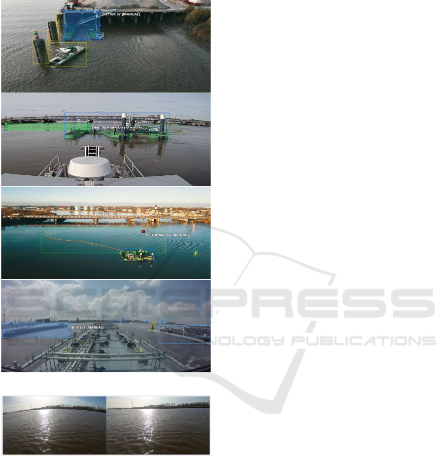
Figure 1: Examples of annotated images.
Figure 2: Image with radial distortion at left and after cor-
rection at right.
location of objects defined in a pre-established list
(PF. Felzenszwalb and Ramanan, 2009).
The “You only look once (YOLO)” detector has
been proposed by (J. Redmon and Farhadi, 2016) as
a novel approach for object detection that makes use
of a unified framework to predict both classes con-
fidence and bounding box coordinates at the same
time. The basic idea of YOLO is to divide the input
image into a grid and compute the bounding boxes
and the probabilities for each cell grid. The predicted
confidence scores are used to weigh these bounding
boxes. The algorithm performs only one forward
propagation pass through the neural network to make
predictions, so it “only looks once” at the input im-
age. YOLOv5 is a recent update of the YOLO ob-
ject detection family. It has been released in 2020
and it was developed with the Pytorch framework.
The YOLOv5 detector is very fast, permitting to per-
form real-time object detection with high accuracy
(Jocher, 2021). The YOLO object detection algo-
rithms have been used for vehicle detection tasks
(Fachrie, 2020) (M. Kasper-Eulaers and Sebulonsen,
2021) and they have proven to outperform other state-
of-the-art CNN algorithms for object detection, such
as Faster R-CNN, in sensitivity and processing time
with a comparable precision (B. Benjdira and Ammar,
2019). These attributes led us to the selection of the
YOLOv5 object detection algorithm for the training
of the SSAVE dataset to detect the classes of interest
in the waterway navigation environment. Decreasing
the processing time gains a significant importance for
real-time detection and traffic monitoring.
3.2 Deep Sort Tracker
Tracking objects in a video at real-time speeds is
a powerful tool for monitoring applications. Deep
Sort is a CNN architecture developed using the Py-
torch framework. It tracks objects along video frames
given their bounding boxes predicted first by a detec-
tor. It was used for pedestrian tracking (N. Wojke and
Paulus, 2017). In our study, the detection generated
by YOLOv5 are passed to the Deep Sort algorithm to
keep track of the detected classes in the video frames.
3.3 Performance Evaluation
The performance evaluation for an object detector
is typically assessed by three metrics that we ex-
plain briefly in this sub-section (I. Goodfellow and
Courville, 2016).
• Intersection over union (IoU): which measures the
overlap degree between the predicted bounding
boxes and the ground truth ones. It is a ratio be-
tween the area of overlap between the two bound-
ing boxes divided by the area of union between
both of them. For a specific IoU threshold we can
measure the accuracy of the predictions by com-
puting the precision recall metrics.
• Precision-Recall: which measures the trade-off
between the precision, being the percentage that
your predictions are correct and the recall which
measures how well you find all the positive cases
over your predictions as presented by the follow-
Deep Learning based Object Detection and Tracking for Maritime Situational Awareness
645
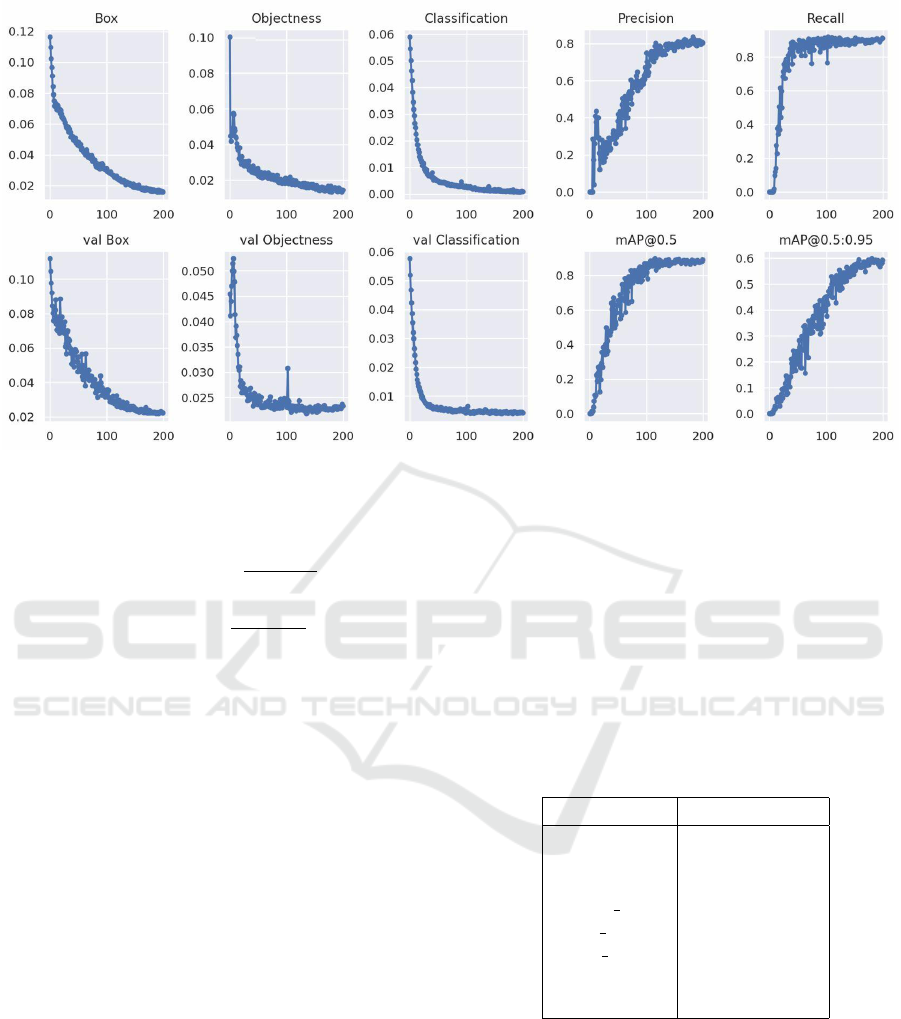
Figure 3: Plots of box loss, objectness loss, classification loss, precision, recall and mean average precision (mAP) over 200
training epochs for the training and validation set.
ing formulas.
Precision =
T P
T P + FP
(1)
Recall =
T P
T P + FN
(2)
Note that, T P is the True Positive, FP is the
False Positive and FN is the False Negative all
measured over the whole prediction of the CNN
model. The relationship between precision and
recall can be observed using a plot.
• Mean Average Precision (mAP): Given a fixed
IOU threshold, the mean precision of each pre-
dicted class is calculated then averaged with all
the classes precision to return the Mean Average
Precision for the dataset.
4 YOLOV5 OBJECT DETECTION
TRAINING USING THE SSAVE
DATASET
In this section, we investigate the performance of the
YOLOv5 detector using the SSAVE dataset.
4.1 Implementation details
All the implementations are performed under the deep
learning framework Pytorch Ultralytics YOLOv5. We
use the docker implementation on an NVIDIA DGX
Station A100 with four fully interconnected NVIDIA
A100 Tensor Core GPUs and up to 128 GB of total
GPU memory. We use the YOLOv5 model pretrained
on the Common Objects in Context (COCO) dataset
(TY. Lin and Hays, 2017) to initialize the network
and extract features from the input images. Then we
prepare our custom SSAVE dataset with 827 images
by splitting it into training, validation and test data
with percentage of 70%, 20% and 10% respectively.
The computational cost of training the model for 200
epochs takes about 89 minutes.
Table 1: Detection precision per class.
Classes Precision
ship 0.877
barge 0.995
cutter 0.940
yellow mark 0.986
red mark 0.887
line mark 0.842
other obstacle 0.713
all classes 0.891mAP@0.5
4.2 Experimental Analysis
Figure 3 shows the evolution of different performance
metrics over the 200 training epochs for both the
training and validation sets. There are three losses
that the model should minimize to achieve a detec-
tion, location and classification convergence. The box
loss represents how well the predicted bounding box
covers an object. Objectness loss refers to the prob-
VISAPP 2022 - 17th International Conference on Computer Vision Theory and Applications
646
ability that an object exists in a proposed region of
interest. The classification loss represents how well
the algorithm can predict the correct class of a given
object. We notify a rapid decline of the box, object-
ness and classification losses until around 150 epochs.
The model also showed a rapid improvement in terms
of precision, recall and mean average precision. It
achieved a 0.891 mAP at 0.5 IOU as shown by Fig-
ure 4. We also see a high precision between 0.842
and 0.995 for all the classes except the “other obsta-
cle” class where the precision reaches only 0.713 as
resumed in Table 1 . This is explained by the fact that
this class includes objects with different forms going
from poles to small obstacles that can not be included
in the other categories but they need to be detected in
order to notify the navigating vessel about a collision
threat. Figure 9 presents the qualitative performance
of prediction of the new trained YOLOv5 model ap-
plied to a test batch for detecting the seven classes
(ship, barge, cutter, yellow mark, red mark, line mark
and other obstacle).
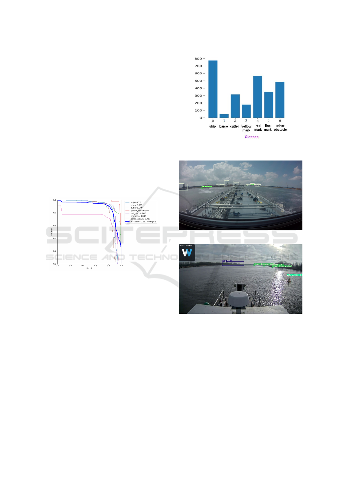
Figure 4: Precision recall curve.
4.3 Discussion
Figure 5 shows the proportion distribution of the
seven annotated classes into the training dataset.
“Ship” category is the most presented with more than
770 bounding boxes. On the other hand, the barge cat-
egory is the least represented. This is due to the fact
that most images have been captured using the camera
attached to the barge. Thus the barge was present only
in images captured by the drone. therefore the classes
are unbalanced in the dataset and this problem can
be considered in future work to further enhance the
detection of under-represented classes. The low pre-
cision of the “other obstacle” class led to some false
negative detection as shown by Figure 6 where some
obstacles present in the image were not detected al-
though detection with a confidence score of 0.55 has
been done for a neighbour obstacle. Also the vege-
tation background in the waterways led to some false
positive detection as presented by Figure 7 where the
Figure 5: Proportion of each annotated class in the training
dataset.
Figure 6: False negative detection for “other obstacle” class.
Figure 7: False positive detection for “ship” class.
detector has assumed by mistake a ship in the vege-
tation. In the other hand, Figure 8 presents example
results of correct detection for all the objects present
in the images. Data augmentation techniques are also
commonly used to increase the data size and variance
by generating geometric perturbations, Gaussian blur
and noise (B. Zoph and Ghiasi, 2020). We suggest to
investigate the capability of augmentation strategy to
enhance the detection performances.
Deep Learning based Object Detection and Tracking for Maritime Situational Awareness
647

Figure 8: Correct detection results.
5 CONCLUSIONS
In this paper, we introduced a new dataset tailored to
the training of object detection CNN models for situ-
ational awareness purposes in the maritime waterway
environments. Up to 827 representative images with
high variety have been selected manually from video
recording in real scenarios of navigation and mooring.
Ip cameras attached to a navigating barge in addition
to a camera attached to a drone have been used to en-
sure a variety in the angles of view of the objects to
detect. Seven different classes have been annotated
manually which are; ship, barge, cutter, yellow mark,
red mark, line mark and other obstacle. The main con-
cern was about the implementation of a CNN-based
object detection algorithm able to alert the vessels
about the presence of collision threats in the neigh-
borhood in addition to the detection and the correct
interpretation of the navigation marks present in the
waterway in order to help the vessel taking the right
decisions. We chose to train the YOLOv5 object de-
tection model due to its better performances in terms
of processing time with similar precision compared
to other state-of-the-art object detection models. We
have trained the YOLOv5 using our dataset and we
obtained successful results achieving a mean average
precision of 0.891 at an intersection over union of 0.5.
The precision of predictions by classes was also high
reaching 0.995 and not less than 0.713. Qualitative
results corresponding to prediction results on test im-
ages have been presented. The detection generated by
YOLOv5 has been passed to the pretrained Deep Sort
algorithm and we tested the results on real videos of a
navigating barge and the results were satisfying. For
future work, we suggested to investigate into increas-
ing the presence of the least representative classes in
the dataset in order to deal with unbalanced classes.
Also we suggested to test some common augmenta-
tion techniques on the SSAVE dataset and analyse if
we can achieve better results.
ACKNOWLEDGEMENTS
The research presented in this paper has been funded
by the Flemish Agency for Innovation and En-
trepreneurship (VLAIO), project SSAVE.
REFERENCES
A. Khan, A. Sohail, U. Z. and Qureshi, A. (2020). A sur-
vey of the recent architectures of deep convolutional
neural networks review. Artificial Intelligence Review,
53:5455–5516.
B. Benjdira, T. Khursheed, A. K. and Ammar, A. (2019).
Car detection using unmanned aerial vehicles: Com-
parison between faster r-cnn and yolov3. In 2019
1st International Conference on Unmanned Vehicle
Systems-Oman (UVS). IEEE.
B. Bovcon, J. Muhovi
´
c, J. P. and Kristan, M. (2019). The
mastr1325 dataset for training deep usv obstacle de-
tection models. In IEEE/RSJ International Confer-
ence on Intelligent Robots and Systems. IEEE.
B. Iancu, V. Soloviev, L. Z. and Lilius, J. (2021). Aboships-
an inshore and offshore maritime vessel detection
dataset with precise annotations. Remote Sensing,
13(5):988.
B. Zoph, E. C. and Ghiasi, G. (2020). Learning data aug-
mentation strategies for object detection. In ECCV.
Borja, B. and Kristan, M. (2020). A water-obstacle sepa-
ration and refinement network for unmanned surface
vehicles. In 2020 IEEE International Conference on
Robotics and Automation (ICRA). Computer Science.
DK. Prasad, D. Rajan, L. R. and Rajabally, E. (2017). Video
processing from electro-optical sensors for object de-
VISAPP 2022 - 17th International Conference on Computer Vision Theory and Applications
648
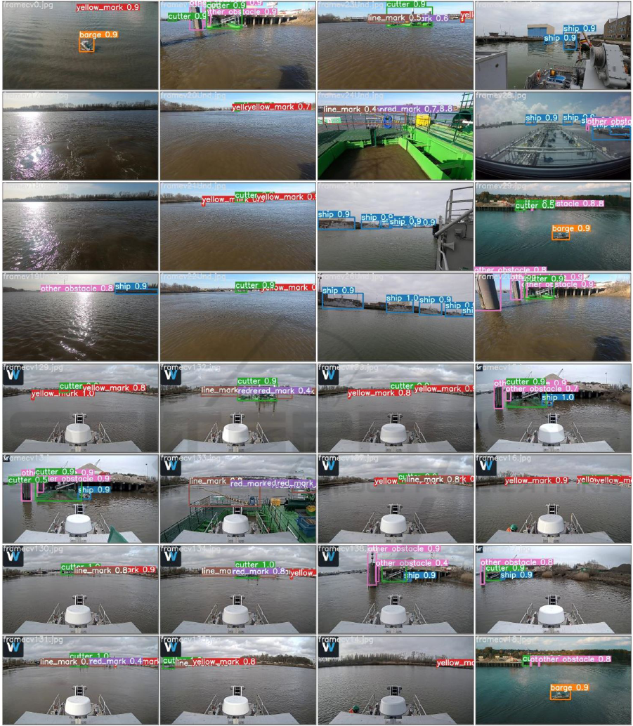
Figure 9: Images from the test dataset showing the performance for predicting the seven classes; ship, barge, cutter, yellow
mark, red mark, line mark and other obstacle.
tection and tracking in a maritime environment: a sur-
vey. IEEE Transactions on Intelligent Transportation
Systems.
Fachrie, M. (2020). A simple vehicle counting system us-
ing deep learning with yolov3 model. Journal RESTI
(Rekayasa Sistem DanTeknologi Informasi), 4:462–
468.
G. Ciaparrone, FL.S
´
anchez, S. T. and Troiano, L. (2020).
Deep learning in video multi-object tracking: A sur-
vey. Neurocomputing, 381:61–88.
I. Goodfellow, Y. B. and Courville, A. (2016). Deep Learn-
ing. MIT Press. http://www.deeplearningbook.org.
J. Redmon, S. Divvala, R. G. and Farhadi, A. (2016). You
only look once: Unified, real-time object detection.
Deep Learning based Object Detection and Tracking for Maritime Situational Awareness
649

Computer Vision and Pattern Recognition.
Jocher, G. (2021). Yolov5 in pytorch.
https://github.com/ultralytics/yolov5.
M. Kasper-Eulaers, N. Hahn, S. B. and Sebulonsen, T.
(2021). Short communication: Detecting heavy
goods vehicles in rest areas in winter conditions us-
ing yolov5. Algorithms, 14:114.
N. Wojke, A. B. and Paulus, D. (2017). Simple online and
realtime tracking with a deep association metric. In
Computer Vision and Pattern Recognition. Computer
Science.
PF. Felzenszwalb, RB. Girshick, D. M. and Ramanan, D.
(2009). Object detection with discriminatively trained
part-based models. IEEE transactions on pattern
analysis and machine intelligence, 32(9):1627–1645.
TY. Lin, M. Maire, S. B. and Hays, J. (2017). Microsoft
coco: Common objects in context. In European con-
ference on computer vision. Springer.
Z. Chen, D. Chen, Y. Z. and Cheng, X. (2020). Deep learn-
ing for autonomous ship-oriented small ship detec-
tion. Safety Science, 130:104812.
APPENDIX
The SSAVE dataset has been made publicly available
at:
https://mecatron.rma.ac.be/index.php/publications/datasets/
VISAPP 2022 - 17th International Conference on Computer Vision Theory and Applications
650
