
Application of Deep Learning Techniques in Negative Road
Anomalies Detection
Jihad Dib
*a
, Konstantinos Sirlantzis
b
and Gareth Howells
c
School of Engineering and Digital Arts, Jennison Building, University of Kent, Canterbury CT2 7NT, U.K.
Keywords: Pothole Detection, Road Anomaly, Deep Learning, Deep Neural Network, Convolutional Network,
Image Processing, Object Detection, Object Classification.
Abstract: Negative Road Anomalies (Potholes, cracks, and other road anomalies) have long posed a risk for drivers
driving on the road. In this paper, we apply deep learning techniques to implement a YOLO-based (You Only
Look Once) network in order to detect and identify potholes in real-time providing a fast and accurate
detection and sufficient time for proper safe navigation and avoidance of potholes. This system can be used
in conjunction with any existing system and can be mounted to moving platforms such as autonomous vehicles.
Our results show that the system is able to reach real-time processing (29.34 frames per second) with a high
level of accuracy (mAP of 82.05%) and detection accuracy of 89.75% when mounted onto an Electric-
Powered Wheelchair (EPW).
1 INTRODUCTION
Negative Road Anomalies is the term we have chosen
to describe potholes, cracks, and any anomaly located
at a negative position of the road surface.
Potholes pose the highest risk in all negative road
anomalies as they are a danger to drivers when
driving on roads, and im some cases motorways.
They could cause severe injury to the driver in form
of neck pain, back pain, whiplash and more severe
health risks. Not to mention, the damage which could
be caused to the car’s mechanical system and tires
putting the driver under numerous risks of accidents
and even threatening their life as a result of a torn tire
or other mechanical damage which could be caused
to the vehicle driven when passing over a pothole at
high speed. Potholes were also a significant limitation
to the driverless car advancement projects due to the
stochasticity of their nature and the difference in their
depth and severity making them hard to identify and
detect, and rendering many detection techniques
futile as they sometimes contain some characteristics
which could fall within the limitations of the
detection techniques (for example, water-filled
a
https://orcid.org/0000-0002-3070-9673
b
https://orcid.org/0000-0002-0847-8880
c
https://orcid.org/0000-0001-5590-0880
potholes cannot be detected via ultrasonic sensing
techniques).
In our ongoing project, we apply deep learning
techniques in order to detect and identify potholes.
Our project is mainly focused on object detection
neural networks which can be used in real-time in
order to detect and classify potholes from the video
stream obtained through the use of an RGB Camera,
and to provide a fast and reliable detection method
which allows sufficient time and distance for a safe
avoidance and navigation of manual and autonomous
vehicles and moving platforms.
YOLO (Redmon et al.,2015) (You Only Look
Once) is the candidate network which is used in this
project due to its high accuracy and fast performance,
especially in real-time detection scenarios. The
project was implemented over the Darknet (Redmon
et al.,2020) environment which was developed by the
authors and creators of YOLO and was optimized and
tested in real-time scenarios where it returned
significant promising results.
Many attempts to detect potholes were made, and
different technology was used in order to implement
solutions to the proposed problem. Some solutions
were implemented via the use of laser imaging as
Dib, J., Sirlantzis, K. and Howells, G.
Application of Deep Learning Techniques in Negative Road Anomalies Detection.
DOI: 10.5220/0011336000003332
In Proceedings of the 14th Inter national Joint Conference on Computational Intelligence (IJCCI 2022), pages 475-482
ISBN: 978-989-758-611-8; ISSN: 2184-3236
Copyright © 2023 by SCITEPRESS – Science and Technology Publications, Lda. Under CC license (CC BY-NC-ND 4.0)
475

Figure 1: Pothole Detection System Diagram.
input (Yu and Salari,2011), (Vupparaboina et.
al,2015) where different regions of the laser colours
were extracted with the help of image processing,
thermal imaging was also used by fusing thermal
imaging and convolutional neural networks (Aparna
et al.,2019) while others used visible light RGB
cameras with supervised learning techniques by
analysing the road’s surface feature in order to
classify potholes via HOG feature extraction (Azhar
et al.,2016), while (Koch and Brilakis,2011) used
segmentation in order to split mages into two
categories (defective and non-defective) via the use
of the histogram approach with shape-based
thresholds [ (Ryu et. al,2015), (Schiopu et. al,2016),
and (Saluja et. al,2019) on the other hand used video
sequences taken by RGB cameras via their own
thresholding algorithm which considers potholes as
the images with high-intensity values. Other
techniques such as Probabilistic Generative Models
(PGM) fused with Support Vector Machine (SVM)
techniques were used in order to detect the probability
of occurrence of a road crack via the intensity details
was used by (Ai et. al,2018) while (Youquan et.
al,2011), (Zhang et. al,2016) and (Li et. al,2018)
have relied on stereo-vision techniques in different
setups in order to detect potholes via their shapes, or
by estimating the difference between the surface of
the road and the surface of the pothole. (Moazzam et.
al,2013) used a depth camera via the detection of the
area, depth, length, width and volume of the pothole,
while (Avellaneda and López-Parra,2016), (Buttlar
and Islam,2014), and (Forslöf and Jones,2015) have
used the accelerometer, compass and GPS found in
mobile phones in order to achieve post-pothole
detection, when (Chellaswamy et. al,2018) have used
ultrasonic sensors. A more detailed review can be
found in our previous publication A Review on
Negative Road Anomalies (Dib et. al,2020)
The previously mentioned techniques were all
limited due to the fact that post-detection of potholes
cannot be used in order to avoid potholes. Ultrasonic
sensors, laser-imaging techniques, surface difference-
based techniques and depth camera-based techniques
are limited when it comes to water-filled potholes as
water can be reflective, and there will be no or
insignificant surface difference between the surface
of the water and the surface of the pothole.
This paper describes the current progress of the
negative anomaly detection project and proposes the
use of a normal RGB camera where the stream being
fed to a custom-trained YOLO network which will
achieve the real-time detection of the pothole. A
dataset of pothole images was collected, preprocessed
and used to train the neural network in order to fulfil
the task required.
2 PROPOSED APPROACH
We propose the use of deep learning neural networks,
mainly YOLO developed using the Darknet
environment having an input obtained by an RGB
camera mounted on any moving platform. This could
be a self-driven car, driven car, truck, motorcycle, or
even an electric-powered wheelchair or a robot.
A core computing unit will be mounted onto the
moving platform. The RGB Camera’s video feed will
be processed by the computing unit which will be
running the Robot Operating System (ROS) (ROS
Wiki,2020) and will process the video feed and feed
it into the pothole detection system (Figure 1).
First, the captured video feed will be pre-
processed by converting the feed into RGB format (if
it is not already in RGB format), then, the frames are
downscaled to 416x416 pixels. Padding is used in the
event where the downscaled frames have either a
height or a width less than 416 pixels. Then, the
frames will be processed by the YOLO convolutional
neural network in order to detect and localise the
potholes based on the features which the network is
trained to detect. Potential pothole candidates will be
detected, and the probability of the candidate being a
true positive detection will be calculated according to
the formulas discussed in Part 3 of this paper. If the
ROBOVIS 2022 - Workshop on Robotics, Computer Vision and Intelligent Systems
476
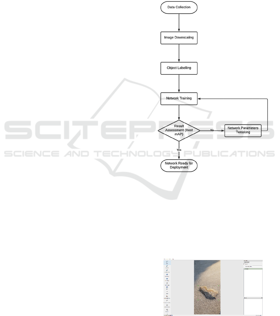
network’s confidence is more than 0.7 (70%) the
detected object is considered a pothole, it will be
considered a positive detection, the x1,y1,x2,y2
coordinates of the bounding box are calculated, and
the bounding box is drawn around it marking its
location within the video frame. At this stage, this
approach ensures reliability, scalability, and high
performance.
Our approach’s main goal is to ensure real-time
detection with the least possible computing and
power requirements. This will enable the use of the
system in real-time scenarios without the need to rely
on equipment with high computational power which
could drain the battery used. This will ensure the
ability to use our system in real-life scenarios and
potentially provide a standard platform for both
negative and positive obstacle detection and
avoidance.
3 EXPERIMENT
For this experiment (Figure 2), different versions of
the YOLO network were trained on a self-collected
dataset which includes photos from different
scenarios which could be encountered within an
everyday usage of any vehicle/moving platform.
The images dataset which has been used to train
the neural network was collected during the research
phase using a Samsung Galaxy Note 8 phone camera
taking images at 13 Megapixels. Images were
collected within Kent County in the United Kingdom
from different roads and cities in different weather
conditions (sunny, cloudy, and rainy days and nights).
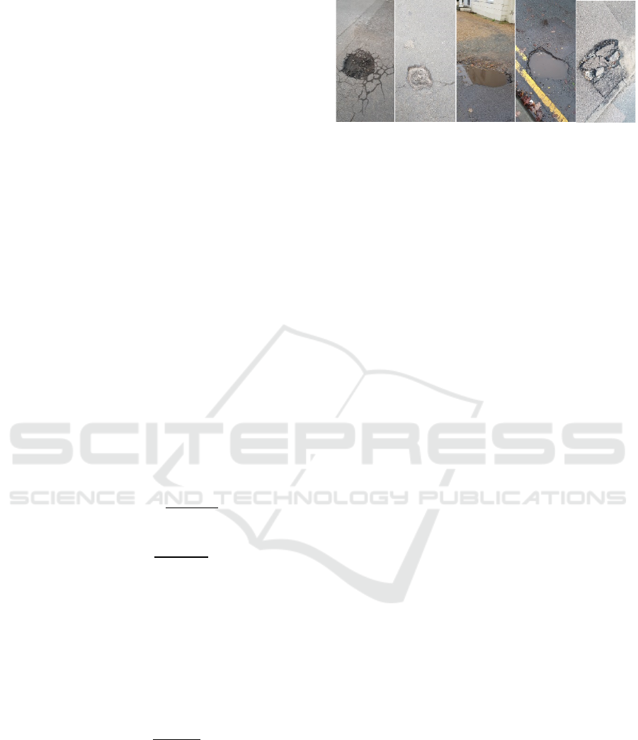
Figure 4 presents a sample from our dataset:
(a) represents a general-looking pothole, i.e. a
hole within the tarmac in an quasi-circular
shape.
(b) represents a shallow circular broken
surface/crack within the tarmac floor which is
usually hard to detect by laser-based systems.
(c) represents a stochastic-shaped pothole, filled
with water and dirt with a completely different
pattern than the tarmac surrounding it. This
cannot be detected by laser-based or sonar-
based systems.
(d) represents a random-shaped pothole filled
with water which is nearly clear and located
on the side of the road where the double lines
are clearly shown making it very difficult to be
detected by normal image-based systems,
laser-based systems, and sonar-based systems.
(e) represents a stochastic-shaped broken side of
the road filled with rabble which is also very
challenging for image-based, laser-based, and
sonar-based systems due to the stochastic
shape, and the reflective randomly-located
rabble.
This dataset will be made available online at a later
stage.
Figure 2: Network Training Process.
The collected images were pre-processed by
downscaling them to 30% in order to obtain a width
of around 415 pixels and then they were labelled
individually using the labelling tool LabelImg
(GitHub,2020) for Python ensuring that all the
surrounding boxes cover the exact corners of the
pothole without adding a lot of background data
which could cause any diversion in the learning
process.
Figure 3: Labeling the dataset images via LabelImg.
Application of Deep Learning Techniques in Negative Road Anomalies Detection
477
The network training phase was done by using
more than one platform and more than one version of
YOLO in order to collect numerous test results and
perform benchmarking.
All training experiments were done using an Intel
Core i7 desktop with an NVIDIA RTX2080 6GB
memory graphical processing unit (GPU) running a
Windows 10 OS with Anaconda (Anaconda,2020) as
a platform to run the Python environment on
Windows.
In order to calculate the accuracy of the detection
denoted by precision, we have considered the
detection a true positive if the maximum overlap
between the detected region (detected box) and the
original annotation (annotated box of the RoI (Region
of interest i.e. pothole) within the validation dataset)
is larger than or equal to the Intersection over Union
(IoU) (Rosebrock,2020) which is the area of overlap
between the detected region and the annotation region
divided by the area of the union which is the union of
both areas combining the detected region and the
annotated region:
After calculation, the precision of every detection,
the mean average precision (mAP) is calculated via
the calculation of the precision envelope, the area
under the curve (points where the recall changes) and
then the summing of those values. This has been
described extensively in (Medium,2020)
The precision and recall formulas are as follows:
𝑃𝑟𝑒𝑐𝑖𝑠𝑖𝑜𝑛 =
𝑇𝑃
𝑇𝑃 + 𝐹𝑃
𝑅𝑒𝑐𝑎𝑙𝑙 =
𝑇𝑃
𝑇𝑃 + 𝐹𝑁
where TP is the number of true positives, FP is the
number of false-positive, and FN is the number of
false negatives.
The mean average precision (mAP) is the mean of
the average precisions calculated, i.e. the sum of all
average precisions divided by the number of
detections.
𝑚𝐴𝑃 =
∑
𝐴𝑃
𝑁
where N is the number of detections, and AP is the
Average Precision (described in (Anaconda,2020))
In addition to the previous values, we have
recorded the frame rates achieved by the algorithm
(a) (b) (c) (d) (e)
Figure 4: Samples images taken from our manually-
collected dataset.
when tested in order to assess whether the detection
is in real-time or not.
In our training experiments, we have set the IoU
to 70 so detection is considered a true positive when
there is an overlap that is more than 70% (YOLO uses
a default IoU threshold of 0.3 (30%) which we have
raised to 0.7).
We have attempted more than one training
experiment and split them into three main sets. In
every set, we have tried several different number of
training and validation datasets as follows:
• 80% of the total number of images in the
dataset is used as training data, the rest is used
as validation images.
• 70% of the total number of images in the
dataset is used as training data, the rest is used
as validation images.
• 60% of the total number of images in the
dataset is used as training data, the rest is used
as validation images.
We have also attempted more than one different
learning rate, as follows:
• Learning Rate = 1e-4
• Learning Rate = 1e-5
• Learning Rate = 9e-5
The first training set of experiments was made
using YOLOv2 (Redmon et al., 2015) trained using
Keras (Team K.,2020) (Keras Website) open-source
neural network library with the following training
parameters:
• Training Images: 574 (80% of the dataset)
• Validation Images: 143 (20% of the dataset)
• Learning Rate = 1e-4
• IoU = 0.7
The training resulted in a best mAP of 71.5%, 102
true positives, 41 false positives, and upon testing the
neural network performance on a “challenging” input
with more than one pothole present, the following
results were obtained:
ROBOVIS 2022 - Workshop on Robotics, Computer Vision and Intelligent Systems
478
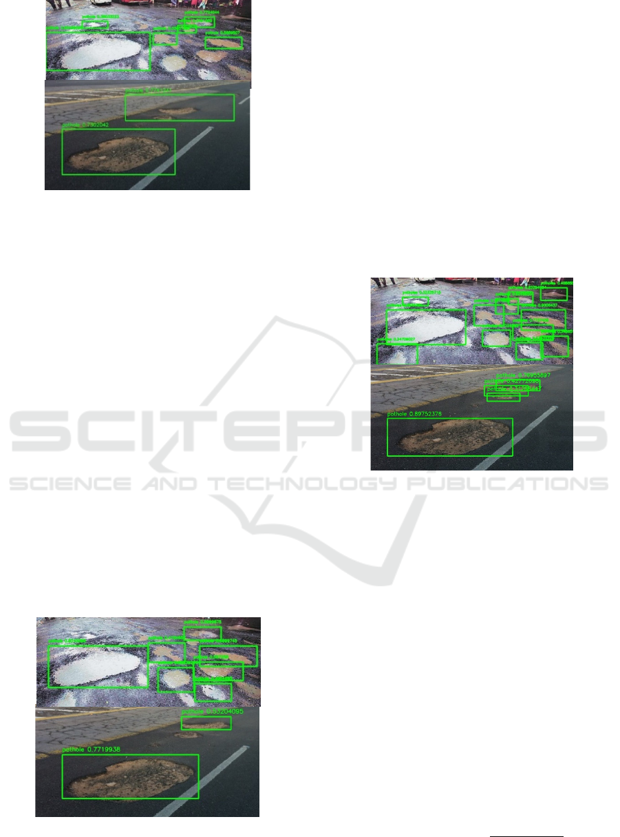
Figure 5: YOLOv2 Test Results.
It is evident from the first test results (Figure 5)
that this network is not really fit for purpose as its
result is a larger region of interest (ROI) detected
versus the optimal ROI which should have been
detected. A larger ROI can be acceptable as it means
that the network has detected the object of interest
which means that avoidance can be achieved,
however, our aim is to obtain the most optimal
detection possible. In addition, the network has
detected only 6 potholes within the first example and
only two in the second example along with a larger
ROI where two potholes were considered as only one.
Not to mention that the detection accuracy is only
0.7302 for the bottom pothole in the second example
which is 73.02% for the most evident pothole. As for
the frame rate achieved, it was 44 frames per second
as reported by the algorithm.
The second training set of experiments was made
using YOLOv3 (Redmon and Farhadi, 2018) trained
using Keras with the same parameters as the previous
training.
The network’s best mAP was 75.48%, the number
of true positives was 108 along with 35 false positives
and the test input returned the following results:
Figure 6: YOLOv3 Test Results.
The results obtained via YOLOv3 look slightly
more promising than YOLOv2 as the network has
detected 7 potholes in the first example and only two
in the second but with tighter ROIs covering the exact
borders of the potholes. In the second example, the
evident pothole’s detection accuracy was 0.7719
which is 77.19% which shows a slight improvement
from the first network used. The frame rate was
almost the same as the previous test (47 frames per
second)
The training set of experiments was made using
YOLOv4 (Bochkovskiy et. al, 2020) trained using
Darknet environment with the same parameters as the
previous training. The network’s best mAP was
82.05%, the number of true positives was 117, and the
false positives were 26. The test input returned the
following results:
Figure 7: YOLOv4 Test Results.
The results obtained via YOLOv4 were the most
promising results as the network has detected 12
potholes within the first example along with three
potholes in the second example as the network has
identified the two small potholes as an additional
partial pothole. The accuracy of the detection for the
evident pothole is 0.8975 which is 89.75% which was
the highest obtained accuracy within the tests
aforementioned. This experiment was achieved with
a frame rate of 49 frames per second which is the
highest frame rate achieved in all of our experiments.
Knowing that the speed limit for vehicles in
residential areas in England is 30 mph (48.28 km/h or
13.411 m/s), and for other moving platforms such as
electric-powered wheelchairs (EPWs) is 4 mph (6
km/h or 1.67 m/s) offroad (on a footpath, on a
pavement, etc.) and 8mph (12 km/h or 3.3333 m/s) on
the road (on tarmac) we can easily calculate our
detection-rate via the formula:
𝐷𝑒𝑡𝑒𝑐𝑡𝑖𝑜𝑛 𝑅𝑎𝑡𝑒 =
𝐹𝑟𝑎𝑚𝑒 𝑅𝑎𝑡𝑒
𝑀𝑎𝑥 𝑆𝑝𝑒𝑒𝑑
Application of Deep Learning Techniques in Negative Road Anomalies Detection
479

Figure 8: Real-time testing of the YOLO Network applied on an online video [29] where three consecutive frames have been
extracted. In the test above, the precision rate of the detection is respectively: pothole 1.a: 85%, pothole 1.b: 73%, and pothole
1.c: 95% pothole 2.a: 56%, pothole 2.b: 82%, and pothole 2.c: 97%. pothole 3.a: 53%, pothole 3.b: 70%, and pothole 3.c:
96%. The Average Frame Rate achieved is 52 fps which is considered real-time.
By applying this formula to vehicles in rural areas,
we can conclude that our detection rate is
49
13.411
=3.65
i.e. 3.65 frames per meter, as for the off-road
wheelchair, it is 29.34 frames per meter and the on-
road wheelchair detection rate is 14.70 frames per
meter. These detection rates achieved are more than
sufficient for safe navigation and avoidance of the
pothole as the lowest detection rate (3.65 achieved
when the system is mounted to cars in rural areas)
allows at least 3 frames to be detected within every
meter and as is known, 49 frames per second are
larger than the commonly-used real-time threshold
for frame-rate which is 30 frames per second. Figure
8 represents the real-time results obtained when using
an mp4 video (ITV News YouTube Channel, 2018)as
input to the network. In order to demonstrate the
result, we have extracted three consecutive frames
from the resulting video showcasing the detection rate
achieved with the real-time frame rate of an average
of 52 frames per second.
In addition to the previous training attempts, a
separate attempt was made with the same training and
validation ratios, along with different learning rates in
order to attempt to find additional methods of
improving the detection and studying the effect of the
learning rate and the training/validation ratio on the
mean average precision of the network’s detection
performance. The results were as follows:
Table 1: YOLO with Learning Rate = 1e-4.
Ratio
Trainin
g
/Validation
0.8 0.7 0.6
mAP 0.765 0.725 0.702
True Positives 109 156 302
False Positives 34 59 128
Table 2: YOLO with Learning Rate = 2e-4.
Ratio
Trainin
g
/Validation
0.8 0.7 0.6
mAP 0.5939 0.474 0.455
True Positives 85 102 196
False Positives 58 113 234
Table 3: YOLO with Learning Rate = 1e-5.
Ratio
Trainin
g
/Validation
0.8 0.7 0.6
mAP 0.521 0.497 0.434
True Positives 75 107 187
False Positives 68 108 243
Table 4: YOLO with Learning Rate = 9e-5.
Ratio
Trainin
g
/Validation
0.8 0.7 0.6
mAP 0.616 0.605 0.603
True Positives 88 130 259
False Positives 55 85 171
a
b
c
1
3
2
ROBOVIS 2022 - Workshop on Robotics, Computer Vision and Intelligent Systems
480

Table 5: YOLO with Learning Rate = 8e-5.
Ratio
Trainin
g
/Validation
0.8 0.7 0.6
mAP 0.681 0.671 0.532
True Positives 97 144 229
False Positives 46 71 201
Table 6: YOLO with Learning Rate = 7e-5.
Ratio
Trainin
g
/Validation
0.8 0.7 0.6
mAP 0.617 0.582 0.532
True Positives 88 125 229
False Positives 55 90 201
Table 7: YOLO with Learning Rate = 6e-5.
Ratio
Trainin
g
/Validation
0.8 0.7 0.6
mAP 0.615 0.647 0.543
True Positives 88 139 233
False Positives 55 76 197
As we can observe from this experiment, the
detection’s mAP is generally larger when the number
of images used for training is larger which can be
observed when comparing the mAP values at the
different training/validation ratios. In addition, we
can observe that setting the learning rate to 1e-4
returned the highest mAP value. However, 8e-5 and
9e-5 did return acceptable results at a
training/validation ratio of 0.8 which leads us to
conclude that a variable learning rate would be more
ideal in respect to the validation loss, this could
improve the results obtained and will be assessed in
future work.
4 CONCLUSIONS
In this paper, we have implemented a deep learning-
based system which detects and localises different
types of potholes regardless of the stochasticity in
their shapes, textures, patterns, and colours in real-
time (i.e. high frame rates achieved within the
experiments undertaken), and with high accuracy.
The results obtained show that the accuracy of
the detection was very high even in the case of water-
filled potholes which is usually considered the main
limitation of many sensing techniques. Not to
mention that the detection rate and the frame rates
achieved were more than sufficient for our detection
rate to be considered real-time providing sufficient
detection speed and distance for a safe navigation and
avoidance of potholes.
We can also conclude that the training results
could be improved by varying the learning rate
throughout the learning process, and by increasing the
size of the training dataset used.
The next steps will focus on further use of deep
learning object detection convolutional neural
networks. In future work, there will focus on
including more functionalities, such as object
localization in real-world 3D coordinates and more
additional functionalities via the use of additional
sensing techniques fused by a data fusion algorithm.
This algorithm will combine the use of more than one
sensing technique in such a way that every technique
used will cover the other techniques’ weaknesses and
limitations via the use of multimodal sensing
techniques combined with deep learning. The
proposed algorithm could be the backbone of a wide
range of systems and it can be used to make decisions
ensuring safe navigation of the moving platform
when needed.
ACKNOWLEDGEMENTS
We would like to acknowledge the help Engineering
and Physical Sciences Research Council (EPSRC)
who funded the project via studentship reference
2112938 and Assistive Devices for empowering dis-
Abled People through robotic Technologies
(ADAPT). ADAPT is selected for funding by the
INTERREG VA France (Channel) England
Programme which is co-financed by the European
Regional Development Fund (ERDF).
REFERENCES
J. Redmon, S. Divvala, R. Girshick. and A. Farhadi, 2015.
IEEE Conference on Computer Vision and Pattern
Recognition (CVPR). You Only Look Once: Unified,
Real-Time Object Detection. [online] IEEE. Available
at: <https://arxiv.org/abs/1506.02640> [Accessed 1
July 2020].
J. Redmon, 2020. Darknet: Open Source Neural Networks
In C. [online] Pjreddie.com. Available at:
<https://pjreddie.com/darknet/> [Accessed 1 July
2020].
X. Yu and E. Salari, 2011. ‘‘Pavement pothole detection
and severity measurement using laser imaging,’’ in
Proc. IEEE Int. Conf. Electro/Inf. Technol., Mankato,
MN, USA, pp. 1–5.
Y. Aparna, R. Bhatia, V. Rai, N. Gupta, Aggarwal, and A.
Akula, 2019. ‘‘Convolutional neural networks based
Application of Deep Learning Techniques in Negative Road Anomalies Detection
481

potholes detection using thermal imaging,’’ J. King
Saud Univ.-Comput. Inf. Sci.,, doi:
10.1016/j.jksuci.2019.02.004.
K. Azhar, F. Murtaza, M. H. Yousaf, and H.A. Habib
,2016. ‘‘Computer vision based detection and
localization of potholes in asphalt pavement images,’’
in Proc. IEEE Can. Conf. Electr. Comput. Eng.
(CCECE), pp. 1–5.
C. Koch and I. Brilakis, 2011. ‘‘Pothole detection in asphalt
pavement images,’’ Adv. Eng. Inform., vol. 25, no. 3,
pp. 507–515.
S.-K. Ryu, T. Kim and Y.-R. Kim, ‘‘Image based pothole
detection system for ITS service and road management
system, 2015.’’ Math. Problems Eng.,vol. 2015, Art.
no. 968361, doi: 10.1155/2015/968361.
I. Schiopu, J. P. Saarinen, L. Kettunen, and I. Tabus, 2016.
‘‘Pothole detection and tracking in car video
sequence,’’ in Proc. 39th Int. Conf. Telecommun.
Signal Process. (TSP), Vienna, Austria, pp. 701–706.
D. Ai, G. Jiang, L. Siew Kei, and C. Li, 2018. ‘‘Automatic
pixel level pavement crack detection using information
of multi-scale neighborhoods,’’ IEEE Access, vol. 6,
pp. 24452–24463.
H. Youquan, W. Jian, Q. Hanxing, W. Zhang, and X.
Jianfang, 2011. ‘‘A research of pavement potholes
detection based on three-dimensional projection
transformation,’’ in Proc. 4th Int. Congr. Image Signal
Process., pp. 1805–1808.
L. Zhang, F. Yang, Y. Daniel Zhang, and Y. J. Zhu, 2016.
‘‘Road crack detection using deep convolutional neural
network,’’ in Proc. IEEE Int. Conf. Image Process.
(ICIP), pp. 3708–3712.
Y. Li, C. Papachristou, and D. Weyer, 2018. ‘‘Road pothole
detection system based on stereo vision,’’ in Proc. IEEE
Nat. Aerosp. Electron. Conf. (NAECON), pp. 292–297.
I. Moazzam, K. Kamal, S. Mathavan, S. Usman, and M.
Rahman, 2013. ‘‘Metrology and visualization of
potholes using the microsoft kinect sensor,’’ in Proc.
16th Int. IEEE Conf. Intell. Transp. Syst. (ITSC),pp.
1284–1291
D. A. Casas Avellaneda and J. F. López-Parra, 2016.
‘‘Detection and localization of potholes in roadways
using smartphones,’’ DYNA, vol. 83, no. 195, pp. 156–
162.
W. G. Buttlar and M. S. Islam, 2014. Integration of Smart-
PhoneBased Pavement Roughness Data Collection
Tool With Asset Management System—National
Transportation Library. Accessed: May 20, 2019.
[Online]. Available: https://rosap.ntl.bts.gov/view/
dot/38287
Forslöf, L. and Jones, H., 2015. Roadroid: Continuous Road
Condition Monitoring with Smart Phones. Journal of
Civil Engineering and Architecture, 9(4).
C. Chellaswamy, H. Famitha, T. Anusuya, and S. B.
Amirthavarshini, 2018.‘‘IoT based humps and pothole
detection on roads and information sharing,’’ in Proc.
Int. Conf. Comput. Power, Energy, Inf. Commun.
(ICCPEIC), pp. 084–090.
Wiki.ros.org, 2020. ROS/Introduction - ROS Wiki.
[online] Available at: <http://wiki.ros.org/ROS/
Introduction> [Accessed 1 July 2020].
GitHub, 2020. Tzutalin/Labelimg. [online] Available at:
<https://github.com/tzutalin/labelImg> [Accessed 1
July 2020].
Anaconda, 2020. Anaconda | The World's Most Popular
Data Science Platform. [online] Available at:
<https://www.anaconda.com/> [Accessed 1 July 2020].
Medium, 2020. Breaking Down Mean Average Precision
(Map). [online] Available at: <https://towardsdata
science.com/breaking-down-mean-average-precision-
map-ae462f623a52> [Accessed 1 July 2020].
A. Rosebrock, 2020. Intersection Over Union (Iou)
For Object Detection - Pyimagesearch. [online]
PyImageSearch. Available at: <https://www.pyimage
search.com/2016/11/07/intersection-over-union-iou-
for-object-detection/> [Accessed 1 July 2020].
Team, K., 2020. Keras: The Python Deep Learning API.
[online] Keras.io. Available at: <https://keras.io/>
[Accessed 1 July 2020].
J. Redmon, and A. Farhadi, 2018. Yolov3: An Incremental
Improvement. [online] arXiv.org. Available at:
<https://arxiv.org/abs/1804.02767> [Accessed 1 July
2020].
A. Bochkovskiy, C. Wang, and H. Liao, 2020. Yolov4:
Optimal Speed And Accuracy Of Object Detection.
[online] arXiv.org. Available at: <https://arxiv.org/abs/
2004.10934> [Accessed 1 July 2020].
J. Dib, K. Sirlantzis and G. Howells, 2020. "A Review on
Negative Road Anomaly Detection Methods," in IEEE
Access, vol. 8, pp. 57298-57316, 2020, doi:
10.1109/ACCESS.2020.2982220.
Vupparaboina, K.K., Tamboli, R.R., Shenu, P.M., & Jana,
S., 2015. Laser-based detection and depth estimation of
dry and water-filled potholes: A geometric approach.
2015 Twenty First National Conference on
Communications (NCC), 1-6.
I. Saluja, R. Karwa, A. Bharambe, M Sabnis,
2019."Recognition and Depth Approximation of Dry &
Filled Potholes", International Journal of Innovative
Research in Science, Engineering and Technology, Vol.
8, Issue 8.
ITV News YouTube Channel,11 May 2018. Potholes
costing drivers and insurers ‘£1m a month’ | ITV News.
Available at: <https://www.youtube.com/watch?v=
MlDI-zlcc8I> [Accessed 15 September 2022].
ROBOVIS 2022 - Workshop on Robotics, Computer Vision and Intelligent Systems
482
