
Geotourism as a Basis for Conserving Soils of Beligerative
Complexes
Roman Malyk
1a
, Andriy Kyrylchuk
1b
, Ihor Kasiyanyk
2c
and Petro Boltaniuk
3d
1
Ivan Franko National University of Lviv, 79000, University str. 1, Lviv, Ukraine
2
Ivan Ogienko National University of Kamianets-Podilskyi, 32301, Ogienko str. 61, Kamianets-Podilskyi, Ukraine
3
Kamianets-Podilskyi State Historical Museum-Reserve, Ukraine
Keywords: Geotourism, Beligerative Complexes, Soils.
Abstract: In this article geotourism is considered as a basis for use and conservation of soils of beligerative landscape
complexes. The viability of geotouristic use of such soils has been proven through the disclosure of the format
and forms of its development. Effective types of formats and forms of geotouristic use of the studied soils are
determined. Field and laboratory on-line master classes of interaction with the soil have been developed and
experimentally implemented in practice. The integration of soil information into geotours has been done to
increase its adaptability, nonlinearity and interactivity. To assess the effectiveness of the geotour, statistical
calculations and anonymous questionnaires were conducted. The results of the introduction of the soil
component to the geotour were used in the development and implementation of the grant project given by the
Ukrainian Cultural Foundation.
Geotourism use of soils of beligerative landscapes is an effective means of
its conservation with economic development at the same time. In geotour the soil of the beligerative complex
plays the role of the primary link of natural-anthropogenic interaction and is a clear demonstration of its
historical result.
Studies of buried soils of belogerative complexes allow to recreate paleogeographic
conditions, reconstruct paleolandscapes, draw conclusions about the climate of the past and on this basis to
predict future climate change.
1 INTRODUCTION
Topicality. Nowadays geotourism is one of the
effective tools that provides theoretical and practical
justification for the effective use of lithological,
hydrological and biogenic components of the
beligerative landscape. Soils, as its object, are
considered indirectly as a background component due
to the difficulty of their popular demonstration. At the
same time, as a geotourism resource, they have a
special scientific and educational potential because
they reflect the relationship and interaction of
inanimate (geological basis) and living nature
(biosphere). The "memory" of the soil contains
information about the events of both natural change
and the people’s cultural impact in the past
(Targulyan, 1978). Soil serves as a sensitive indicator
a
https://orcid.org/0000-0001-7132-3817
b
https://orcid.org/0000-0002-3700-3331
c
https://orcid.org/0000-0003-2612-7969
d
https://orcid.org/0000-0002-3751-6532
of changes in the landscape in which it develops,
operates and evolves. Its features and properties
reflect the history of development and evolution of
the nature of a particular area (Pozniak, 2008). The
study of soils, in particular beligerative complexes, is
promising, as the appearance of specific structures is
usually clearly dated, so it is possible to objectively
establish the time frame of object under study
creation. At the same time, it gives grounds to
characterize the conditions and factors that emerged
during the formation and operation of these structures
and contributed to the conservation of soil horizons
that existed at that time. Given these features,
information about the soils during the implementation
of the geotour "History of Kamyanets rocks"
significantly strengthens it. At the same time, it can
be the basis for the development, implementation and
Malyk, R., Kyrylchuk, A., Kasiyanyk, I. and Boltaniuk, P.
Geotourism as a Basis for Conserving Soils of Beligerative Complexes.
DOI: 10.5220/0011340700003350
In Proceedings of the 5th International Scientific Congress Society of Ambient Intelligence (ISC SAI 2022) - Sustainable Development and Global Climate Change, pages 25-31
ISBN: 978-989-758-600-2
Copyright
c
2022 by SCITEPRESS – Science and Technology Publications, Lda. All rights reserved
25

application of a highly specialized geotourism
product focused directly on learning soil component
of the beligerative landscape.
The purpose of the study is to demonstrate the
viability of geotourism use of soils of beligerative
landscapes as an effective means of conserving them
simultaneously with economic development (with
Kamyanets-Podilskyi State Historical Reserve
Museum as an example).
To achieve this goal, it is necessary to solve the
following tasks: to find an effective format and forms
of geotourism use of soils of the beligerative complex
and information about their parameters; to optimize
the format of the organization of the reference
geotour "History of Kamyanets rocks" by integrating
information about the soils of the beligerative
complex within the route; to develop and
experimentally implement on the basis of its own soil
research a geotourism product - geotour, where the
soils of the beligerative landscape complex of
Kamyanets-Podilskyi State Historical Reserve
Museum are the main cognitive object; to substantiate
the prospects of geotourism use of soils from the
standpoint of economic development and
conservation.
The object of research is geotourism as a universal
form of soil conservation of the beligerative
landscape complex of Kamyanets-Podilskyi State
Historical Reserve Museum
The subject of research is the soil component of
the beligerative landscape as a cognitive component
of geotour interactivity.
To study the viability of geotourism use of soils
of the beligerative landscape of Kamyanets-Podilskyi
State Historical Reserve Museum as an effective
means of their conservation and economic
development, the following scientific methods were
used: cartographic (route planning), system
(development of geotour as an adaptive
multicomponent multifunctional system), statistical
(calculation of the results of the introduction of new
formats and forms of geotour).
2 RECENT RESEARCH AND
PUBLICATIONS ANALYSIS
Analysis of recent publications shows that the issue
of soil popularization in tourism as a geocomponent
of beligerative landscapes and natural landscapes in
general is insufficiently studied and requires the use
of new non-standard research methods and forms of
implementation. Geotourism as a basis for the
conservation of such soils in scientific publications is
not considered at all.
The aspect of popularization of uniqueness and
protection of soils of beligerative complexes is
considered in the works of S. P. Pozniak (2008), J.M.
Matviyishyna and Y.M. Dmytruk. In particular, the
monograph "Soils of Trajan's Wall: ecological and
genetic analysis" by Y. M. Dmytruk, J. М.
Matviyishyna, I. I Slyusarchuk is devoted to
Holocene soils of beligerative complexes of ancient
shafts and mounds, where its ecological and genetic
features are studied in detail (Dmytruk, Matviyishyna
2008). Studies of the conditions for the effective
development of geotourism are covered in the works
of V. P. Grytsenko (Grytsenko, 2016; Grytsenko,
2018). Features of the functioning of geoparks are
considered in the works of Y. V. Zinko,
A. B. Bogutskyi (Bogutsky, 2018). Problems of
application of specialized information about
geocomponents of landscapes in the organization of
geotours are considered in detail in the publication
"Geological information on tourist natural sites, its
significance and interpretation for a wide range of
tourists" by N.O. Fedoronchuk. Regional conditions
for the organization of geotours within the Podilskyi
region and the territory of the "Podilsky Tovtry"
National Park were covered in the works of G. V.
Chernyuk, Y. Y. Vitvitsky. (Vitvitsky, 2020).
Problems of problems of geotourism potential are
considered by Turkish scientists (Bahadır & VeIşık,
2021). Soil micromorphology as a tool for the
reconstruction of paleoclimatic indicators is
considered in the scientific publications of Longhi,
Trombino, Guglielmin. (Longhi et al., 2021).
3 RESEARCH MATERIALS
The city of Kamyanets-Podilskyi has a unique soil
cover, geological structures, flora and fauna. The
beligerative complex of the Kamyanets-Podilskyi
Fortress in combination with the Smotrych canyon
forms the landscape of the city. These components are
of limited use to ensure tourist attractiveness,
although they have significant aesthetic, cognitive
and resource potential and can be involved in
practical applications. Accordingly, supplementing
the tourist image of the city with a natural component
is necessary.
Geotourism is a universal form of economic use
of natural resources without their direct consumption,
which provides the possibility of multiple use of the
resource with its economic conversion and the
necessary preservation of the original features
ISC SAI 2022 - V International Scientific Congress SOCIETY OF AMBIENT INTELLIGENCE
26

(Bahadır & VeIşık, 2021). A striking example of
effective geotour is the "History of Kamyanets
rocks", the route of which has been operating since
2019 and is a reference for our study area. Its main
object is the nature of the lithological components of
the Smotrych river valley, the soil component is
considered indirectly as a background component.
Experimental inclusion of soils of a beligerative
complex within a route as similar or even alternative
object of a geotour was not carried out earlier. This
inclusion is appropriate because the soil component
of the beligerative landscape is extremely
representative due to the configuration of the route at
different hypsometric levels, and within different
landscape taxons of beligerative structures. The soil
of the beligerative complex plays the role of the
primary link of natural-anthropogenic interaction in
geotour and is a clear demonstration of its historical
result. Learning the soil will make geotour more
adaptive and nonlinear, diversify the forms of on-line
interaction of consumers with nature and ensure the
conservation of the soil as a natural resource of the
beligerative landscape.
Beligerative landscape complex within the
geotour route "History of Kamyanets rocks",
according to G. I. Denysyk, is a long-term self-
regulating military-fortification beligerative
landscape complex of sloping type, located over the
canyon of the Smotrych river valley. The total area is
about 4.5 hectares (Denysyk, 2017). Information
parameters about the soils of the beligerative complex
of the Kamyanets-Podilskyi State Historical Reserve
Museum, which were used to introduce the soil
component to the geotour, are based on the results of
our own soil and ecological research, which began in
2019 and are still ongoing. We have laid down 4 key
areas within the beligerative structures, which differ
in functional purpose and period of formation. When
choosing the location of the sections, the following
were used: plan-scheme of the territory of the reserve
museum "Kamyanets-Podilskyi State Historical
Reserve Museum" (scale 1:1000); large-scale
topographic map (scale 1:10000); materials on
geomorphology, geological and tectonic structure,
hydrogeology and historical and local lore archival
materials of the reserve museum. The system of
indices proposed by academician O. N. Sokolovskyi
with additions proposed by S. P. Poznyak and A. A.
Kyrylchuk in combination with the classification
developed by M. M. Stroganova was used to denote
genetic horizons (Stroganova, 1992). The color of
genetic horizons was determined by the Mansell scale
(Mansell, 1994).
Soils within the research area and the route of the
reference geotour are represented by natural and
anthropogenic soils - urborendzins and construct
soils. Studies show that they have specific
morphological, micromorphological and
physicochemical characteristics and are unique
natural and anthropogenic formations. Horizons that
have many exclusively individual features (color,
structure, density, presence of artifacts, etc.),
depending on the reasons, conditions and time of their
formation, are buried in the profile of these soils due
to anthropogenic influence. A specific feature of the
morphology of the studied soils is the presence of
urban horizons (U) with a significant number of
anthropogenic artifacts that fall into natural genetic
horizons as well because of anthropogenic impact.
Quilting of soils with floors, foundations, or floors of
fortifications is quite common. Sometimes there are
layers that consist entirely of building material.
Significant vertical and horizontal variability of
morphological elements of the soil is characteristic of
construct soils. Urban soils are characterized by the
presence in the profile of buried, mostly humus [H]
horizons of natural anthropogenic origin, buried
fragments of zonal soil types and buried soils of the
Black Forest and Trypillia culture. Artifacts (from
Latin Ars, art, facere, to make), represented by
fragments of bricks, ceramics, glass, processed
stones, coal, etc., are an important visual information
resource for geotour and provide an opportunity to
form consumer’s ideas about evolution, history and
ways of using the territory. The most representative
in terms of the morphology of construct soils is the
anthropogenic outcrop wall with buried soils and
urban horizons, located in the northeastern part of the
Kamyanets-Podilskyi State Historical Reserve
Museum at a distance of 10 meters east of the
casemate crossing from the Rozhanka tower to the
Vigilant tower. Geograph The surface is turfed.
Vegetation within the outcrop is meadow-steppe,
represented by dominants: amaranthuscaudatus,
phleumpratense, dáctylisglomeráta; subdominants:
amaranthusretro flexus, malvasylvestris,
bgerteroaincana, stellariamedia, hyoscýamusníge;
petrophyte auriniasaxatilis; rudiralom
artemisiavulgaris.ic coordinates are 48°40′26.13
″ of northern latitude and 26° 33′
45.62″ of
eastern longitude (Fig. 2).
Geotourism as a Basis for Conserving Soils of Beligerative Complexes
27
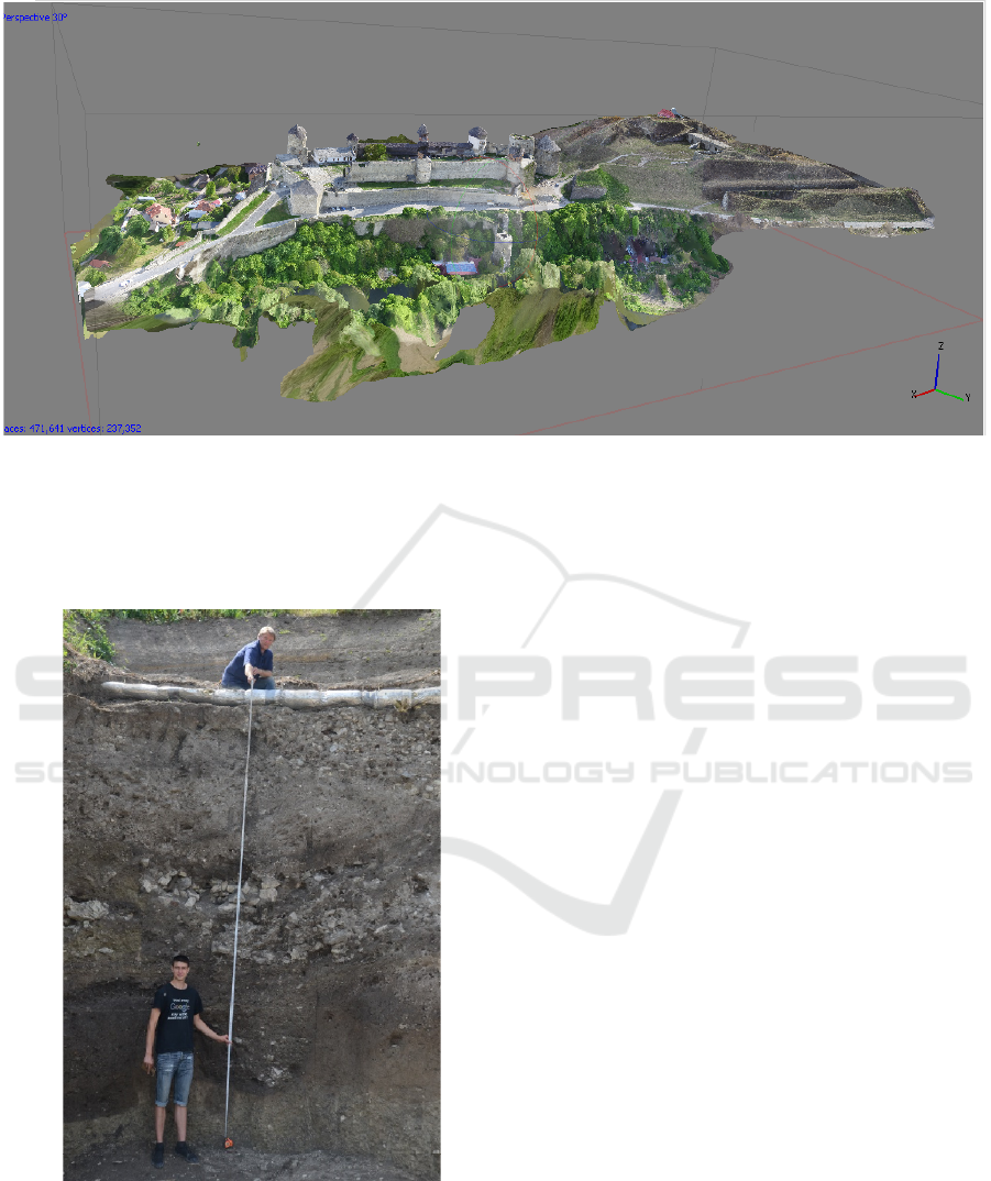
Figure 1: 3D model of the Kamyanets-Podilskyi State Historical Reserve Museum beligerative landscape complex (designed
by the authors).
The outcrop consists of 19 natural and
anthropogenic horizons and bulk layers with a
thickness of 770cm without underlying rock.
Figure 2: Visual demonstration of soil morphology with an
example of anthropogenic outcrop wall with buried soils
and urban horizons within the key point of the route.
In general, it includes: modern soil - construct soil
of 0-115cm; buried sod soil of 115-220cm; buried
construct soil of 220-345cm; fragment of buried zonal
soil type of 345-385cm; fragment of buried zonal soil
of 420-455cm; a fragment of the buried soil of the
Black Forest culture of 525-590cm; buried soil of
Trypillia culture of 590-710cm respectively.
Accordingly, the abovementioned unique features
of this outcrop make it an ideal means of
demonstrating the relationship between geological
and social history of their interaction and
complementarity.
The soil is a mirror in which all the conditions and
factors of the functioning of the landscape are
reflected. Climate information is recorded in the soil,
both directly through morphological features
(structure, color, particle size and mineralogical
composition) of buried horizons, and indirectly
through cultural and organic inclusions. Such soil
outcrops are unique records of weather conditions of
the past. Their research at different levels of soil mass
organization allows to reproduce paleogeographic
conditions, reconstruct paleolandscapes, draw
conclusions about the climate of the past and predict
future climate change in the study area.
The lithological structure as the leading object of
geotour includes rich fossils of the upper Silurian (S2)
in the Malynovets series as part of the Koniv horizon
(Holoskiv and Shutniv subhorizons) and Zvykliv
horizon (Sokilskyi subhorizon). There is a good
outcrop and easy access near the Kamyanets fortress.
Soil as an object of geotour does not work without
the correct format and forms of learning. Therefore,
we have a problem of their development and
implementation in the experimental modification of
the reference geotour, the result of which is the next
geotour.
ISC SAI 2022 - V International Scientific Congress SOCIETY OF AMBIENT INTELLIGENCE
28
The tour is focused on explaining the processes of
formation of Smotrytch canyon from the formation of
sediments in which it is laid, to the development of
modern landscapes. Basic cognitive principles on
which the explanation of complex phenomena and
processes is based are as follows – interpretation,
analogy and on-line learning. For its implementation
it is convenient to use actual visual information about
the soil cover or its mechanical (physico-chemical)
features in form of a master class.
Fossils in the structure of the Silurian sediments
are the most powerful cognitive tool and the leading
object of geotour. They are available for inspection
directly in the outcrops at the locations within the
route, and due to erosion processes can be
accumulated in the debris.
Fossil groups are clearly grouped by lithological
formations: Goloskiv subhorizon - eurypterids,
Shutnivetskyi subhorizon - corals, stromatopores,
crinoids, mosses; Sokilskyi subhorizon -
brachiopods, trilobites, gastropods, orthoceratids.
Such a grouping is due to the peculiarities of
sedimentation from the depth of the reservoir where
the formation was formed. An on-line fossil search
(fossil hunting) is used to reveal them, and an
interpretation with typical images of the Middle Ages
is used to establish cognitive value as landscape
forms such a sensory-emotional background with
fortress (Fig. 3). The route passes through various
destinations and infrastructure equipment (sidewalks,
roadsides and local sections of roads, trails and sites
of used quarries). It includes also three main
lithological locations, one introductory-explanatory
and a point for organizing a master class.
The geotour route is built on the ring principle, in
which starting point is the initial and the final one.
The most convenient one in our case is the location
between the entrance to the fortress and the car park
along the northern bastion, but there are safety
restrictions and tour participants must be moved to a
technically safe area. The area between the fortress
and the bastion, where the anthropogenic outcrop
wall is located, meets the requirements of the safe
zone. By means of this outcrop we demonstrate the
features of stay and movement within the route while
illustrating safety measures, possibility of
interpretation of the principle of stratification
sequence of construct soils, revealing the information
potential of the soil about historical events and
features of landscapes of the past.
Figure 3: Advanced interpretation stand of the route
"History of Kamyanets rocks"/(in the vulgar tongue).
An effective form of soil learning in geotour is an
on-line master class that can be implemented in the
field and in-house conditions, depending on the
course of geotour. The adaptability of master classes
increases the stability of geotour and promotes its
parallelism and nonlinearity. The field is a master
class on determining the particle size distribution of
the soil by organoleptic method. The work is carried
out with previously prepared soil samples similar in
granulometric composition to the soils of the
beligerative complex. Participants conduct
assessment of the particle size distribution of the soil
according to standard criteria for field determination
(Table 1).
Table 1: Typical indicators for field determination of
particle size distribution by organoleptic method.
Particle
size
distributi
on
Diagnostic features
Morphology of the
sample during testing
1 2 3
Sand
When moistened, a fluid
mass of "sand-spit" is
formed. Does not twist
into a cord.
Loamy
sand
Non-
p
lastic mass. Forms
cord prototype.
Geotourism as a Basis for Conserving Soils of Beligerative Complexes
29
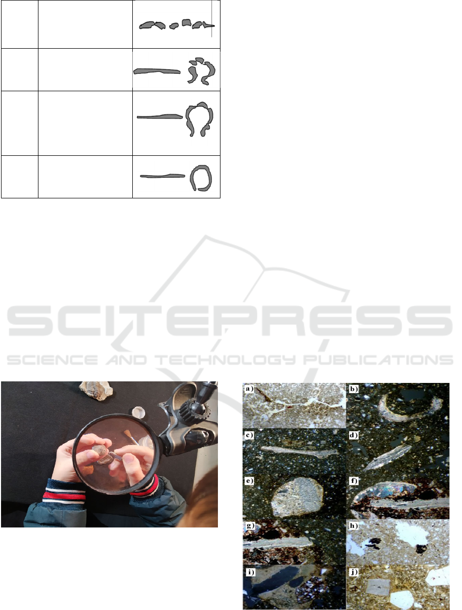
Light
loam
Slightly plastic mass.
Forms a cord that easily
breaks into pieces.
Medium
loam
Plastic mass. When
twisted, it forms a solid
cord, which disintegrates
when bent into a rin
g
.
Heavy
loam
Well-defined plastic
mass. When twisting
easily forms a cord. In
case of bending in the
ring cracks are formed
on its outer side
Clay
Good plastic sticky
mass. The cord is easily
bent into a ring without
cracks.
During the master class, participants with the help
of organoleptics through their own experience of
interaction with the soil gain a tactile understanding
of the formation of soil deposits, which are the result
of many natural and social processes. First experience
with the morphology of the samples during the tests
gives participants a clear confirmation of the valuable
material on the interaction of soil mass, lithological
basis and fortifications of the beligerative complex.
In-house master class is a work with samples to
determine the mechanical composition or slides of
soils in the laboratory, which reveals to participants
its new characteristics and creates spectacular
emotional impressions (Fig. 4).
Figure 4: Work to determine the mechanical composition of
the soil in the laboratory.
Reference samples are slides in the form of
sections with intact soil structure made in the grinding
laboratory of the M.P. Semenenko Institute of
Geochemistry, Mineralogy and Ore Formation at the
National Academy of Sciences of Ukraine.
Micromorphology provides a large amount of
objective information about the conditions of soil
formation, soil origin, intensity and ratio of the
processes that form them, physical condition and
material composition.
Working with a microscope in the laboratory
allows to observe at the microscopic level the intact
microstructure of soil deposits (Fig. 3a.), various
forms of remains of carbonate skeletons of ancient
fossilized organisms from dolomitized limestone in
several layers of soil (Fig. 3b-d.), the influence of
microorganisms on the weathering of soil-forming
rock in the soil mass (Fig. 3e-f), anthropogenic
inclusions, traces of life of ancient cultures, in
particular, Trypillia, in the form of carbonaceous
remains of plants confined to the cavity space in the
buried horizons of paleosoil (Fig. 3g), microscopic
structure of soil minerals and new Learning the
composition of the soil of the beligerative complex at
the microscopic level will form a holistic view of the
participants about the direct role of soil in archiving
landscape information and translating it into a
geological record. This form of interaction between
the participants and the soil will effectively contribute
to the understanding of its uniqueness and the
importance of conservation, which, in turn, is a
significant impetus to the popularization of soil
among the population and its protection by law
(Longhi, Trombino, Guglielmin 2021).
To define the effectiveness of these forms of
geotourism activities within the project "History of
Kamyanets rocks" (2021) test groups of different
ages, gender and social composition were polled.
Figure 5: Micromorphology of samples of laboratory
master class.
ISC SAI 2022 - V International Scientific Congress SOCIETY OF AMBIENT INTELLIGENCE
30

A total of 587 people (14 groups) were involved.
To assess the effectiveness of the participants an
anonymous survey was conducted after the geotour.
The questionnaire included the following: "Which
natural object best preserves the memory of historical
events?" and rating one (5-point grade) - "Did you
like the work in the master class?" (It was unpleasant;
I didn't like it; I don't know; It was interesting; I want
something else). Respectively, 434 (72%)
participants answered the first question with "land" or
"soil", in the case of the second – 27 (1), 59 (2), 75
(3), 189 (4), 237 (5). It is worth noting that the highest
score (5) in the case of a rating question was given
exclusively by participants under the age of 10.
The results of the introduction of the soil
component to the geotour were used in the
development and implementation of the grant project
"Project № 4REG11-03434 Terra Podolica 2021"
given by the Ukrainian Cultural Foundation.
4 SUMMARIES
Based on the study the following was found:
geotourism use of soils of beligerative landscapes is
an effective means of its conservation with economic
development at the same time. The viability of
geotourism is in its form of economic use of the soil
of the beligerative complex without direct
consumption, providing the possibility of multiple
use of the resource and its economic conversion with
the necessary conservation of natural features. This
form of soil development is the basis for its promotion
among the population and encourages the
introduction of additional protection measures;
soils within the study area are unique natural and
anthropogenic formations and are represented by
urban land and construct soils. Studies show that they
have specific morphological, micromorphological
and physicochemical features;
studies of buried soils of beligerative complexes
at different levels of soil mass organization allow to
reproduce paleogeographic conditions, reconstruct
paleolandscapes, draw conclusions about the climate
of the past and predict future climate change based on
this
soil as an object of geotour does not work without
the correct format and forms of learning;
an effective format of geotourism use of soils of
the beligerative complex is an adapted reference
geotour, expanded by the soil component;
effective forms of soil characteristics learning are
on-line master classes with development and
experimental implementation of its field and in-house
parts;
integration of soil information into geotour makes
it more adaptive, nonlinear, diversifies forms of on-
line consumer interaction with nature and ensures the
soil conservation as a natural resource of the
beligerative landscape;
in geotour the soil of the beligerative complex
plays the role of the primary link of natural-
anthropogenic interaction and is a clear
demonstration of its historical result.
REFERENCES
Bahadır, M. VeIşık, F., 2021. Geoturism potential and
Geomorphology of Fairy Chimneys in Şavşat District
(Artvin). In The Journal of Kesit Academy.
Bogutsky, A., 2018. Geotourism potential of Kremenets
mountains. In BULLETIN OF LVIV UNIVERSITY.
GEOGRAPHICAL SERIES.
Vitvitsky, Y., 2020. Regional interpretation of lithological-
paleontological structure of exposure as a condition
efficiency of geotourism product In Geotourism:
practice and experience.In Materials IV International
scientific-practical conference .
Denisyk, G., Antonyuk, O., 2017. The book Beligerative
landscapes of Podillya: Monograph. Vinnytsia.
Dmytruk, Y., Matviishyna, Z., Slyusarchuk, I., 2008. The
book, Soils of Trojan shafts: evolutionary and
ecological-genetic analysis. Chernivtsi.
Fedoronchuk, N., Yavorska, V,. Suchkov, I., 2018.
Geological information on tourist natural sites, its
importance and interpretation for a wide range of
tourists. In Geotourism: practice and experience.
Proceedings of the III International Scientific and
Practical Conference.
Longhi, A., Trombino, L., Guglielmin, M., 2021. Soil
micromorphology as tool for the past permafrost and
paleoclimate reconstruction. In CATENA
Munsell, A., 1994. The book, Munsell soil color charts.
Baltimore.
Poznyak, S., Papish, I., 2008, Soil-archaeological research
of chernozems of the late Holocene. In BUL. INST.
ARCH.
Sokolovskij, A., 1971. The book, Soil Science and
Agrochemistry. Kyiv.
Stroganova, M., 1992. Urban soils: experience of study and
taxonomy (on the example of soils in the southwestern
part of Moscow). In SOIL SCIENCE.
Targulian, V., 1978. The book, Structural and Functional
Approach to Soil: Soil-Memory and Soil-Moment.
Mathematical modeling in ecology. Moscow.
Geotourism as a Basis for Conserving Soils of Beligerative Complexes
31
