
Ontology for a Georeferencing Mobile System for Real
Time Detection and Monitoring of Wildfires
Dulce Pacheco
1,2,3 a
, David Aveiro
1,3,4 b
, Valentim Caires
1,3 c
and Duarte Pinto
1,3 d
1
ARDITI - Regional Agency for the Development of Research, Technology, and Innovation, 9020-105, Funchal, Portugal
2
School of Technology and Management, University of Madeira, Caminho da Penteada, 9020-105, Funchal, Portugal
3
NOVA-LINCS, Universidade NOVA de Lisboa, Campus da Caparica, 2829-516, Caparica, Portugal
4
Faculty of Exact Sciences and Engineering, University of Madeira, Caminho da Penteada, 9020-105, Funchal, Portugal
Keywords: Georeferencing Mobile System, Ontology, Wildfire.
Abstract: This paper presents the Georeferencing Mobile Wildfire Detection System Ontology (GeMoWilDSOn). This
ontology served as a base for implementing software for a mobile and georeferencing system for real-time
detection and monitoring of wildfires in steep mountainous territories. On average, about 65,000 fires occur
in Europe annually, burning approximately half a million hectares of wild land and forest areas. This growing
tragedy directly reduces the forest biomass and biodiversity, causing severe damage to the ecosystems.
Ontologies help developers speed up the requirements' analysis in the design of a new system. Our work
results in a streamlined ontology focused on fire prevention and fighting with mobile sensors, automatically
georeferenced polygon data, and visible and thermal image captures, specially designed for steep mountainous
terrain, where firefighting can be complex. Our research fills gaps found in related state-of-the-art and
provides innovative contributions such as the concepts of manually drawn areas of fire and shadow, which
are of utmost importance regarding this particularity of steep terrain. Our ontology was validated in three real-
world tests where experts were delighted with the features, captured information, and its representation in the
GUI of the developed system.
1 INTRODUCTION
This paper presents an ontology developed in the
context of a research project financed by European
Union funds. This ontology was a base for
implementing mobile and real-time georeferencing
software for forest fire prevention and fighting in
steep mountainous territories.
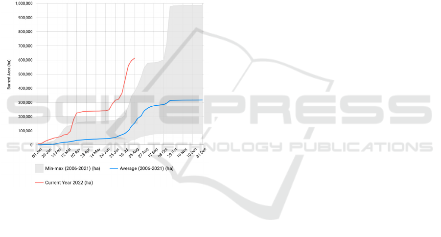
Burnt areas in Europe have increased in the last
couple of years, and up to mid-August 2022, more
area has been burnt than in the years before (see
Figure 1). On average, about 65,000 fires occur in
Europe annually, burning approximately half a
million hectares of wild land and forest areas (San-
Miguel-Ayanz, 2012). This disaster also directly
reduces the forest biomass and biodiversity, causing
a
https://orcid.org/0000-0002-3983-434X
b
https://orcid.org/0000-0001-6453-3648
c
https://orcid.org/0000-0002-0871-7212
d
https://orcid.org/0000-0002-8451-5727
severe damage to the Earth’s Forest ecosystem
(Perez-Mato et al., 2016).
Being able to promptly detect the occurrence of a
wildfire and having the capability to perform an
accurate, real-time tracking of its evolution is vital to
rapidly and efficiently organize the available
resources to control and extinguish it (Arana-Pulido
et al., 2018; Perez-Mato et al., 2016). This task can be
severely compromised in areas of steep terrain, which
not only makes the visual detection and surveillance
of the wildfire fronts or hot spots difficult but also
present localized winds and meteorological
conditions that influence the prediction of wildfire
evolution (Perez-Mato et al., 2016). The archipelagos
of Macaronesia (Freitas et al., 2019) are steep, rocky,
and with profoundly eroded lava gorges running
260
Pacheco, D., Aveiro, D., Caires, V. and Pinto, D.
Ontology for a Georeferencing Mobile System for Real Time Detection and Monitoring of Wildfires.
DOI: 10.5220/0011592100003335
In Proceedings of the 14th International Joint Conference on Knowledge Discovery, Knowledge Engineering and Knowledge Management (IC3K 2022) - Volume 2: KEOD, pages 260-268
ISBN: 978-989-758-614-9; ISSN: 2184-3228
Copyright
c
2022 by SCITEPRESS – Science and Technology Publications, Lda. All rights reserved
down to the sea, which makes the fires' fronts
challenging to spot and monitor.
Several key technologies and methods are
commonly used for wildfire detection, surveillance,
and prediction (Perez-Mato et al., 2016). These
methods include fixed and mobile ground-based
solutions, aerial platforms, and satellite imaging or
sensing (Perez-Mato et al., 2016). However, most of
them have specific limitations that might affect their
performance and the usefulness of the generated
information (Perez-Mato et al., 2016). Furthermore,
algorithms used to predict wildfire spread relies on
accurate near real-time input data to maximize their
reliability (Perez-Mato et al., 2016). Unfortunately,
most previously described technologies cannot
provide data quickly or accurately enough (Perez-
Mato et al., 2016).
Figure 1: EFFIS Weekly Cumulative Burnt Areas in
Europe, in 2022.
The georeferencing of the wildfire could also see
some improvements. Most ground and airborne
solutions only provide images of the fire, captured by
thermographic or visual cameras, and leave the fire
georeferencing task to the staff supervising those
images (Perez-Mato et al., 2016). This adds a manual
step to the process, which can be very slow and
inaccurate in most cases, severely affecting the rapid
decision-making scenarios required during a wildfire
extinction process (Perez-Mato et al., 2016).
Perez-Mato and colleagues introduced a rapidly
deployable mobile unit (RDMU) prototype. It uses a
thermographic camera to autonomously detect, track,
and georeference wildfires within its detection range
(Perez-Mato et al., 2016). The data collected by these
RDMUs is complex, needs to be safely kept, and be
rapidly available for the firefighting staff members,
both in real-time, to help in the fire extinguishing
efforts, and a posteriori, to analyze the wildfire
progression and behavior.
The list of requirements for the functionality of
fire safety systems has been increasing in the last
couple of years, while the time of implementation of
software projects has been reduced (Nikulina et al.,
2019). Ontologies may help developers speed up the
requirements analysis in the design of a new system.
Furthermore, ontologies may contribute to solving
the problem of integrating knowledge from various
sources and presenting it by subject area in an explicit
form (Nikulina et al., 2019). In turn, it facilitates
knowledge development, understanding, and
maintenance, reducing duplications and
inconsistencies (Nikulina et al., 2019).
This paper presents the ontology designed to
formalize information supplied by a set of RDMUs,
as well as decisions and commands issued by the
intervenients. All information and commands are
made available according to the needs of staff in an
intuitive GUI.
The following sections present: the context of our
work; a review of related work regarding ontologies
for fires and sensors-based systems; our ontology
proposal, which addresses the concrete needs of our
practical project and its validation; a comparison
between our approach and related work; and
conclusions and future work.
2 SENSOR-BASED WILDFIRES
DETECTION SYSTEMS
This section overviews the most widely used sensor-
based wildfire detection systems. Most of these
systems may also serve as: (1) tracking tools once the
fire has started; or (2), in a post-fire moment, for
firefighting staff and investigators to go back in the
data and analyze the fire progression. The main
features and limitations of these systems are
presented.
2.1 Ground Detection Systems
Fire detection systems based on the ground are
usually composed of cameras attached to
watchtowers or similar infrastructures, which can
provide the necessary power and communication
interfaces (Perez-Mato et al., 2016). To be able to
surveil large extensions of a forest, several of these
observation points need to be installed, ideally
accounting for the field of view (FOV) of each
Ontology for a Georeferencing Mobile System for Real Time Detection and Monitoring of Wildfires
261

camera and considering the individual pan and tilt
ranges, as well as the presence of any surrounding
obstacles (Perez-Mato et al., 2016).
According to the literature (Perez-Mato et al.,
2016), ground-based wildfire detection systems
present the following main limitations: (1) cameras
are permanently exposed to weather conditions and
are prone to vandalism, which demands regular and
pricey maintenance to keep the cameras operational;
(2) the limited FOV demands numerous observation
points to cover a large area; (3) the georeferencing of
the detected fire is usually performed manually by
firefighting staff, which is prone to error.
An alternative to ground-based wildfire detection
systems is vehicles with thermographic cameras
installed. This configuration increases the mobility
and reconfigurability of the observation points and
reduces the possibility of damage caused by weather
and vandalism (Perez-Mato et al., 2016). However,
they still suffer from the same subjectivity regarding
wildfire georeferencing and pose a high risk for
vehicle operators (Perez-Mato et al., 2016).
2.2 Aerial Detection Systems
Human-crewed helicopters and aircraft are often used
during wildfires for firefighting and monitoring tasks,
as they can spray water over the fire and serve as
high-altitude observation points (Perez-Mato et al.,
2016). Aircraft flying over a wildfire area provides a
much larger FOV and can be dynamically moved
from one place to another as the wildfire evolves.
This makes them much more versatile and efficient
than ground-based solutions (Perez-Mato et al.,
2016).
The main limitation posed by these systems is the
danger to the aircraft crew due to the proximity to the
active fire and local turbulence, which may affect the
aircraft’s stability (Perez-Mato et al., 2016). This has
been a direct consequence of many fatal accidents in
the past.
Uncrewed Aerial Vehicles (UAVs) are now
widely used for monitoring tasks under risky
situations (Perez-Mato et al., 2016). However, there
is concern about addressing a loss of control if they
share the same airspace with crewed aircraft (Perez-
Mato et al., 2016). Other typical limitations of
commercially available UAVs are their limited
autonomy, low payload capacity, and limited ability
to withstand strong winds or turbulence (Perez-Mato
et al., 2016).
Wildfire tracking using satellite imagery and
multispectral sensing has often been employed when
large extensions of land or forest are affected by a
severe fire (Perez-Mato et al., 2016). The primary
limitations associated with satellite-based remote
sensing are the time it takes for the image to be
available to the firefighters' staff and the low
periodicity of images captured (Perez-Mato et al.,
2016).
3 RELATED WORK
This section presents the most relevant ontologies
within the scope of our project.
3.1 Ontologies of Fire Prevention
Systems
The literature presents a few ontologies in the field of
fire prevention and safety. A review of this field was
compiled by Nikulina and colleagues (Nikulina et al.,
2019). Some ontologies (Chandra et al., 2022;
García-Castro & Corcho, 2008; Souza, 2014) are
concerned with wildfires, while others focus on fires
in buildings (Bitencourt et al., 2018; Fitkau &
Hartmann, 2021; Nunavath et al., 2016; Tay et al.,
2016).
3.1.1 Wildfires
An ontology of a Semantic Sensor Network for Forest
Fire Management was presented in a study to
semantically enhance fire detection alert inference
methods by integrating meteorological information
and deep knowledge mining from observational data
(Chandra et al., 2022). The authors (Chandra et al.,
2022) discovered that the system's running time rises
while processing large ontologies owing to the
enormous amount of information, which indicates
that the framework's scalability must be improved.
Researchers (Chandra et al., 2022) have considered
adopting similar processing techniques, allowing
several processors to examine various portions of the
ontologies concurrently, improving the execution
time.
The Fire Ontology Network (García-Castro &
Corcho, 2008) and the Fire Ontology (Souza, 2014)
are intended to fight forest fires and address the use
case of wildland fire risk management. However,
some parts of these ontologies may be used for other
purposes, such as fires in buildings.
The Fire Ontology (Souza, 2014) represents the
set of concepts about the fire occurring in natural
vegetation, its characteristics, causes, and effects,
focusing on the Cerrado vegetation domain. There are
53 classes and 19 properties in this ontology. It
KEOD 2022 - 14th International Conference on Knowledge Engineering and Ontology Development
262

focuses on fire characteristics like area burned, fire
frequency, fire intensity, fire severity, flame height,
speed, and spread.
The Fire Ontology Network (García-Castro &
Corcho, 2008) supports the project use case on forest
fire risk management. This approach mainly reuses
SWEET ontology (ESIP Semantic Team, 2022),
which covers the following domains: fire, forest and
vegetation, weather, geography, water body,
infrastructure, location, and time. A SpatialObject
class was added to represent objects that have a
location, classes were identified to be considered as
spatial objects (bodies of water, landforms,
infrastructures, and fire), and the definition of
datasets (to make them cover a region and a temporal
extent) was extended (ESIP Semantic Team, 2022).
3.1.2 Fires in Buildings
The approaches Emergency Fire Ontology
(Bitencourt et al., 2018), Building Fire Emergency
Response (BFER) (Nunavath et al., 2016), and
Building Ontology (Tay et al., 2016) propose
ontologies for emergency fire situations, especially in
buildings. They describe the emergency protocols
aiming to enable end-users to respond quickly to fire
emergencies in facilities. However, they do not focus
on preventive fire safety.
The Preventive Fire Safety Ontology (PrevFis)
contains general descriptions which present the
topology of a building, as well as part of preventive
fire safety, which is crucial for structural fire safety
(Fitkau & Hartmann, 2021). Fitkau and Hartmann
(2021) describe a general ontology based on a
detailed rule-based data source, using the ontology
development METHONTOLOGY (Fernández-
López et al., 1997). This work (Fitkau & Hartmann,
2021) reports on real-world use cases successfully
presented and concluded in PrevFis, collected in close
cooperation with fire safety specialists.
3.2 Ontology of Sensor-based Systems
The Semantic Sensor Network (SSN) is an ontology
developed by a W3C group for describing sensors and
their observations, the involved procedures, the
studied features of interest, the samples used to do so,
the observed properties, and actuators (Haller et al.,
2017). SSN follows a horizontal and vertical
modularization architecture by including a
lightweight but self-contained core ontology for its
elementary classes and properties, called SOSA
(Sensor, Observation, Sample, and Actuator) (Haller
et al., 2017). With their different scope and different
degrees of axiomatization, SSN and SOSA can
support a wide range of applications and use cases,
including satellite imagery, large-scale scientific
monitoring, industrial and household infrastructures,
social sensing, citizen science, observation-driven
ontology engineering, and the Web of Things (Haller
et al., 2017).
4 PROPOSED ONTOLOGY
4.1 Research Approach
Our proposed ontology of a georeferencing mobile
wildfire detection and monitoring system was
designed with the help of experts in the field of
wildfire detection, prevention, and fighting, who
were involved in the evaluation of each iteration. The
initial core of our ontology was based on previous
work on wildfire ontologies (Chandra et al., 2022;
García-Castro & Corcho, 2008; Souza, 2014) and the
SSN ontology (Haller et al., 2017). Thus, the
alignment of the asserted knowledge was an
incremental process built over several iterations.
The development of this ontology was based on
METHONTOLOGY, a well-known methodology
used to build ontologies from scratch (Fernández-
López et al., 1997). It identifies a set of activities
during the ontology development process: planify,
specify, acquire knowledge, conceptualize,
formalize, integrate, implement, evaluate, document,
and maintain. METHONTOLOGY proposes the
following steps: specification, conceptualization,
formalization, integration, implementation, and
maintenance (Fernández-López et al., 1997).
In communication with the domain experts, an
initial conceptual model was developed , using the
traditional Entity Relationship notation (Chen, 1976)
and methods of DEMO and Enterprise Engineering,
namely the Organizational Essence Revealing (OER)
method (Dietz & Mulder, 2020). The knowledge
represented in the initial conceptualization was then
formalized in a more detailed way in an ontology
represented in the Concepts and Relationships
Diagram (CDR) (Gouveia et al., 2021; Pacheco et al.,
2022), an adaptation of the diagram of the Generic
Ontology Specification Language presented in Dietz
and Mulder (2020).
The CDR is a generic, global, and synthetic view
of an entire domain’s concepts while abstracting from
their attributes (Pacheco et al., 2022). In the CDR, a
concept is represented by a collapsible box whose
expansion discloses its attributes, one per line. The
value type of an attribute is specified to the left of the
Ontology for a Georeferencing Mobile System for Real Time Detection and Monitoring of Wildfires
263
line, while to the right is the attribute's name. The
value type can be any of the following options:
category, reference, document, text, doc & text,
number, date, or boolean. Arrows express
relationships, which will always consist of an
attribute in one concept whose instances will
reference instances of the other concept. Cardinalities
are represented with arrows pointing to relationships’
“one side”. A dark-filled circle attached to a concept
in one connector means that an instance of this
concept, in order to exist, depends on an instance of
the concept at the other end of the connector (Gouveia
et al., 2021). The specialization/ generalization
relationship is depicted using a connector with a
pointed line (Gouveia et al., 2021; Pacheco et al.,
2022).
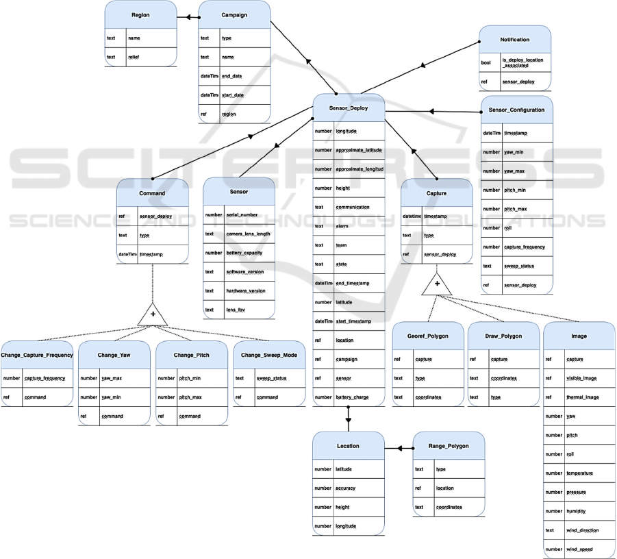
In Figure 2, we can find our ontology's concepts,
relationships, and attributes, together with their value
types, essential for implementing software systems.
4.2 Ontology Description
Our proposal constitutes a Georeferencing Mobile
Wildfire Detection System Ontology
(GeMoWilDSOn). This ontology covers a mobile
system's classes, concepts, and attributes to detect,
monitor, and prevent wildfires. The GeMoWilDSOn
includes information on the sensors, their
configurations, deployments, geographic regions,
campaigns, notifications, logs of executed
commands, locations, and captures (georeferenced
polygons, drawn polygons, and images).
Figure 2: Concepts and Relationships Diagram.
KEOD 2022 - 14th International Conference on Knowledge Engineering and Ontology Development
264

The concept Region refers to a specific
geographic area where the Wildfire Detection System
will be used, the relevant attributes are the name of
said region and the relief, that is, the type of terrain in
said region.
A Campaign is an organized fire prevention
activity in a set period (with a start and end date), that
applies to a specific Region.
The Wildfire Detection System has as one of its
primary tools Sensors (which include the ability to get
visible and thermal images of the terrain). Each of
these Sensors has a set of intrinsic properties of the
equipment, namely serial number, a software and
hardware version, a specific camera lens length
specification, the expected field of view of the lens,
and the battery capacity.
The concept of Sensor Deploy regards the use of
the before-mentioned Sensors in specific Campaigns,
deployed in a given Location within the region. These
deployments take place within a specific timeframe
(that can be the same as the Campaign itself) and
therefore need a start and end timestamp. Other
relevant attributes include: the latitude and longitude
where it has been deployed (as well as a less exact
approximation of said latitude and longitude); the
specific height of the deployment; the type of the
communication (for example, medium band); the
alarm identification code; the team responsible for the
deployment of that sensor; the current battery levels;
and the state of the deployment (if it is ongoing, has
ended or has any issues).
Each Sensor Deploy also needs a Sensor
Configuration where the parameterization for that
specific Sensor is set, although, during the
deployment time, this configuration may be changed
multiple times. The Sensor Configuration includes a
timestamp of when it took place, a yaw and pitch
range, a set roll (movement and position of the sensor
within its axis), a capture frequency for the polygons
and images, and the sweep status (if it is in sweep or
fixed mode).
Despite the default Sensor Configuration, it is
also possible to send specific Commands to take
effect in the Sensor Deployment. These Commands
can be of four different types; 1) Change the Capture
Frequency, where the time between captures can be
altered; 2) Change Yaw, where the range of the Yaw
rotation can be modified; 3) Change Pitch, where the
range of rotation of the Pitch can be changed; and 4)
Change Sweep Mode where the type of Sweep mode
can be changed.
When a Sensor Deploy is in use and depending on
the set Capture Frequency, the Sensor will make
multiple image captures. These Images contain
multiple attributes, namely, the visible image, the
thermal image, the yaw, pitch, and roll of when it took
place, the temperate, pressure, and humidity of the
area, as well as wind direction and speed. These
captures are processed by georeferencing algorithms
that take information from the thermal image,
position of the sensor, and terrain information,
namely contour lines, to produce polygons that
represent areas that are for sure covered by fire and
shadow areas that, due to the steepness of the
mountains, one cannot be sure that fire is there or not.
In the georef polygon concept, the attribute type
indicates if the area is of type fire or shadow.
Operators may complement the capture with
manually drawn polygons, both of fire and shadow
types. Experienced fire prevention and fight
coordinators will know, considering fire progression,
local meteorological conditions, knowledge of the
terrain, and other direct observations (by aircraft
pilots, for example), how to complement the
automatically identified fire and shadow areas. Such
complementary information is essential for a more
informed evolution of the fire and necessary decisions
on how to allocate firefighting resources and possible
changes of the sensors' positions. These
modifications, might allow a complete view of the
situation and more effective automatic generation of
fire and shadow areas by the algorithms.
The concept of Location, before mentioned in the
Sennsor Deploy, also has its own set of attributes with
the latitude, longitude, height, and accuracy that are
optimal for sensor deployment in said location. This
optimal location may or may not be used in a specific
deployment due to logistic reasons.
Each Location can also have a Range Polygon
associated, which is a polygon that delimits the total
visible area that the sensor can capture, considering
the surrounding topography, like mountains that
could block the view. This information is mainly used
to pick the best location for deploying each sensor,
maximizing the covered area.
The final concept is the Notification, which
reports the association of a Sensor Deployment and a
specific predetermined Location (or not).
4.3 Validation
The ontology was validated in real-world tests that
took place in three archipelagos in Macaronesia:
Cabo Verde, Madeira, and Canaries. These tests
relied on the involvement and contribution of teams
of experts from different local wildfire prevention and
fighting services, in particular, Instituto das Florestas
e Conservação da Natureza (Madeira), Cabildo de
Ontology for a Georeferencing Mobile System for Real Time Detection and Monitoring of Wildfires
265

Gran Canaria (Canaries), and Serviço Nacional de
Proteção Civil e Bombeiros (Cabo Verde).
A complete hardware and software system was
developed, allowing real-world tests and ontology
validation. Figure 3 shows a diagram of the system's
architecture.
Figure 3: Architecture of the system.
The system’s hardware is constituted by a set of
mobile sensors (cameras that capture both visual and
thermal images) and two web servers. One of the
servers, implemented by our project partner, handles
sensor information processing and command
reception. The other server, developed by us,
aggregates the database, sensor information reception
interface as well as a GUI component.
The GUI is composed of three visors. The
MainVisor shows a satellite or contour line view of
the terrain, as well as real sensor positions (camera
symbols), their range of observation, and fire and
shadow polygons, both the automatically generated
and the drawn ones. In a layer selection feature, one
can choose to see all types of polygons or just a few.
This visor also has a timeline feature where one can
navigate through a set time interval, to view, analyze,
and eventually draw/edit/delete the polygons. The
NodeVisor displays more detailed information about
the selected sensor and also allows the user/operator
to send commands to change some of its settings. The
ImageVisor shows the images, both visible and
thermal, that were captured by the selected sensor in
the time and date that is currently selected in the
timeline navigation bar. Figure 4 shows a screenshot
of the main GUI.
Figure 4: System’s GUI with thermal image.
The real-world tests in the three Macaronesian
regions started in Santiago Island (Cabo Verde), in
June 2022, focusing on the mobile device itself.
Around 40 participants were involved in these tests.
In August 2022, the tests took place in Madeira Island
where the integrated testing of the entire system was
carried out for the first time, including the sensors and
the two web servers. The tests in Madeira included
around 25 participants. The entire system was
improved based on the experience acquired, and the
final test occurred in September 2022, in Gran
Canaria (Canary Islands). In this last field test,
participated six fire prevention and fighting experts,
representing the three regions involved in the project.
The last two tests included the detection of
wildfire ignitions by the system and the analysis, by
the experts in fire prevention and fighting, of the:
comprehensiveness and completeness of the data
collected, and the functionalities of the GUI.
The feedback given both on the system's ontology
and functioning was very positive, and experts did not
identify any missing information.
4.4 Discussion
Our work proposes the GeMoWilDSOn, an ontology
for georeferencing mobile wildfire detection and
monitoring systems. We foresee that the number of
different mobile sensor-based systems to detect and
monitor fires will increase shortly. In our search for
existing ontologies in the scope of our work, we
verified that a few ontologies existed regarding fires,
but none foreseeing mobile georeferencing of fires
based on thermal images and terrain information. Fire
Ontology (Souza, 2014) and Fire Ontology Network
(García-Castro & Corcho, 2008) focus mainly, or
only on fire, natural resources, and infrastructure
concepts. Semantic Sensor Network Ontology (Haller
et al., 2017) and Semantic Sensor Network for Forest
Fire Management (Chandra et al., 2022) are primarily
focused on the sensors’ domain. These ontologies are
somewhat generic, complex, and more of a normative
kind, giving freedom for implementation. They do not
easily translate to a streamlined data model that can
be efficiently implemented in a real-time system
where fast performance is essential and of utmost
value.
Although a sensor-based approach like the one
proposed by Chandra and colleagues (2022), with
bases on SSN and SOSA, can be highly versatile and
used in practically any domain where sensors are
involved, the fact of being so generic also means it is
not optimized for any particular scenario.
KEOD 2022 - 14th International Conference on Knowledge Engineering and Ontology Development
266

GeMoWilDSOn was tailored for forest fires' fight
and prevention with sensors that capture images and
georeferentiation. It can be easily adapted to expand
the range of sensors/capabilities for other contexts, if
so is necessary. Nevertheless, as it is,
GeMoWilDSOn was based and is totally aligned with
the classes prescribed in the sensor-based approach
regarding our implementation scope, thus making our
solution grounded and validated according to the
state-of-the-art.
Our proposal of the GeMoWilDSOn fills the
found gaps in state-of-the-art by being an ontology
that encompasses both the fire and sensor domains in
a streamlined way. This ontology was already
validated in real tests in the field with a software
system close to being completed. An important
innovation and research contribution of our ontology
is the possibility of complementing captured
information and georeferenced polygons with
manually drawn polygons to complement
automatically generated information.
5 CONCLUSIONS AND FUTURE
WORK
This paper presents GeMoWilDSOn, an ontology for
georeferencing mobile wildfire detection and
monitoring systems. We analyzed related work in the
context of our practical research project for
developing an innovative mobile sensor-based
system with associated APIs, database, and GUI. We
identified some concepts in previous work, but we
needed to introduce innovative ones and simplify
some views of related work. The result is a
streamlined ontology focused on fire prevention and
fighting with mobile sensors, specially designed for
steep mountainous terrain, where firefighting can be
complicated and complex. The innovative
contribution of manually drawn areas of fire and
shadow is of utmost importance concerning the
particularities of steep terrain.
Our ontology was validated in three real-world
tests where experts were delighted with captured
information and its representation in the GUI of the
developed system.
Our project is currently in its final stages. We are
now implementing the final task consisting of a
sensor location management and advisor component.
With this new component, it will be possible to
manually add to the system possible preferred and
advisable locations to deploy the mobile sensors.
Another important feature will be the possibility of
the system, considering current fire and shadow areas,
as well as terrain contour lines, to automatically
advise changes of sensor locations, so those shadow
areas (and the size of shadows) are reduced. Thus fire
areas will be more clearly identified and represented.
We expect to extend our proposed ontology with new
concepts needed for these practical features.
Another line of future work that we foresee, in the
context of a subsequent research project, is the
inclusion of UAV-based sensors. Very recent
developments in UAV technology in terms of
stabilization and autonomy will allow the integration,
in our architecture, of information provided by these
aerial sensors. Hence, allowing for a completer
information on fire location and evolution and
improving the overall effectiveness of our system,
fire prevention, and fight in general.
ACKNOWLEDGEMENTS
Special thanks to the participants in the study that
contributed with their fruitful insights and feedback.
This work was supported by the Regional
Development European Fund (INTERREG MAC),
project GesFoGO MAC/3.5b/227 (MAC-2014-
2020).
REFERENCES
Arana-Pulido, V., Cabrera-Almeida, F., Perez-Mato, J.,
Dorta-Naranjo, B. P., Hernandez-Rodriguez, S., &
Jimenez-Yguacel, E. (2018). Challenges of an
autonomous wildfire geolocation system based on
synthetic vision technology. Sensors (Switzerland),
18(11). https://doi.org/10.3390/s18113631
Bitencourt, K., Araújo Durão, F., Mendonça, M., & Laique
Bomfim de Souza Santana, L. (2018). An ontological
model for fire emergency situations. IEICE
Transactions on Information and Systems, E101D(1),
108–115.
https://doi.org/10.1587/transinf.2017SWP0003
Chandra, R., Abhishek, K., Agarwal, S., & Singh, N.
(2022). Semantic Sensor Network Ontology based
Decision Support System for Forest Fire Management.
ArXiv, 1–20.
https://doi.org/10.48550/arxiv.2204.03059
Chen, P. P. S. (1976). The Entity-Relationship Model—
toward a Unified View of Data. ACM Transactions on
Database Systems (TODS), 1(1), 9–36.
https://doi.org/10.1145/320434.320440
Dietz, J. L. G., & Mulder, H. B. F. (2020). Enterprise
Ontology: A Human-Centric Approach to
Understanding the Essence of Organisation. Springer
Ontology for a Georeferencing Mobile System for Real Time Detection and Monitoring of Wildfires
267

International Publishing. https://doi.org/10.1007/978-
3-030-38854-6
EFFIS Weekly Cumulative Burnt Areas. (n.d.). Retrieved
August 12, 2022, from
https://effis.jrc.ec.europa.eu/apps/effis.statistics/season
altrend/EU
ESIP Semantic Team (2022). Semantic Web for Earth and
Environment Technology Ontology - SWEET.
https://bioportal.bioontology.org/ontologies/SWEET
Fernández-López, M., Gómez-Pérez, A., & Juristo, N.
(1997). METHONTOLOGY: From Ontological Art
Towards Ontological Engineering. Engineering
Workshop on Ontological Engineering (AAAI97).
Fitkau, I., & Hartmann, T. (2021). Building Ontology for
Preventive Fire Safety. EG-ICE 2021 Workshop on
Intelligent Computing in Engineering, Proceedings, 8,
0–9.
Freitas, R., Romeiras, M., Silva, L., Cordeiro, R., Madeira,
P., González, J. A., Wirtz, P., Falcón, J. M., Brito, A.,
Floeter, S. R., Afonso, P., Porteiro, F., Viera-
Rodríguez, M. A., Neto, A. I., Haroun, R., Farminhão,
J. N. M., Rebelo, A. C., Baptista, L., Melo, C. S., …
Ávila, S. P. (2019). Restructuring of the ‘Macaronesia’
biogeographic unit: A marine multi-taxon
biogeographical approach. Scientific Reports, 9(1), 1–
18. https://doi.org/10.1038/s41598-019-51786-6
García-Castro, R., & Corcho, O. (2008). Fire Ontology
Network.
http://linkeddata4.dia.fi.upm.es/ssg4env/index.php/ont
ologies/12-fire-ontology-network/default.htm
Gouveia, B., Aveiro, D., Pacheco, D., Pinto, D., & Gouveia,
D. (2021). Fact Model in DEMO - Urban Law Case and
Proposal of Representation Improvements. Lecture
Notes in Business Information Processing, 411, 173–
190. https://doi.org/10.1007/978-3-030-74196-9_10
Haller, A., Janowicz, K., Cox, S., Phuoc, D. Le, Taylor, K.,
& Lefrançois, M. (2017). Semantic Sensor Network
Ontology. W3C Recommendation.
https://www.w3.org/TR/vocab-ssn/
Nikulina, Y., Shulga, T., Sytnik, A., Frolova, N., &
Toropova, O. (2019). Ontologies of the Fire Safety
Domain. In O. Dolinina, A. Brovko, V. Pechenkin, A.
Lvov, V. Zhmud, & V. Kreinovich (Eds.), Studies in
Systems, Decision, and Control (Vol. 199, pp. 457–
467). Springer. https://doi.org/10.1007/978-3-030-
12072-6_37
Nunavath, V., Prinz, A., Comes, T., & Radianti, J. (2016).
Representing Fire Emergency Response Knowledge
Through a Domain Modelling Approach. NOKOBIT
2016, 24(1), 28–30.
Pacheco, D., Aveiro, D., & Pinto, D. (2022). Evaluation of
the perceived quality and functionality of Fact Model
diagrams in DEMO. Lecture Notes in Business
Information Processing, 3, 1–19.
Perez-Mato, J., Arana, V., & Cabrera-Almeida, F. (2016).
Real-time autonomous wildfire monitoring and
georeferencing using rapidly deployable mobile units.
IEEE Aerospace and Electronic Systems Magazine,
31(2), 6–15.
https://doi.org/10.1109/TAES.2016.150057
San-Miguel-Ayanz, J., Schulte, E., Schmuck, G., Camia,
A., Strobl, P., Liberta, G., Giovando, C., Boca, R.,
Sedano, F., Kempeneers, P., McInerney, D., Withmore,
C., de Oliveira, S. S., Rodrigues, M., Durrant, T., Corti,
P., Oehler, F., Vilar, L., & Amatulli, G. (2012).
Comprehensive Monitoring of Wildfires in Europe:
The European Forest Fire Information System (EFFIS).
Approaches to Managing Disaster - Assessing Hazards,
Emergencies and Disaster Impacts, May 2014.
https://doi.org/10.5772/28441
Souza, A. (2014). Fire Ontology.
https://bioportal.bioontology.org/ontologies/FIRE
Tay, N. N. W., Kubota, N., & Botzheim, J. (2016). Building
Ontology for Fire Emergency Planning and Support. E-
Journal of Advanced Maintenance, 8(2), 13–22.
KEOD 2022 - 14th International Conference on Knowledge Engineering and Ontology Development
268
