
Research on Digital Governance of Rural Environment Based
on Cesium for Unreal
Wei Hu
*
, Dandan Liu, Poyu You, Jian Zhao, Hao Du and Hui Zhang
Guizhou Electric Power Design Research Institute Co., Ltd., Power Construction Corporation of China, Guiyang 550002,
China
Keywords: Cesium for Unreal, Rural Environment, Digital Governance.
Abstract: Rural environmental governance is an important national development strategy, and with the application of
network, informatization and digitization in agricultural and rural economic and social development, the
digital governance of rural environment has become a research hotspot (Association I, Maclennan B L,
Bergeron S J.2019). Therefore, this paper introduces cesium technology and UE4 technology into the digital
governance of rural environment, in order to realize the combination of virtual and real, the virtual scene as a
reference to the real scene, and the real scene transmits data to the virtual scene, so as to realize the real
meaning of data-driven two-way interaction, so as to realize the digitization and visualization of rural
environmental governance.
1 INTRODUCTION
The report of the 19th National Congress of the
Communist Party of China clearly pointed out that
the implementation of Rural Revitalization Strategy,
and gradually realize the sustainable development of
ecological civilization (Liu, Liu, Jing, et al. 2012). At
the same time, "opinions on Rural Revitalization
Strategy" and "Rural Revitalization strategic
planning (2018-2020)" also put forward that Rural
Revitalization Strategy should be implemented, and
rural environmental governance is the only way to
implement Rural Revitalization Strategy (Ren 2021),
and good environment is an important foundation
and guarantee for the development of rural economy
(Du 2021). The comprehensive governance of rural
ecological environment is the only way to realize the
green agricultural production and low-carbon
agricultural life, and then realize the transformation
of rural economic development (Gao 2018). The
environmental governance of hometown village is an
important national development strategy, and
accompanied by the application of network,
informatization and digitization in the development
of rural economy and society, Digital governance of
rural environment has become the focus of current
research (M A, Zhang, Liu 2019).
Therefore, this paper first introduces the latest
digital technology of 3D scene representation,
namely cesium for unreal, which combines the 3D
geospatial function of cesium with the high fidelity
rendering ability of virtual engine 4 (UE4). The
combination of cesium technology and virtual engine
4 technology realizes the creation of 3D environment
from real to digital. Then, the digital and visual
construction of rural environment is realized by using
cesium for unreal technology. The construction
results of this paper will help policy makers
intuitively and comprehensively understand the
situation of rural environmental governance, quickly
grasp the overall situation of the target area, and be
conducive to the digital governance of rural
environment.
2 MATERIALS AND METHODS
2.1 Cesium
Cesium is a world-class JavaScript open source
product for 3D Earth and maps (Peng Xiang. 2021).
Used to render 3D Earth, 2D area maps, and a variety
of GIS elements. It provides a development kit based
on JavaScript language, which makes it convenient
for users to quickly build a zero-plug-in virtual earth
Web application, and has a high quality guarantee in
Hu, W., Liu, D., You, P., Zhao, J., Du, H. and Zhang, H.
Research on Digital Governance of Rural Environment Based on Cesium for Unreal.
DOI: 10.5220/0011769100003607
In Proceedings of the 1st International Conference on Public Management, Digital Economy and Internet Technology (ICPDI 2022), pages 841-845
ISBN: 978-989-758-620-0
Copyright
c
2023 by SCITEPRESS – Science and Technology Publications, Lda. Under CC license (CC BY-NC-ND 4.0)
841
performance, accuracy, rendering quality, multi-
platform and ease of use.
Use Cesium to quickly load all kinds of base
maps, including WMS service, xyz format base map,
arcgis server, load single picture, load sky map image,
load sky map electronic map, load Gaud image, load
Google image map, etc.; at the same time, you can
also use Cesium to quickly realize length
measurement, area measurement, dimension line
drawing, dimension surface drawing; set roaming
path; rain and snow weather effect; split screen effect;
illumination simulation. Simulated demolition and
other functions. Using Cesium, we can quickly stack
artificial models and all kinds of vector data. As an
open source 3D display technology, Cesium provides
a display engine for digital rural construction.
2.2 UE4
UE4 is a popular game development engine all over
the world (Tian 2021). The Unreal engine is a
complete set of integrated tools for building games,
simulation and visualization, with sufficient
flexibility to meet the needs of development teams of
different sizes (Wang 2021). Unreal engine is the
most open and advanced real-time 3D creation
platform in the world. After continuous improvement,
it is not only a temple-level game engine, but also
brings unlimited creative freedom and
unprecedented control to professionals in various
industries. Whether it's cutting-edge content,
interactive experiences, or immersive virtual worlds,
it's all in the illusory engine.
The Unreal engine is a palace-level real-time
engine and editor, with photo-level realistic
rendering functions, dynamic physics and effects,
lifelike animation, robust data conversion interface
and so on. It is an open and extensible platform that
can bring you unlimited creative freedom.
With the unprecedented demand for real-time 3D
technology in digital countryside, learning illusory
engine has become the best way to expand digital
countryside.
2.3 Cesium for Unreal
Cesium for Unrea, which was officially released in
2021-03-30, is a 3D Earth plug-in tailored by Cesium
for the illusory engine, which makes the unreal
engine have the ability of Google Earth and opens a
new door for simulating the real world. Cesium for
Unreal, based on open standards and API, combines
the 3D geospatial capabilities of Cesium with the
high-fidelity rendering capabilities of Unreal engines
to open the 3D geospatial ecosystem for game
engines. Cesium for Unreal enables you to create a
digital world from real-world 3D content, and use
Cesium for Unreal to create a digital world with real-
world scale and 3D content.
3 RESEARCH ON DIGITAL
CONSTRUCTION OF RURAL
ENVIRONMENT BASED ON
CESIUM FOR UNREAL
Based on cesium for unreal, the research of rural
environment digital construction is realized by
designing a three-dimensional visualization system
(Wang, Li, Zhang, Chen, Yang, Yu 2021). The
design idea of the system, first of all, the rural
environment big scene data collection and important
facilities refinement model, and then data format
conversion, using the cesium for unreal import data,
combined with blueprint interactive function and
front-end display function, realize the digital display
of rural environment (Wang, Li, Fan 2020). Finally,
through the collected sensor data and scene digital
information, based on the principle of Bryson
collaborative governance model, the environmental
governance function is developed, the factors of the
effectiveness of the target rural environmental
governance are extracted, and the governance
strategies are formulated through human-computer
interaction to provide the basis for environmental
governance.
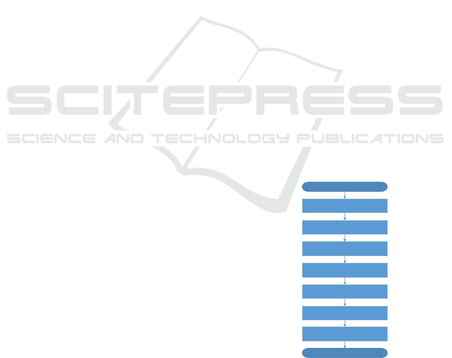
START
Data collection of real large
scene in rural area
Establishment of fine model of
important facilities
Format conversion
Import with Cesium for Unreal
Blueprint interaction
Use pixel streaming to interact
with front-end pages
END
Environmental governance
Figure 1: 3D Visualization process of Digital Countryside.
ICPDI 2022 - International Conference on Public Management, Digital Economy and Internet Technology
842
3.1 Data Collection of Real Large
Scene in Rural Area
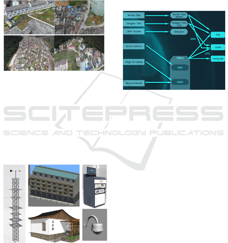
The real scene in the rural area shown in this paper is
collected by UAV in Chuntan Street, Anlong County,
Qianxinan Prefecture, Guizhou Province. Some of
the collected data are as follows.
Figure 2: Tilt photography data.
3.2 Establishment of Fine Model of
Important Facilities
Digital governance of rural environment is
inseparable from fine model. Based on 3DMAX
software, this paper carries out fine modeling of
important facilities in the area where sensors have
been installed. The content of fine modeling mainly
includes weather station, ecological breeding plant,
public toilet, garbage can, camera, etc., so as to
realize the fine modeling in the system by clicking on
the model (Fig. 3), The real-time monitoring data and
images of the facilities can be displayed intuitively.
Figure 3: Partial refinement model effect.
3.3 Format Conversion
The conversion interface is shown in figure 4 below.
According to the data format supported by the system
(Fig. 4), the format of Orthophoto data, terrain data
vector data, tilt data, artificial model data, point cloud
data, etc. is converted, and the converted data is
stored in the system database for viewing and
calling(Zhao 2021).
Figure 4: Cesium Lab supports common data format
conversion.
3.4 Using Cesium for Unreal to Import
Cesium for Unreal is a free plug-in on Unreal engine
Mall that installs and activates plug-ins. Use the
Cesium for Unreal plug-in to import the converted
oblique photography model and fine model into UE4.
3.5 Blueprint Interaction
Blueprints are a special class of asset that can be used
to create logic in an intuitive, node-based way, or to
set up some variable data. Planners can create custom
Actor, Event, functions, etc., and do Gameplay
iterations quickly without writing any code.
The blueprint can also choose to inherit the C++
class, get the variables defined in C++, call the
functions defined in C++, or implement the event
defined in C++. The interaction between scenes is
realized by using the blueprint function.
3.6 Use Pixel Streaming to Interact
with the Front-End Page
The implementation of pixel streaming is to put the
computing that can only run on the terminal in the
cloud, and call powerful high-end computing
resources (CPU/GPU/ memory, etc.) in the cloud to
Research on Digital Governance of Rural Environment Based on Cesium for Unreal
843

calculate. The end user uses a standard web browser
to connect to the application, of course, it can also
send a variety of control signals (mouse, keyboard,
touch, etc.) to the cloud computing node, and push
the calculated picture back to the terminal after
processing (Zhang, Zhou, Shen, et al. 2019). Pixel
streaming plug-in is integrated in UE4, and the
interaction between front-end Web interface and 3D
scene can be realized by using this plug-in. The effect
is shown in figure 5.
Figure 5: Front-end display interface.
3.7 Realization of Environmental
Governance Function
Through the collected sensor data and scene digital
information, based on the principle of Bryson
collaborative governance model, the environmental
governance function is developed, the factors of the
effectiveness of the target rural environmental
governance are extracted, and the governance
strategies are formulated through human-computer
interaction to provide the basis for environmental
governance (Zhou, LI, Wang, et al. 2018).
4 SUMMARY
This paper first studies cesium for unreal, and finds
that this technology combines the 3D geospatial
function of cesium with the high fidelity rendering
ability of virtual engine 4 (UE4). The combination of
cesium technology and virtual engine 4 technology
can realize the creation of 3D environment from real
to digital. Furthermore, based on the research of
digital construction of rural environment of cesium
for unreal, the digital and visual construction of rural
environment is realized, which provides a scientific
basis for environmental governance. If we want to
achieve more accurate environmental governance
function, we need to further improve the
environmental model.
ACKNOWLEDGMENTS
This paper is one of the phased achievements of the
project of China Electric Power Construction Co.,
Ltd. "Research on key Technologies of Integrated
Management and Control Service platform based on
5G Internet of things and Beidou Technology" (DJ-
ZDXM-2020-49).
This paper is one of the phased achievements of
the project of Guizhou Electric Power Design
Research Institute Co., Ltd., Power Construction
Corporation of China "Research on key
Technologies of Rural Digital Governance based on
Spatio-temporal big data" (GZEDKJ-2020-09).
This paper is one of the phased achievements of
the project of Guizhou Electric Power Design
Research Institute Co., Ltd., Power Construction
Corporation of China" Research on Spatial
Information Technology of Power Transmission and
Transformation based on Electric Power big data"
(GZEDKJ-2020-08).
This paper is one of the phased achievements of
the project of China Electric Power Construction Co.,
Ltd. "Power Grid Application based on Beidou
Satellite Navigation and data Analysis and Research
of ubiquitous Power Internet of things" (DJ-ZDXM-
2019-52).
The project of Guizhou Provincial Department of
Science and Technology "Beidou Satellite Power
Industry Application key Technology Research and
data Application industrialization" (2018) 3007.
REFERENCES
Association I, Maclennan B L, Bergeron S J. 3D Digital
City Platforms as Collaborative and Decision-Making
Tools for Small Municipalities and Rural Areas[M].
2014.
Du Pengfei. Design and implementation of 3D Virtual
Geographic Information system for Digital
Countryside [D]. Beihua Institute of Aerospace
Technology, 2021
Gao Chang. Research on the effectiveness of rural
environmental collaborative governance in county a
based on Bryson model [D]. Central China Normal
University, 2018
Hongcheng M A, Zhang Y, Liu W. Research and
Application of Wisdom Street 3D Visualization
Platform Based on the Open Source Cesium
ICPDI 2022 - International Conference on Public Management, Digital Economy and Internet Technology
844

Framework[J]. Geomatics & Spatial Information
Technology, 2019.
Jian Z. Digital Visualization of Design and Dwellings[C].
International Conference on Technologies for E-
Learning and Digital Entertainment. Springer, Cham,
2017.
Liu J, Liu H, Jing S, et al. Research on Effective
Organization and Scheduling of Massive 3D Building
Models for Constructing Digital Rural[J]. Sensor
Letters, 2012, 10(1):138-145.
Liuhao, Dai J, Liu Z. Computer Three-dimensional
reproduction technology of buildings in Digital City[J].
Microcomputer information, 2005(08):22-23.
Peng Xiang. Design and implementation of 3D
Visualization system of Wisdom Park based on
Cesium [J]. Electronic Design Engineering, 2021, 29
(08): 81-84.
Ren Min. Research on the present situation and path of
Digital Countryside Development based on
Internet+[J]. Light Industry Science and Technology,
2021, 37 (07): 124-125, 134.
Tian F. Immersive 5G Virtual Reality Visualization
Display System Based on Big-Data Digital City
Technology[J]. Mathematical Problems in Engineering,
2021, 2021(3):1-9.
Wang Mengru. Research on virtual modeling based on
Unreal Engine4 [J]. Information Technology and
Informatization, 2021 (04): 64-66.
Wang Yuheng, Li Dacheng, Zhang Dechao, Chen Jinyong,
Yang Yi, Yu Jie. Land cover data Visualization based
on Cesium [J] Radio Communication Technology,
2021 Magi 47 (03): 353,362.
Wu H, Zhong X, Zhao C, et al. Realization of the dynamic
interactive 3D virtual wandering system in the rural
community based on VRML[J]. Transactions of the
Chinese Society of Agricultural Engineering, 2008.
Wang Z, Li D, Fan T. A Research on key Vision
Technologies of Red Revolution site in Gannan Soviet
area based on UE4 Virtual engine platform[J]. E3S
Web of Conferences, 2020, 189(6):03001.
Ye X. The General Principles of the China's Rural
Vitalization Strategy in the New Era[J]. Reform, 2018.
Zhou L, Yan-Yan L I, Wang C H, et al. Development of
Industrial Integration and Sixth Industry in Rural
Vitalization Strategy[J]. Journal of Xinjiang Normal
University (Edition of Philosophy and Social Sciences),
2018.
Zhao Weiming. Research on the Application of Real-time
Ray tracing Technology based on UE4 in display
Design [J]. Electronic Test, 2021 (06): 43-45.
Zhang X, Zhou W, Shen J, et al. 3D Interactive
Visualization Method of Urban Waterlogging Based
on Cesium[C].29th International Cartographic
Conference. 2019.
Zhang Q, Cheng W, Shi Z C, et al. A three dimensional
modeling and simulation platform design for digital
city[J]. Proc Spie, 2006, 6(3):59855S-59855S-8.
Research on Digital Governance of Rural Environment Based on Cesium for Unreal
845
