
Model Analysis of River Watershed Development Based on Local
Wisdom (Case Study Banjar Sala Area, Bangli)
Kadek Adi Suryawan, I Gusti Lanang Made Parwita, Nyoman Anom PW, Made Mudhina
and Ketut Wiwin Andayani
Department of Civil vil Engineering Bali Sate Polytechnic, South Kuta, Bali, Indonesia
Keywords: River Management, Local Wisdom, Embedding.
Abstract: From ancient times until now rivers have been used for human activities such as agriculture, plantations,
fisheries and animal husbandry, clean water, water traffic, and so on. The Sangsang River originates in Bangli
Regency, flows south in the Gianyar Regency area. On the river section located in Banjar Sala, Abuan Village,
Bangli Regency, has been utilized for self-purification activities that combine activities on the river section
with activities on the springs next to the river. Some areas are located in river bodies, but structurally they do
not disturb the river morphology. This area is managed by the Banjar Sala Traditional Village by involving
all elements such as youth, religious leaders, and traditional leaders. From the field analysis it is known that
the Sala river has a width of 5 m, a channel height of 3 m, and a channel bottom slope of 0.03. From the
analysis of the capacity of the river, the capacity of the river at the point in front of the embedding area is
91.38 m3/s. This capacity is still greater than the flood discharge that occurs with a return period of 25 years
of 78.39 m3/second. Economic studies show that this area can improve people's welfare.
1 INTRODUCTION
The river and the surrounding community have a very
close relationship and provide very positive things for
life. Communities around the river have local wisdom
which is a way to protect the sustainability of the river
area (Sumarmi 2015), (Ferry 2019), (As’Ari et al.
2019).
The purification place of Banjar Sala, which is
located in Banjar Sala, Abuan Village, Susut District,
Bangli Regency is one of the vaporite places for
residents around Bangli and other areas in Bali to
carry out self-cleaning/purification activities. Banjar
Sala is located on the east side of the Sangsang river
which flows from the northern area around
Kintamani. In this section the river has the
characteristics of a volcanic river with the walls
mostly in the form of volcanic rocks. The width of the
river varies widely between 2-15 meters with a very
steep slope and a terraced riverbed. This geographical
condition provides its own charm and challenge for
visitors. The embracing place itself is divided into
three areas, namely the Pancoran Dedari area, the
North Pancoran area and the Sala Park area whose
water comes from springs. This unique place is one
of the attractions for visitors to come to this place
which on holidays even reaches hundreds of people
per day.
To support the comfort for visitors, this area has
been arranged by constructing several buildings as
supporting facilities such as changing rooms, toilets,
structuring the Pancoran Dedari area, building a
connecting bridge in North Pancoran, structuring
river channels and structuring the main landing site in
the form of construction. statues and ponds for
embracing are equipped with areas for prayer. All
these activities are coordinated with the community
(banjar) management and are fully supported by
residents living around the area. The more familiar
this place is, the more people visit it, especially on
holidays such as Saturdays and Sundays. The arrival
of visitors has an impact on improving the welfare of
the surrounding community through donations given
and the opportunity to sell for the surrounding
community on a small scale.
The very rapid development in this area has not
been followed by in-depth studies related to technical
and socio-cultural aspects such as aspects of safety
against flooding in the area, as well as in-depth
planning related to local wisdom-based river
management which is associated with the concept of
622
Suryawan, K., Parwita, I., Pw, N., Mudhina, M. and Andayani, K.
Model Analysis of River Watershed Development Based on Local Wisdom (Case Study Banjar Sala Area, Bangli).
DOI: 10.5220/0011857800003575
In Proceedings of the 5th International Conference on Applied Science and Technology on Engineering Science (iCAST-ES 2022), pages 622-629
ISBN: 978-989-758-619-4; ISSN: 2975-8246
Copyright © 2023 by SCITEPRESS – Science and Technology Publications, Lda. Under CC license (CC BY-NC-ND 4.0)

one river one management which carries the system.
sustainable river management in various aspects, both
elements of the government, the community around
the river and the community of visitors who come to
this area. For this reason, it is necessary to carry out
technical studies in the form of hydrology and
hydraulics related to flooding as well as socio-cultural
and environmental analysis related to community
participation in river management. The current
problems are how is the current condition of the
Banjar Sala area, how is the technical study related to
flood conditions that can occur in this area, how is the
socio-cultural and environmental study of river
management based on local wisdom to support
sustainable river management?
2 METHOD
2.1 Research Approach
In this study, the research is based on quantitative
analysis based on the results of direct observations
and measurements in the field, secondary data
collection from relevant agencies in this case the Bali
Penida River Council and the Bangli Regency Public
Works Office, conducted interviews with the Banjar
Sala management group and village officials and
community, conduct analysis and provide
recommendations.
2.2 Analysis Method
The analysis used in this study includes hydrological
analysis for determination of rain using the Gumbel
and Log Perason type III methods, Nakayasu method
for design flood analysis and Manning analysis for
hydraulic analysis and river capacity. Socio-cultural
analysis was carried out by quantitative statistical
analysis of the respondents' answers (Sholihah et al.
2020), (Kwarteng, Dorvlo, and Kumar 2009),
(Tessema 2011)
2.3 Data Collection Method
The data collection method is carried out by
collecting secondary and primary data in the
following ways:
Secondary data
a. From the Bali River Council and the Public work
Office of Bangli Regency in the form of:
1. Sangsang river morphological data (River
length, watershed area, vegetation etc.)
2. River development policy data
b. Meteorology, Climatology and Geophysics
Agency (BMKG) Region III Bali in the form of
annual maximum daily rainfall data
c. Banjar Management data is in the form of existing
data for banjar Sala management in the form of:
administrators, membership, maintenance systems,
development systems, cooperation systems etc.
2.4 Surveys, Field Observations,
Preliminary Research
1. Survey
Observations were made on the embedding building
which is located on the edge of Sangsang river which
is directly connected to the river. Observations made
include:
a. Location of the Banjar Sala building
b. The physical condition of the Banjar Sala building
c. Organizational and governance systems
d. Cross-sectional survey of rivers and stream
systems
2 Field Observations
Most of the field observations focused on the work
pattern of Banjar Sala from the initiation of
development, governance and institutions. In this
activity the most widely used method is the interview
method with several elements such as managers,
community leaders, surrounding communities,
elements of the local Village Government and the
Bangli Regency Government.
3. Preliminary Observation
Preliminary observation was carried out one month
ago for 1 day to obtain an overview of the location
and current conditions. From the observations made,
it shows that from a technical point of view, the
Banjar Sala building is in direct contact with the
riverbank so that it is vulnerable to flood hazards.
From the socio-cultural and environmental point of
view, visits on holidays are quite hectic with visits
ranging from 50-100 people per day. There is no
quotation for the visitors, but a donation box is
opened if the visitors are willing to donate some of
their money to repair the needed facilities. It is
necessary to test the quality of the water at the trap
because the water is drunk by the visitors. The current
Model Analysis of River Watershed Development Based on Local Wisdom (Case Study Banjar Sala Area, Bangli)
623
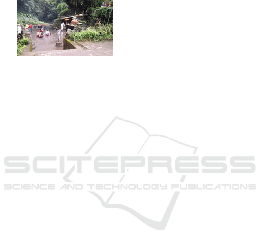
conditions in the Banjar Sala are as shown in the
Figure 1:
Figure 1: Condition of the Sala Banjar Sala.
3 RESULTS AND DISCUSSION
3.1 The Balinese Hindu Community's
View on Water
For the Hindu community in Bali, water is the first
and foremost gift for humans because water is the
source of human life. In the traditional rituals of the
Hindu community in Bali, it can be stated that there
is no ritual that does not use water as a means of
ceremony. Starting from the beginning of life to the
death ceremony, water becomes one of the means to
the afterlife. The water facility that takes people who
have died to another world is called Tirta Penatas.
Tirta Penatas is taken in a spring, river or even the
mouth of a river accompanied by sacred prayers from
the family of the person who has died. Then Tirta
Penatas is sprinkled on people who have died before
being buried or burned (Wirawan and Pendit 2017).
For the Hindu community in Bali, the three powers of
the manifestation of God Almighty are called Dewa
Vishnu (God = holy light from God) who have a role
in regulating world life, one of which is by regulating
water resources. In the Balinese Hidu concept, water
is one of the elements that make up humans (buana
alit) and the universe (buana Agung), namely pertiwi
(land), apah (water), teja (heat), bayu (energy) and
akasa (ether / marrow). With such a large role of
water in human life, maintaining and conserving
water is an effort to preserve life and life (Suarya,
Paramadhyaksa, and Suryada 2018), (Fuady and
Azizah 2008).
3.2 Ritual of Self-Cleansing with Water
(Self-Purification with Water)
Self-purification with water is an activity of self-
purification either with fresh water (in rivers/springs)
or with sea water. In general, the meaning of self-
purification with water is to clean oneself and clean
the mind so that the inner and outer atmosphere
becomes fresher and healthier. With a healthier body
and soul, it has a very positive effect on productivity
in living daily life. The current development in Bali
is that the self-purification with water ritual is one of
the activities carried out by many community groups
or families which is usually carried out on certain
days such as during the full moon, dead moon (tilem),
and other holy days or on holidays. namely Saturday
or Sunday (Sudiarta 2021), (Mahardika 2018). At the
time of self-purification with water, the facilities
brought by each participant were offerings (banten) in
the form of banten pejati and canang sari which were
presented to several place. Banten were presented
with prayers asking for God's grace, the self-
purification with water process could run smoothly
and the people who self-purification with water
would be given health.
3.3 Abuan Village Overview
Abuan Village is one of the villages in the Susut
District, Bangli Regency with an area of 4.18 km2
with a population in 2021 of 7,490 people with a total
area covering 5 Banjar Dinas namely: Banjar Dinas
Abuan Kangin, Banjar Dinas Abuan Kauh, Banjar
Dinas Preparation Serokadan Kaja, Banjar Dinas Sala
and Banjar Dinas Serokadan. Meanwhile, the village
boundaries include: North: Susut Village, East:
Demulih Village, South: Abuan Village and West :
Petak Village, Gianyar Regency.
The population of Abuan Village is spread over 5
hamlets with a male population of 3,716 and a female
population of 3,774. Judging from the age distribution
of the population, Abuan village is in the dominant
composition in the productive age, namely at the age
of 50-54 years with a percentage of 33.9%.
Judging
from the education status of its citizens, most of the
dominant population graduated from elementary
school/equivalent, followed by junior high school
graduates/equivalent. Judging from the main
livelihood of the residents of Abuan Village, most of
them work as farmers/planters, followed by students,
private employees. associated with the Village
Development Index (IDM) there are several criteria
that must be met from several indicators, namely the
health sector, the education sector, the
implementation of mutual cooperation, public
facilities, sports, religion, security, information and
telecommunications facilities, solid waste, clean
water, the economy and handling disaster. Based on
the 2021 assessment of the facilities and
infrastructure index (IKS) with a score of 0.82, the
iCAST-ES 2022 - International Conference on Applied Science and Technology on Engineering Science
624

economic index of 0.58 and the environmental index
of 0.93. Based on the index value, the IDM of Abuan
village is 0.78 which is classified as a developed
village.
3.4 Banjar Sala Temple
Banjar Sala Temple is one of the self-purification
with water places located on the banks of the
Sangsang tributary located in Banjar Sala, Abuan
Village, Susut District, Bangli Regency. This self-
purification with water place is located about 4.5 km
west of Bangli City or about 40 km northeast of
Denpasar city. Geographical location at 8
o
45”13.95”
latitude ,115
o
32'46”45 east longitude. The history of
the establishment of the Pecampuhan Sala self-
purification with water place began with the desire of
several community leaders in this area to create a
representative purgation place whose location allows
it to be built on the west side of Temple which is
directly adjacent to the Sangsang river tributary. The
wishes of several community leaders are fully
supported by the community and village leaders as
well as by the youth. As a first step, the construction
of a embracing place was started, which contained
two pool, several statues and a courtyard for praying.
For the purposes of this development, the community
independently raised an initial fund of Rp. 380
million rupiah. In 2017 initial construction began
with the construction of a pond and several sculpture
ornaments including the Shiva Statue, Nandini Ox
Statue and other decorative statues made in the
northeast. Each shower has also been equipped with
a statue of an angel lined up in the main pool. To
separate the embracing pool from the prayer area, a
gate has been made in the form of the Kurung Temple
gate made of red brick facing the south. Banjar Sala
is also synergized with the preservation of the
surrounding river area with a procession of embracing
that takes place on the river body, namely at the
Pancoran Dedari waterfall and at the Gua Tan Hana
waterfall. The name Pecampuhan is taken from the
name of the confluence of two tributaries (campuhan)
in that location. While Sala is taken from the name of
the banjar where the spring is located. At this time,
there has been a parking park located to the south that
can accommodate 25 minibus cars and several
motorcycles. From the parking lot to the landing
place, walk along the village road which is paved for
about 75 m with a width of 5 m, followed by
descending stairs made of concrete with a length of
about 200 m. All the way to the hug has been planted
with trees that blend with the surrounding
environment. Likewise, the road along the stairs to
the hug is very clean and comfortable. For activities
at night, it has been equipped with lighting facilities
in the form of electricity. The scenery around the
embrace of natural mountain conditions with tropical
plants. The meandering river and steep walls make
the natural conditions even more pronounced. For the
self-purification with water place, this place is located
just below Taman Temple, there are 9 showers,
divided into two separate places. The first part at the
very top has 7 showers, with the height of the shower
reaching 3 meters in this place a 1-meter-high water
reservoir is made. Then 2 pancorans are located at the
bottom on the riverbank. Apart from the holy water
that flows from the 9 showers, the other place of
embracing is in the river which is the meeting place
for the flow of two rivers (campuhan). The two
sources of river flow are called Grojogan Pesiraman
Tan Hana for the right side of the river and Grojogan
Pesiraman Dedari for the left side of the flow. For the
flow of the river to the right there is another shower
for self-purification with water. The water that flows
in each of these rivers is very clear, thus adding to the
coolness of the heart and mind for those who want to
self-purification with water. Information about
Taman Pecampuhan Sala Temple is believed to have
good fortune and benefits such as Tirta Pule for
treatment, Tirta Pandan for repellent Bala, Tirta
Bungbung for economic smoothness and Tirta Tulak
Wali for family harmony, strengthening husband and
wife relationships so that they last.
3.5 Concept of Community-Based
River Management (Local
Wisdom)
The river management model in Banjar Sala Taman
Sala applies the concept of balanced river
management referring to the Balinese cultural
philosophy, namely Tri Hita Karana (harmonious
relationship with God, between human beings and
with the surrounding environment). Some important
concepts from the Banjar Sala Taman Sala
management system with the concept of a sustainable
river are as follows:
1. The building that is made is not in the middle of
the river so that morphologically the flow of the
river is not disturbed
2. The minimum building height has taken into
account the height of the flood water so that the
influence of scouring and puddles during floods
can be reduced
3. Arrangement of the river into a place of
embedding does not change the original shape of
Model Analysis of River Watershed Development Based on Local Wisdom (Case Study Banjar Sala Area, Bangli)
625

the river such as the walls and width and material
around the river
4. There are guides who are very helpful in
explaining the local wisdom of the local
community towards the existence of rivers and
their environment
5. Any additional decorative ornaments that are
complementary to the place of attachment are
discussed at the management coordination
meeting which is fully supported by the villagers
6. There was a very high independent effort from the
local community at the time of the initial
construction of the self-purification with water
place
7. There is full involvement of citizens both as
managers, stakeholders and as guides
8. The added value of this self-purification with
water place does not charge entrance fees, but the
concept is in the form of donations from visitors.
9. Maintenance of the embracing area is carried out
jointly by all levels of society
3.6 Hydrological Analysis
Hydrological analysis was carried out to determine
the design rain and design floods which were used as
the basis for analysing river capacity (Burgan and
Icaga 2019), (Yihdego, Reta, and Becht 2016),
(Tessema 2011). This analysis is especially necessary
to find out whether the cross section of the river in
front of the Pura Banjar Sala Taman Sala is still able
to accommodate the existing water at the time of the
flood. flood design and river capacity analysis.
3.6.1 Rain Station Analysis
This analysis is carried out to determine which rain
stations are around the location and the range of
recording rain data for how many years. In this
analysis, a search was carried out on rain data owned
by the Meteorology, Climatology and Geophysics
Agency (BMKG) and rain stations owned by the Bali
Penida River Council. From the analysis carried out,
the rain stations used are the Ubud rain station in the
west, the Gianyar rain station in the south and the
shrinkage rain station in the north. Figure 2 shows the
position of the rain station. Double mass test method
shown Figure 3-5
Figure 2: Rain station in Sala.
Figure 3: Ubud station double mass test.
Figure 4: Susut station double mass test.
Figure 5: Gianyar station double mass test.
3.6.2 Design Rain
Recapitulation of Design Rainfall Analysis with
various return periods. The details can be seen in
Table 1.
iCAST-ES 2022 - International Conference on Applied Science and Technology on Engineering Science
626
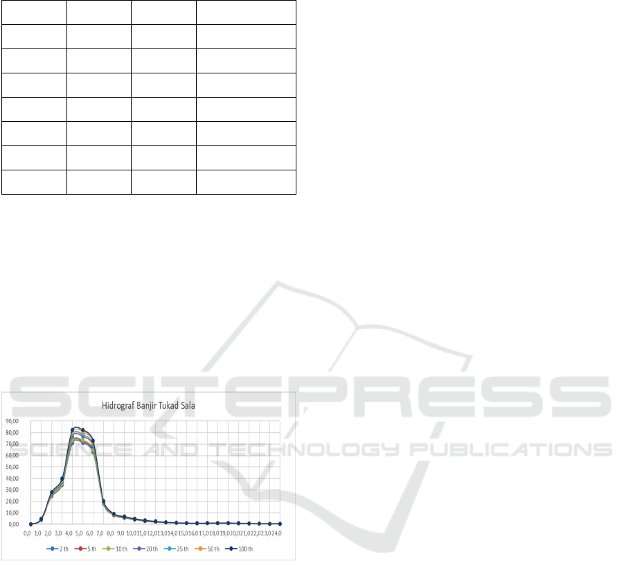
Table 1: Recapitulation of Design Rain with Various
Repeat Periods.
No Period G Extravolation
1 2 0.63 97.21
2 5 0.97 99.13
3 10 1.12 100.2
4 20 1.11 105.23
5 25 1.11 107.34
6 50 0.96 110.72
7 100 0.82 112.54
3.6.3 Design Flood
Design flood analysis was carried out to determine
the magnitude of the flooding that occurred in an area
by entering several parameters such as the design
rainfall value, the length of the main river, the area of
the watershed and others (Harahap, Jeumpa, and
Hadibroto 2018), (Marhendi and Fathurohman 2020).
The design flood was calculated by the Nakayasu
method. The results of the design flood calculations
can be presented in Figure 6 below:
Figure 6: Flood Hydrograph of the Sala River.
3.6.4 Capacity Analysis
From the field analysis, it was found that Sala River
has a data width of 5 m, a channel height of 3 m and
a channel bottom slope of 0.03. From the analysis of
river capacity, the river capacity at the point in front
of the embedding area is 91.38 m3/sec. This capacity
is still greater than the flood discharge that occurred
with a 25-year return period of 78.39 m3/sec. With a
river width of 5 m and a dam in front of the catchment
area, if there is a flood discharge with a return period
of more than 25 years, it has the potential to cause
flooding and puddles.
3.7 Community Based River
Management
The development of the self-purification with water
place at Banjar Sala has various effects on the
surrounding community, on the river and on Taman
Temple itself. Based on interviews with community
leaders, managers, the community around the temple
and followed by interviews with visitors, an analysis
of the community-based river management system
was carried out. The results of the analysis are shown
in the following sections:
Technical Overview
Technically Banjar Sala Taman Sala is located on the
edge of a tributary of the Sangsang river with a river
wall in the form of rock. The river flows in the dry
season with a height of about 0.5-0.6 m. During the
rainy season the water level can reach a height of 2 m.
Strength
1. The results of the hydrological analysis show
that the capacity of the river in front of Banjar Sala is
still able to accommodate flood discharges with a
return period of 265 years, so that morphologically
the river does not erode existing buildings.
2. The high slope of the river has an impact on high
water velocity thereby reducing the potential for
inundation in front of the embedding area
3. Sturdy River walls have a positive impact on
overall river stability.
Weakness
1. With a typical mountain river, when it rains it
carries a lot of sediment which causes the
watercolour to be cloudy and dangerous for
visitors
2. There is still a lack of lighting/electricity facilities
at night
Follow-up
1. It is necessary to install dangerous signs/signs at
several points as a guide for visitors
2. It is necessary to preserve the forest in the
upstream area to prevent sedimentation that can
occur during the rainy season
3. Need additional lighting/electricity facilities in
several places at night
Economic Review
Economically Banjar Sala at Pura Pecampuhan
Taman Sala provides benefits for improving the
community's economy even though it is still on a
small scale.
Strength
Model Analysis of River Watershed Development Based on Local Wisdom (Case Study Banjar Sala Area, Bangli)
627

1. From the existing conditions in the field, the
community can start to open a business selling
several types of food such as fried bananas,
traditional Balinese snacks such as lempog, laklak
and jaja injin, snack chips such as taro chips, glass
noodles, coffee and various drinks and one of
them is traditional drinks. Loloh (herbal
medicine) made from cem-cem leaves that are
widely available around the area. This drink is a
typical drink of the Bangli people. Besides that,
there are people who sell prayer facilities such as
incense, water containers, canang etc.
2. The income from parking fees for each 4-wheeled
vehicle is Rp. 5000 and 2 wheels for Rp. 2000.
This levy provides income for traditional villages
3. There are donations from the community who
carry out the hug
Weakness
The sales system is still a very simple shop and looks
untidy. The roof of the shop is still made of tarpaulin,
reducing the interest of buyers. The sellers do not
provide adequate places to sit and rest after self-
purification with water so that buyers rarely shop for
a long time.
Follow-up
Need to arrange the food sales area with a neater
environment and buildings
Socio-Cultural Overview
Strength
1. This place is a favourite place in southern Bali as
a self-purification with water place. Of course,
this has an impact on the success of traditional
villages in managing their potential wisely and
sustainably
2. Activities at Banjar Sala received positive support
from the entire community, starting from
traditional leaders, youth and other communities
3. Starting to grow awareness of maintaining the
cleanliness of the surrounding environment so
that this place is always kept clean
4. The existence of traditional regulations that
supports the existence of Banjar Sala Taman Sala
so that it has a very positive impact on the
preservation of the area
Weakness
1. The number of visitors who come if excessive and
the time is late at night has the potential to pose a
danger when carrying out the ritual of embracing
2. The small parking area has the potential to spill
over into the residential streets and disturb the
residents' comfort
Follow-up
Need arrangements for visitors, especially during
holidays to avoid the accumulation of visitors until
late at night
4 CONCLUSION
Based on the results of the analysis that has been
done, it can be concluded several things as follows:
1. Conditions Banjar Sala is located on the edge of
the Sangsang river tributary. The structure of the
building is a place for self-purification with water
with stone masonry construction. Conditions nself
purification with water Pancoran Dedari and Tan
Hana Caves are located on the river body with the
condition of the building in the form of a natural
river. The river flows meandering with the
riverbed in the form of rock. The lighting
conditions are still limited so that it is dangerous
for visitors if the activities are carried out until the
evening.
2. From the field analysis, it was found that Sala
River has a data width of 5 m, a channel height of
3 m and a channel bottom slope of 0.03. From the
analysis of river capacity, the river capacity at the
point in front of the embedding area is 91.38
m3/sec. This capacity is still greater than the flood
discharge that occurred with a 25-year return
period of 78.39 m3/sec. With a river width of 5 m
and a dam in front of the catchment area, if there
is a flood discharge with a return period of more
than 25 years, it has the potential to cause flooding
and puddles.
3. Socio-cultural and environmental studies show
that the existence of Banjar Sala has the following
impacts:
Economic aspect: increasing community
participation in the small-scale economy through the
sale of traditional food-based foods. Increase village
income through parking fees and donations from
visitors.
Socio-cultural aspects: the socio-cultural analysis
shows that the existence of this Banjar Sala has
received support from various groups such as
community leaders, community youth and
government institutions. The existence of trust from
the water community as a source of life and welfare
has an impact on sustainable and wise river
management through community values and
regulations (customary village law).
iCAST-ES 2022 - International Conference on Applied Science and Technology on Engineering Science
628

Environmental aspects: the maintenance of trees
and tree diversity and the situation of the waters
around the banjar sale area.
ACKNOWLEDGEMENT
Thank you to all those who have helped with this
research, especially from the Bangli Regency Public
Works Department and the managers
REFERENCES
As’Ari, R. et al. 2019. “Management of Water Resource
Based on Local Wisdom: A Develompment Study of
Kampung Naga as Field Laboratory of Geography
Education in Tasikmalaya, West Java.” IOP
Conference Series: Earth and Environmental Science
243(1).
Burgan, Halil Ibrahim, and Yilmaz Icaga. 2019. “Flood
Analysis Using Adaptive Hydraulics (ADH) Model in
the Akarcay Basin.” Teknik Dergi/Technical Journal of
Turkish Chamber of Civil Engineers 30(2): 9029–51.
Ferry, Dharma. 2019. “Local Wisdom Based Water
Resources Conservation for Environmental
Sustainability.” Scientiae Educatia 8(2): 220.
Fuady, Zahrul, and Cut Azizah. 2008. “Tinjauan Daerah
Aliran Sungai Sebagai Sistem Ekologi Dan Manajemen
Daerah Aliran Sungai.” Lentera 6: 1–10.
Harahap, Rumilla, Kemala Jeumpa, and Bambang
Hadibroto. 2018. “Flood Discharge Analysis with
Nakayasu Method Using Combination of HEC-RAS
Method on Deli River in Medan City.” Journal of
Physics: Conference Series 970(1): 0–11.
Kwarteng, Andy Y., Atsu S. Dorvlo, and Ganiga T.Vijaya
Kumar. 2009. “Analysis of a 27-Year Rainfall Data
(1977-2003) in the Sultanate of Oman.” International
Journal of Climatology 29(4): 605–17.
Mahardika, Nyoman. 2018. “Esensi Ritual Self purification
with water Sebagai Daya Tarik Wisata Spiritual.”
Pariwisata Budaya: Jurnal Ilmiah Agama Dan Budaya
3(2): 51.
Marhendi, Teguh, and Fathurohman. 2020. “Analysis of
Flood Discharges of Serayu River at Serayu Barrage
Using HSS Gama i and Nakayasu Models.” IOP
Conference Series: Materials Science and Engineering
771(1).
Sholihah, Qomariyatus et al. 2020. “The Analysis of the
Causes of Flood Disasters and Their Impacts in the
Perspective of Environmental Law.” IOP Conference
Series: Earth and Environmental Science 437(1).
Suarya, I Made, I Nyoman Widya Paramadhyaksa, and I
Gusti Agung Bagus Suryada. 2018. “Konservasi Pura
Tirta Bulan Di Desa Singapadu Tengah, Gianyar:
Penataan Objek Bersejarah Berbasis Prinsip Ekowisata-
Spiritual.” : A001–8.
Sudiarta, I Wayan. 2021. “Konsep Tri Hita Karana Dalam
Pelaksanaan Pariwisata Budaya Hindu.” Jurnal Ilmiah
Pariwisata Budaya Hindu 2(1): 12–23.
Sumarmi, Sumarmi. 2015. “Local Wisdom of Osing People
in Conserving Water Resources.” KOMUNITAS:
International Journal of Indonesian Society and
Culture 7(1): 43–51.
Tessema, Selome M. 2011. Trita-LWR. LIC NV - 2056
Hydrological Modeling as a Tool for Sustainable Water
Resources Management: A Case Study of the Awash
River Basin. http://kth.diva-portal.org/smash/
get/diva2:416594/FULLTEXT01.pdf%0Ahttp://urn.kb
.se/resolve?urn=urn:nbn:se:kth:diva-33617.
Wirawan, I Gst Ngurah Putu Dedy, and I Made Raharja
Pendit. 2017. “Penerapan Tri Hita Karana Dalam
Harmonisasi Konservasi Dan Budaya Di Daya Tarik
Wisata Kebun Raya Bali.” Jurnal Master Pariwisata
(JUMPA) 4: 18–32.
Yihdego, Yohannes, Gebrehiwet Reta, and Robert Becht.
2016. “Hydrological Analysis as a Technical Tool to
Support Strategic and Economic Development: A Case
Study of Lake Navaisha, Kenya.” Water and
Environment Journal 30(1–2): 40–48.
Model Analysis of River Watershed Development Based on Local Wisdom (Case Study Banjar Sala Area, Bangli)
629
