
Degradation of Grassland Covered by Coal Dust in a Temperate
Steppe
Wang Jian
1,2,† a
, Qu Zhi-Qiang
3,† b
, Wang Zhan-Yi
3c
and Hou Jia
4,* d
1
Research Institute of Highway MOT, Beijing, China
2
Key Laboratory of Road Traffic Environmental Protection Technology, MOT, Beijing, China
3
College of Grassland, Resource and Environment, Inner Mongolia Agricultural University, Hohhot, China
4
Vocational and Technical College of Inner Mongolia Agricultural University, Baotou, China
Keywords: Coal Mine, Soil Organic Carbon, Grassland Health, Lignite Dust, Plant Community Features, Carbon Isotopes.
Abstract: The exploitation of open pit mines in grassland brought many environmental problems. In this study, two
sizeable open-pit lignite mines in Inner Mongolia grassland were selected for study. We investigated the
vegetation and soil status of grasslands surrounding the coal mines. By comparing grasslands covered with
coal dust (GD) to the adjacent normal grasslands (CK), we found that the vegetation coverage, grass yield,
soil organic carbon, and soil nitrogen content of GD grasslands were lower than those that in the CK
grasslands. Based on the Chinese grassland degradation standards, we made an evaluation and found that
there was moderate-severe degradation of grassland around the mines after seven years of mining. We can
conclude that the exploitation of lignite mines caused the degradation of surrounding grasslands, and we
should pay attention to the controlling of pollutants emission and protecting the natural grassland.
1 INTRODUCTION
With the development of industrialization and the
increment of the world's population, human demand
for fossil fuels is increasing. Coal plays an important
role in supporting global energy consumption and
economic development (Bhattacharya et al., 2015).
China is one of the top five coal mining countries in
the world, including China, the United States, India,
Indonesia, and Australia (World Coal Association,
2014). About 90% of China's coal resources are
distributed in northern China (China geology survey,
2016), where most of land is grassland. About 41% of
China's land surface is natural grassland, which plays
a vital role in the economic development of pastoral
areas and in improving people's living (Sun, 2000). It
is an important issue that rational management and
protection of grassland resources to achieve regional
eco-economic-social sustainable development in the
a
https://orcid.org/0000-0002-2097-9987
b
https://orcid.org/0000-0003-0454-514X
c
https://orcid.org/0000-0002-9690-878X
d
https://orcid.org/0000-0002-3339-3934
†
These authors contributed equally to this article.
*Corresponding author
world. Besides boostting the economic and social
development of the region, the exploitation of coal
resources may also cause many potential ecological
and environmental problems, which includs pollution
of the surrounding areas of the mining area―air
pollution, water pollution, soil erosion, and
desertification, leading to ecosystem degradation,
changes of fauna and flora, loss of biodiversity,
damage to landscapes (Ejaz et al., 2014; Si et al.,
2010). The causes of such pollution are mainly the
emission of gaseous pollutants and the disturbance of
groundwater and surface drainage. Dust and gaseous
pollutants are more serious pollutants in arid areas.
The areas affected by these pollutants are mainly the
mining operation area in the mining area and the
surrounding area of the mining area.
The atmospheric pollutants produced by coal mining
impact on individual plants and plant populations. For
the plant leaves, the air around the coal mine often
52
Jian, W., Zhi-Qiang, Q., Zhan-Yi, W. and Jia, H.
Degradation of Grassland Covered by Coal Dust in a Temperate Steppe.
DOI: 10.5220/0011900300003536
In Proceedings of the 3rd International Symposium on Water, Ecology and Environment (ISWEE 2022), pages 52-60
ISBN: 978-989-758-639-2; ISSN: 2975-9439
Copyright
c
2023 by SCITEPRESS – Science and Technology Publications, Lda. Under CC license (CC BY-NC-ND 4.0)

contains sulfur dioxide (SO
2
), nitrogen dioxide (NO
2
),
and total suspended particulates (TSP) (Pandey et al.,
2014). These substances would inhibit the plant
growth. The dust deposition would decrease the
stomata conductance of the plant leaves and affect on
respiration and photosynthesis. Coal dust reduced the
CO
2
gas exchange and photosynthesis efficiency of
African mangrove leaves (Naidoo and Chirkoot,
2004). Coal powder addition can also inhibit the root
growth of forages (Wang et al., 2016). As the
development of individual plants is affected by coal
mine pollutants, it will further affect the competition
between populations and species, leading to changes
in community structure (Pandey et al., 2014).
Exploration of coal mining would reduce the number
of plant species in contaminated areas, thereby
reducing biodiversity (Spencer and Tinnin, 1997).
Coal dust can change the dominant trees in wetlands
by modifying the succession of plant communities
(Naidoo and Chirkoot, 2004). There is a general
perception that dust accumulation on plant surfaces
causes negative impacts on plants. While after five
years of observation, it was found that there was no
significant correlation between the emissions of inert
dust sourced from the Australian mines and the
growth of the Tetratheca paynterae or the
composition of the flora (Matsuki et al., 2016).
Because the amount of natural dust in the arid area
has been relatively large historically, the plant has
specific adaptability. As a dry area, the plant of Inner
Mongolia grassland is often disturbed by dust. The
open-pit mines of the grassland also would produce a
large amount of dust during the mining process. How
this coal dust depositions affect the grassland is one
of the scientific problems of this study.
Most of large open-pit coal mines in China are
distributed in an arid and semi-arid area with
vulnerable environments. Among them, four of the
five larger open-pit mines in China distributed in
Inner Mongolia grassland (Ratcliffe, 1974; Bai et al.,
2006). From 2006 to 2010, coal production of Inner
Mongolia was the biggest in China (Liao and Wei,
2011). Eleven out of the 14 open-pit coal mines in
China are found in Inner Mongolia grasslands (Geng,
2008; Ma et al., 2006). Thus, dust pollution may
affect the livelihood of local herders via its damage to
rangeland health. The production of lignite was
biggest in the typical steppe of Inner Mongolia. The
addition of humic acid extracted from lignite is
beneficial to improve soil fertility and promote plant
growth (Tahir et al., 2011). Then, after the lignite dust
deposition on grassland around the coal mine, how
does the grass growth, soil, and grassland health
change? We hypothesize that the deposition of lignite
dust will hurt the development of grass, especially in
arid regions where is a lack of rainwater to wash the
dust on the leaves. To certify our hypothesis, we
selected two open-pit coal mines in the typical steppe
of Inner Mongolia as the research object and
evaluated by comparing the health of adjacent
grasslands around the mining area.
2 MATERIALS AND METHODS
2.1 Study Area and Sampling Design
Two large coal mines in this study situated in
Xilinhot, Inner Mongolia. The mean annual
temperature is –0.4 ℃ with extremes ranging from –
27.0 to 28.6 ℃ (Xiao, 1997). The long-term mean
annual precipitation is 360 mm and varies from 180
to 500 mm. The prevailing winds of the two mining
areas are western wind, and the soil types are
kastanozems (FAO, 1991). The coal types are brown
coal. In this study, the vegetation and soil survey of
W3 mine was completed in 2014, and the data survey
of B3 mine was completed in 2016.
Case 1: Shengli Coalfield West No. 3 Open-pit Coal
Mine (W3) is situated in Shengli Town, about 3km
north of Xilinhot City. The geographical location is
between 43°58'10.0" N, 43°58'52.8"N and 115°
57'03.8"E, 116 °00'20.8"E (Fig. 1-a). The coal mine
was established in 2007, with an annual output of
about 600 million tons (Beijing Huayu Engineering
co., 2015). The area is 2.47 square kilometers. The
coal quality is medium ash, medium sulfur, and low
phosphorus lignite (Feng et al., 2005). The study area
is set in downwind of the mining area and was fenced
and used as an area for high-voltage transmission
lines. Based on the surface dust coverage, two areas
were selected as the control area (CK) with almost no
dust cover and the dust great deposition area (GD),
respectively. The GD area was generally covered the
black coal dust, while the CK area had almost no coal
dust on the ground. The GD area is 100 meters from
the edge of the pit. The CK areas located at the
neighboring side of the GD areas within 1km. The
sample plot is rectangular with an area of 10 m×10 m.
There are three sample plots in both CK and GD area.
There are four quadrats in each plot with an area of 1
m2.
Case 2: Baiyinhua No. 3 Mine (B3) is situated in
Baiyinhua Town, Xiwuzhumu County, Xilinhot City.
It is located between 44°56'03.7"N, 44°51'42.3"N
and 118°31'40.5" E, 118°37'39.0"E (Fig.1-b). The
mine was established in 2006. Lignite of Baiyinhua
Degradation of Grassland Covered by Coal Dust in a Temperate Steppe
53

coalfield is high-quality, medium-ash, low-sulfur
content. The designed production capacity is 1.4
million t/a. The terrain of the study area is gentle.
There is no river around the mining area. The annual
average precipitation of Baiyinhua Town is 345.9 mm,
and the annual evaporation is 1769.0 mm. The annual
rainy season is June, July and August, accounting for
68% of the annual precipitation. The soil type is
chestnut soil.
The study area is set in downwind of the mining area,
which was fenced and used as a mowing grassland.
The grass was harvested in September once a year.
The GD area is 100 meters away from the edge of the
pit. The CK area is set on the east of the contaminated
area 1km. The sampling method is the same as that
for the W3 coal mine.
Figure 1: Location of the study sites near the coal mine (GD
indicates an area with coal dust significant deposition,
while CK indicates a control area inW3 coal mine (a) and
B3 coal mine(b))
2.2 Monitoring the Plant Community
Traits
Monitoring transects were set in the study area. Three
sampling plots (10 meters × 10 meters) were put on
the section with an interval distance of 100 meters,
and four square quadrats (1-meter × 1 meter) were
placed at the corners of the sample plot. Height,
coverage, density, and biomass of each species were
determined at the beginning of August (Li et al.,
1994). The biomass was thought to be the climax
between the end of July and the beginning of August.
And important values were calculated as follows.
Important value = [relative density + relative height +
relative coverage] / 3.
To observe the dust on the leaf, a binocular dissecting
microscope was used with 15 x magnifications. Ten
leaves of dominant species in the GD area
surrounding the coal mine were carefully and
randomly sampled and wrapped in a plastic film and
then fixed into a book.
2.3 Monitoring the Soil Traits
Considering that topsoil covered by coal dust
deposition, we sampled soil stratified by depth into 0–
3 cm, 3–10 cm, 10–20 cm, and 20–30 cm. At the same
time, a certain amount of brown coal powder was
sampled in the coal yard of the W3 coal mining.
For preparation of determining of soil total carbon,
total nitrogen, and total sulfur, the soil was air-dried,
ground, and pass through a 100 mesh sieve. The
elemental analyzer (Vario EL elementar, Germany)
was used to determine the carbon, nitrogen and sulfur
content. Hydrochloric acid was added to the soil to
remove calcium carbonate. Soil organic carbon was
finally resolved by an elemental analyzer.
Soil carbon isotopes were measured by Picarro CM-
CRDS (Picarro, USA).
Soil moisture and temperature were measured by the
TDR moisture meter WET-2 Sensor (Delta-T
Devices, UK). The profile was excavated in each plot
for plant survey, and parameters were measured at
three depths: 0‒10 cm, 10‒20 cm, and 20‒30 cm.
2.4 Data Analysis
One-way analysis of variance was used to compare
each variable between CK treatment and GD
treatment (SPSS 19.0 for Windows). The variables
include total C, N, S, δ13C, soil water content and
soil temperature and plant yield and vegetation cover.
This section must be in one column.
3 RESULTS
3.1 Soil Traits Surrounding the Coal
Mine
The distribution of coal dust on grassland around the
mining area had great spatial heterogeneity. The color
of the topsoil in the contaminated area was not
uniform. The coal powder accumulated in the low-
lying area, and the color was black (Appendix-Figure
S1). We analyzed the carbon isotope of the soil and
lignite in the GD area of the W3 mine. We found that
the carbon
13
δ in the surface soil (0‒3 cm) was the
small in the CK area, while it was the large in the coal
powder (Fig. 2). The Carbon
13
δ in the soil of GD area
was between the CK area and coal powder, which
shows that the deposition of coal dust increased the
13
C isotope content of the surface soil around the
mining area, indicates that coal dust in the surface soil
of GD area is derived from coal.
ISWEE 2022 - International Symposium on Water, Ecology and Environment
54
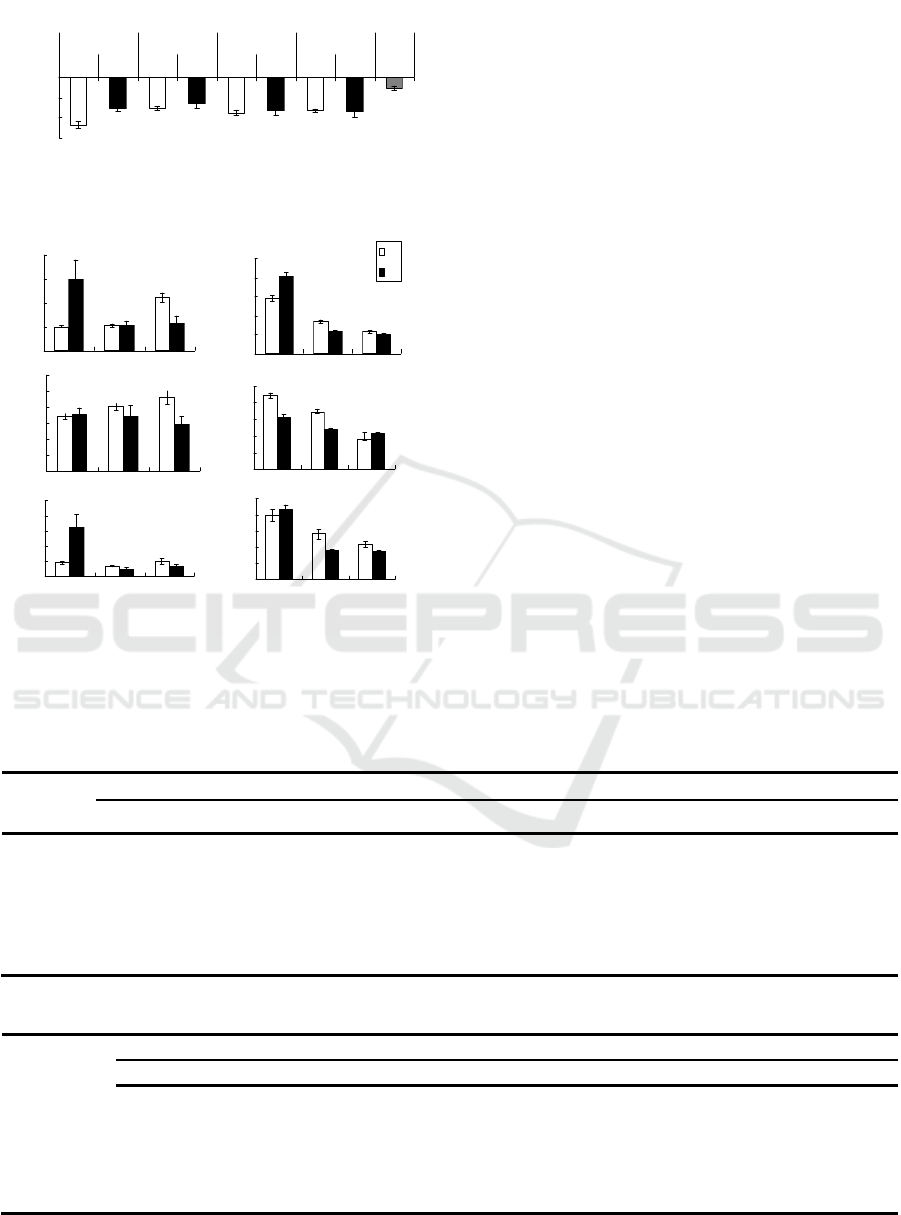
Figure 2: Carbon isotope content of soil and coal in the
grassland surrounding the W3 coal mine.
Figure 3: Contents of carbon, nitrogen, and sulfur of soil in
the grassland surrounding the W3 coal mines (A) and B3
coal mines (B).
Fig. 3 shows the carbon, nitrogen, and sulfur content
of the soil around the mining area. For 0–3 cm soil,
the soil total carbon and total sulfur content in the GD
area are substantially higher than that in the CK area,
while the total nitrogen of 10–20 cm soil in the CK
area was significantly higher than that in the GD area.
There was no significant difference between CK and
GD area in other soil layers.
3.2 Vegetation Traits of Grassland
Surrounding the Mining Area
The dominant species of climax community on
grassland surrounding W3 mining are Achnatherum
splendens, Stipa krylovii, and Stipa grandis. At the
same time, the GD area was dominated by
Neopallasia pectinata, Achnatherum splendens, and
Convolvulus ammannii (Table 1). Species also
changed to some extent. The important values of
Leymus chinensis and Stipa krylovii in the CK area
were higher than those in the GD area, indicating that
the community composition was unstable and in
succession (Table 2).
For the grass yield of the community (Table 3), the
grass yield in the CK area of the B3 mine was
significantly greater than that in the GD area. The
grass yield of the CK area in the W3 mine was greater
than that in the GD area (p=0.051). Compared with
the grass yield in the CK area, the grass yield of the
GD area decreased by 37.8% and 36.7% in the W3
mine and B3 mine, respectively.
Table 1: Dominant plant species in grassland surrounding the W3 coal mine.
Order CK area GD area
Latin name Important value Latin name Important value
1 Stipa krylovii 42.20 Neopallasia pectinata 17.93
2 Achnatherum splendens 18.05 Convolvulus ammannii 17.51
3 Stipa grandis 12.31 Stipa krylovii 17.41
4 Chenopodium aristatum. 9.86 Stipa grandis 16.95
5 Cleistogenes squarrosa 4.16 Agropyron mongolicum 16.73
Table 2: Dominant plant species in grassland surrounding the B3 coal mine.
Order CK area GD area
Latin name IV* Latin name IV
1 Leymus chinensis 46.90 Agropyron cristatum 21.90
2 Carex korshinskyi 15.47 Leymus chinensis 17.01
3 Artemisia sacrorum 18.71 leistogenes squarrosa 16.32
4 Phragmites australis 10.88 Carex korshinskyi 13.80
5 Iris lactea 9.84 Allium mongolicum 12.94
*IV means Important value
c
b
bb
b
bb
b
a
-23
-22
-21
-20
CK GD CK GD CK GD CK GD Coal
0-3 3-10 10-20 20-30 -
Treatments & depth(cm)
δ13C(‰)
b
b
b
b
b
a
0.00
0.05
0.10
0.15
0.20
0.25
0-3 3-10 10-20
Soil depth(cm)
S(% )
bc
ab
a
abc
abc
bc
0.0
0.1
0.1
0.2
0.2
0.3
0.3
N(%)
A
ab
b
b
b
b
a
0.0
2.0
4.0
6.0
8.0
03
310
10 20
C(%)
B
b
b
c
b
b
a
0
2
4
6
8
10
C
(
%
)
CK
GD
c
b
a
c
c
b
0.0
0.1
0.2
0.3
0.4
0.5
N(%)
a
b
bc
a
c
c
0.00
0.02
0.04
0.06
0.08
0.10
0-3 3-10 10-20
Soil depth(cm)
S(% )
Degradation of Grassland Covered by Coal Dust in a Temperate Steppe
55

Table 3: Changes in aboveground biomass (g) in grassland
surrounding the W3 and B3 coal mine.
Sites W3 B3
CK 162.11±18.01a* 93.63±13.22a
GD 100.85±23.67b 59.27±6.99b
* Letters indicate that the difference is significant at the 0.05 level.
The grassland cover of the GD area was lower than
that of the CK area (Table 4). Compared with the CK
area, the cover decreased by 33.6% and 32.9% in the
W3 mine and B3 mine, respectively.
Table 4: Changes in the cover of grassland surrounding the
W3 and B3 coal mine.
Sites W3 B3
CK 70.83%±4.43%a 45.33%±6.37%a
GD 46.75%±4.13%b 26.2%±3.69%b
4 DISCUSSIONS
4.1 Evaluation of Grassland Health
based on Vegetation Cover, Grass
Yield, and Soil Index of Grassland
around the Coal Mine
Based on data of grassland vegetation and soil around
the mine area, we evaluated the grassland health
status with reference to the Chinese standard of
natural grassland degradation(GB 19377 ‐ 2003,
2013). Table 5 lists the main indicators of the
standard.
Table 5: Classification and grading indicators of degradation level of natural grassland in China.
Determined Class of degradation and the relative percentage of reduction in each indicator
indexes No degradation Light degradation Medium degradation Heavy degradation
Grassland cover 0-10 11-20 21-30 >30
CAD# 0-10 11-20 21-40 >40
Grass yield 0-10 11-20 21-50 >50
0‒20cm SOM
†
0-10 11-20 21-40 >40
0‒20cm soil total N* 0-10 11-20 21-25 >25
#CAD means comprehensive arithmetic dominance of dominant species in grassland, CAD= (C’+P’)/2, Relative cover (C’) = the cover of a
species / the maximum cover of a species among the community. Relative weight (P') = the weight of a species / the maximum weight of a
species shoots in the community. †SOM means soil organic matter. *Soil nitrogen is a selective parameter. Other parameters are essential.
Based on the criteria in Table 5, the changes in
grassland–related indicators in coal mines are
evaluated. We found that the grassland surrounding
the two coal mines has moderate to heavy degradation
(Table 6, Table 7).
Table 6: Evaluation of grassland degradation based on the related indicators of grassland surrounding the W3 mine.
Monitoring index CK area
%
GD area
Reduction rate Degradation level
Total cover / % 70.80 46.8 34.00% heavy
CAD(S
.
krylovii) 1 0.47 52.82% heavy
Grass yield / g.m
-2
162.10 100.80 38.00% medium
3‒20cm SOM /g.kg
-1
17.63 11.87 32.68% medium
3‒20cm soil N/g.kg
-1
2.15 1.60 25.73% heavy
ISWEE 2022 - International Symposium on Water, Ecology and Environment
56

Table 7: Evaluation of grassland degradation surrounding the B3 coal mine.
Monitoring index CK area GD area Reduction rate Degradation level
Total cover / % 45.33% 26.20% 42.21% heavy
CAD(L. chinensis) 1 0.46 53.72% heavy
Grass yield / g.m
-2
93.63 59.27 36.70% medium
3-20cm SOM /g.kg
-1
15.34 11.87 22.62% medium
3-20cm soil N /g.kg
-1
2.59 2.27 12.36% light
The two coal mines were established almost at the
same time: the W3 mine (2007) and the B3 mine
(2006). The production capacity of the B3 coal mine
(140 million tons/year) was bigger than W3 coal mine
(6 million tons/year), so the emissions of pollutants
from W3 mine should be more than that of B3, which
may be one reason for the difference of reduced rate
of SOM and soil nitrogen content of the B3 and W3
coal mines. Although browning brown coal-derived
products can improve soil organic matter and promote
plant growth (Tahir et al., 2011), however, the
addition of lignite and a mixture of minerals with
lignite into the soil does not promote the growth of
alfalfa (Little, 2015). It is found that the soil data
changes less than the data of vegetation within one
coal mine (Table 6, Table 7). The increment of total
carbon content in the soil around the mining area
could attribute to high content of carbon in the coal
powder itself. At the same time, the increase in soil
sulfur content is also related to the deposition of coal
dust, because the sulfur content of the coal powder is
high at the W3 mine (Feng et al., 2005). Open pit
mines will produce a large number of air pollutants
(particle matter and SO
2
, NO
2
) as all the works related
to mining in the area sites near coal mining areas
(Mishra and Koshta, 2018). There was a lot of dust
and SO
2
emitted from the open-pit mines in this study,
which can fall over the leaf and inhibit the grass
growth (Wang et al., 2016; Wu, 2014). This may be
one of the essential factors contributing to grassland
degradation in this study.
4.2 Relationship between Grassland
Degradation and Coal Dust
Deposition, Soil Temperature, and
Moisture around the Coal Mine
The factors causing grassland degradation around the
coal mine may be related to the deposition of coal dust.
There was a lot of coal dust on the ground of grassland
in the GD area in this study. The coal dust falling on
the grass leaves would affect the photosynthesis of
plants. Studies have found that coal dust can reduce
the photosynthetic rate of African mangrove leaves
(Naidoo & Chirkoot, 2004). Our study also found that
the deposition of coal dust can reduce of
photosynthetic rate and the growth of several
herbaceous plants (Wang et al., 2016), which may be
a reason for the low grass yield in the GD area. In
addition, we sampled the leaves of several plants in
the GD area of the W3 coal mine and observed the
dust distribution on the leaves (Fig. 4). The leaves of
Leymus chinensis, Stipa grandis and Stipa krylovii
had a different amount of coal dust on their leaves.
The leaves of these plants were rough and had
epidermal hairs. These morphological structures
facilitate the retention of dust particles! The leaves of
Neopallasia pectinata was relatively small, and they
were needle-like with a smooth and hairless surface.
At the same time, the coal dust was only retained on
the hairy stem when observed under the microscope.
This may be the reason for the dominance of
Neopallasia pectinata in the GD area. Furthermore,
plants with low stature, rigid branches and leaves,
sunken stomata, smooth epicuticular wax or
pubescent leaves and branches were more likely to
accumulate dust (Turner, 2013). Meanwhile, some
studies found that plant in the arid region had a strong
resistance and adaption to dust stress (Matsuki et al.,
2016); However, the dust in this study is lignite
powder with a black color which is different from the
inert dust of some studies.
The deposition of lignite dust would influence soil
temperature and water content. In this study, the GD
grassland around B3 had a higher surface temperature
and lower soil water content (Table 8 and Figure 5).
In the same topographic condition, the difference of
soil temperature between the two areas was more than
5 °C, while the soil moisture in the topsoil of CK was
higher than that in the GD area (Fig. 5). This may be
caused by the coal dust deposition to the grassland
since the black dust on the ground is easy to absorb
more solar radiation, causing the ground temperature
to rise.
Degradation of Grassland Covered by Coal Dust in a Temperate Steppe
57
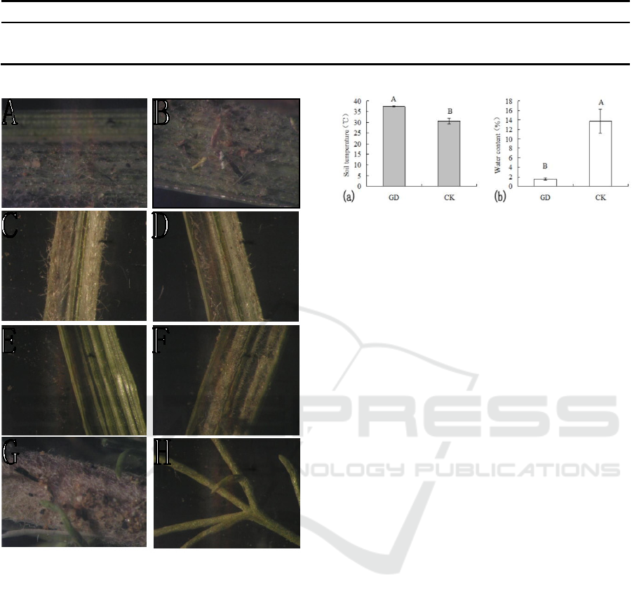
Table 8: Changes in soil water content of grassland surrounding theW3 coal mine.
Study area 0‒10 cm soil 10‒20 cm soil 20‒30 cm soil
CK-2015 4.51±0.28A* 5.40±0.32A 5.54±0.24A
GD-2015 2.84±0.28B 3.25±0.31B 3.71±0.47B
* Capital letters indicate that the difference is significant at the 0.001 level.
Figure 4: The dust covered on the leaf of dominant species
in the GD area surrounding the W3 coal mine (A,
B―Leymus chinensis; C, D―Stipa grandis; E, F―Stipa
krylovii; G, H―Neopallasia pectinata).
The evaporation of soil water accelerated, which was
easily led to soil drought. Plants are more susceptible
to drought stress, resulting in reduced biomass or the
death of certain species. Black coal powder is
different from inert silicon-containing dust, such as
white kaolin. Repeated application of a thin film of
inert dust (kaolin clay) increased crop yield (Glenn
and Puterka, 2005). Kaolin clay protects plants from
excess radiation resulting in reduced stomata
conductance and increased water use efficiency as it
is white.
Figure 5: Temperature (a) and water content (b) of soils in
the grassland surrounding the B3 coal mine.
5 CONCLUSIONS
In this study, we investigated the vegetation and soil
of grassland surrounding the coal mines in Inner
Mongolia steppe. After mining for 7 years, different
amounts of coal dust around the mine had been
accumulated. By comparing the soil and vegetation
status in the adjacent areas, we found that the
vegetation cover, aboveground biomass, important
values of dominant species, soil organic matter, and
total nitrogen decreased in the GD area, and the
species composition of the community changed. We
can conclude that the mining of lignite led to the
degradation of grasslands surrounding the coal mine.
we should pay attention to the controlling the
emission of gaseous pollutants such as dust and SO2
and protecting the grassland around the mining area.
ACKNOWLEDGEMENTS
We particularly appreciate the assistance in the
fieldwork by undergraduate students: Liang Wang,
Jing Li. This work was supported by the Opening
Project of the Key Laboratory of Road Traffic
Environmental Protection Technology,Ministry of
Transport,PRC.
REFERENCES
Bai, Z.K., Geng, H.Q., Guo, E. M. and Song L. (2006)
Several opinions of the coal mine exploitation and
ecological compensation, Environmental Protection,
(05A): 46-48. (In Chinese).
ISWEE 2022 - International Symposium on Water, Ecology and Environment
58

Beijing Huayu Engineering co., General Plan of Shengli
Mining Area in Xilin Gol League, Inner Mongolia
(updated version), Environmental Impact Report,
http://jz.docin.com/p-1254718103.html (Accessed
June 2015)
Bhattacharya, M., Rafiq, S. and Bhattacharya, S. (2015)
The role of technology on the dynamics of coal
consumption–economic growth: New evidence from
China, Applied Energy, (154): 686-695.
China geology survey, report of China Energy Resources,
http://www.cgs.gov.cn/ddztt/cgs100/bxcg/fwgj/20161
1 /P020161125577066113658.pdf(Accessed 25
November 2016)
Ejaz, S., Camer, G.A., Anwar, K. and Ashraf, M. (2014)
Monitoring impacts of air pollution: PIXE analysis and
histopathological modalities in evaluating relative risks
of elemental contamination, Ecotoxicology, (23)3: 357-
369.
FAO. 1991. World Soil Resources. An Explanatory Note
on the FAO World Soil Resources Map at 1:25,000,000
Scale. World Soil Resources Report 66, Rome, 61 pp.
Feng ,Y.J., Zhang, F.Y., Bao, B.H. [etc.], report of coal
exploration in the first mining area of west No. 2 open
pit mine in Shengli Coalfield, Xilinhot City, Inner
Mongolia Autonomous Region, (Accessed June 2005)
GB 19377-2003, G.A.o.Q.S., Inspection and Quarantine of
the People’s Republic of China. (2013) Parameters for
Degradation, Sandification and Salification of
Rangelands: National Standards of the People’s
Republic of China, Standards Press of China, Beijing
(In Chinese).
Geng, H.Q. (2008) The main environmental &social
problems in China‘s large coal mine construction,
Science, (60) 3: 33-37.
Glenn, D.M. and Puterka, G.J. (2005) Particle films: a new
technology for agriculture, Horticultural reviews, (31):
1-44.
Little, K.R. (2015) Commercial Lignite Coal-Derived
Amendments for Improved Pasture Growth and Soil
Health. Ph. D. Thesis, Monash University, Melbourne,
VIC, Australia.
Liao, H. and Wei, Y.M. (2011) Twelfth Five-Year Plan for
China's Energy and Carbon Emissions and Prospects,
Proceedings of the Chinese Academy of Sciences, (26)
2: 150-153
Li, Z.H., Pei, H., Liu, Z.L. and He, T. (1994) Study on the
restoration succession of degraded communities in
Leymus chinensis steppe. Journal of Inner Mongolia
University (Natural Science Edition). (25) 1: 88-98
Ma, J.J., Zhang, S.L.and Li, Q.F. (2006) The Intrusion Rule
of Wild Plant Species on Reclaimed Land of Heidaigou
Opencast Coal Mine and Effect to Ecosystem, Research
of Environmental Sciences, (19) 5: 101-106.
Matsuki, M., Gardener, M.R., Smith, A., Howard, R.K. and
Gove, A. (2016) Impacts of dust on plant health,
survivorship and plant communities in semi ‐ arid
environments, Austral Ecology, (41) 4: 417-427.
Mishra, S. and Koshta, M. (2018) Impact of coal mining on
ambient air: a case study of jamuna kotma coal mines
area. International Research Journal of Engineering
and Technology, (5) 5: 724-729.
Naidoo, G. and Chirkoot, D. (2004) The effects of coal dust
on photosynthetic performance of the mangrove,
Avicennia marina in Richards Bay, South Africa,
Environmental Pollution, (127) 3: 359-366.
Pandey, B., Agrawal, M. and Singh, S. (2014) Coal mining
activities change plant community structure due to air
pollution and soil degradation, Ecotoxicology,
(23)8:1474-1483.
Ratcliffe, D. (1974) Ecological effects of mineral
exploitation in the United Kingdom and their
significance to nature conservation, Proc. R. Soc. Lond.
A, (339)1618: 355-372.
Si, H., Bi, H., Li, X. and Yang, C. (2010) Environmental
evaluation for sustainable development of coal mining
in Qijiang, Western China, International Journal of
Coal Geology, (81) 3:163-168.
Spencer, S. and Tinnin, R. (1997) Effects of coal dust on
plant growth and species composition in an arid
environment, Journal of Arid Environments, (37) 3:
475-485.
Sun, H.L. et al (Eds.), (2000) China Resources Science
Encyclopedia, China Encyclopedia Press,Beijing.
Tahir, M., Khurshid, M., Khan, M., Abbasi, M. and Kazmi,
M. (2011) Lignite-derived humic acid effect on growth
of wheat plants in different soils, Pedosphere,
(21)1:124-131.
Turner, G.F. (2013) Vulnerability of vegetation to mining
dust at the Jack Hills, Western Australia. University of
Western Australia.
World-Coal-Association. (2014) Coal facts 2014, [online]
Statistic resources, World Coal Association, London.
https://www.worldcoal.org/file_validate.php?file=coal
_facts_2014(12_09_2014).pdf (Accessed 09 December
2014)
Wang, Z.Y., Hou, J., Guo, J.Y., Wang, C.J., and Wang, M.J.,
(2016) Coal dust reduce the rate of root growth and
photosynthesis of five plant species in inner Mongolian
grassland, Journal of Residuals Science & Technology,
(13)S1: 63-73.
Wu, X.X. (2014) The impact of sulfur dioxide emissions
from open pit mines in Xilinhot city on grassland
productivity, Master's thesis, Inner Mongolia
Technology University, Hohhot, China.
Xiao, X. (1997) Land cover classification of the Xilin River
basin, Inner Mongolia using Landsat imagery, Research
on Grassland Ecosystem (5): 240-252.
APPENDIX
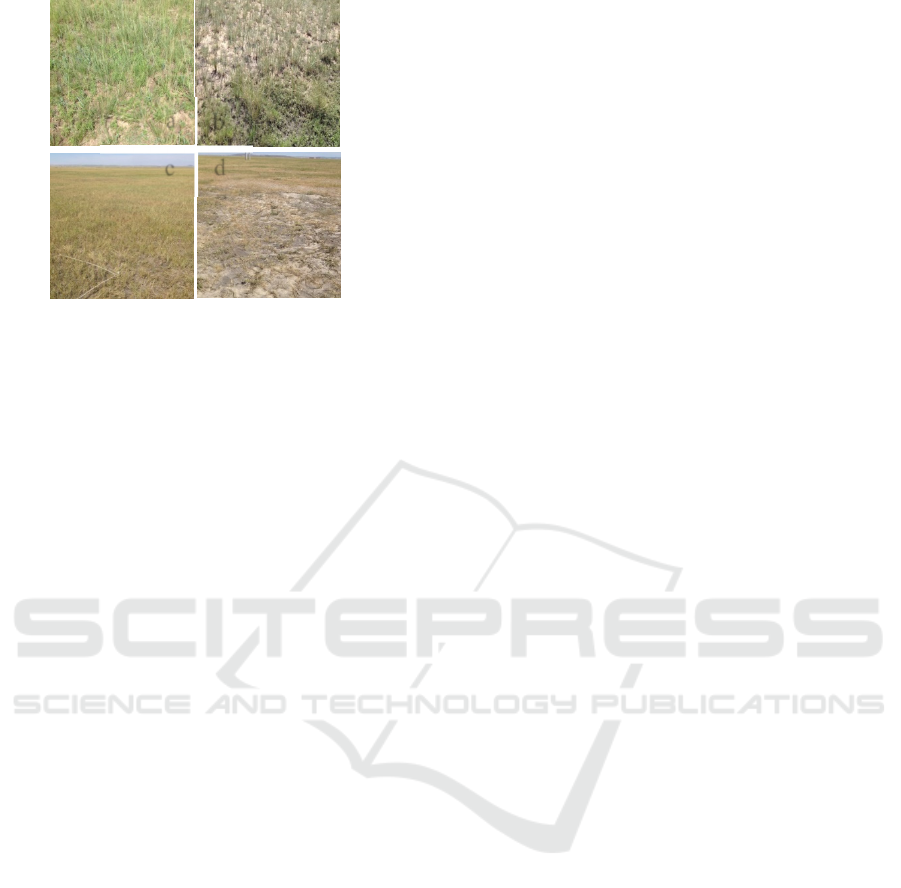
Figure S1: Photos of the grassland around the W3
and B3 coal mine showing CK area (a) and GD area
(b) in the W3 coal mine, CK area (c) and GD area (d)
in the B3 coal mine.
Degradation of Grassland Covered by Coal Dust in a Temperate Steppe
59
b
a
d
c
ISWEE 2022 - International Symposium on Water, Ecology and Environment
60
