
Water Body Extraction for the Landsat TM Imagery of Hulun Lake
Chunzhe Zhao
1,2
, Xueying Li
3
, Rong Xu
1,2,*
and Jiang Xiong
4
1
Key Laboratory of Intelligent Information Processing and Control of Chongqing Municipal Institutions of Higher
Education, Chongqing Three Gorges University, Wanzhou, Chongqing, China
2
Chongqing Engineering Research Center of Internet of Things and Intelligent Control Technology, Chongqing Three
Gorges University, Wanzhou, Chongqing, China
3
School of Computer Science and Engineering, Chongqing Three Gorges University, Wanzhou, Chongqing, China
4
School of Mathematics and Statistics, Chongqing Three Gorges University, Wanzhou, Chongqing, China
Keywords: Hulun Lake Wate, Reextraction, Ostu Algorithm, Cyclic Thresholding.
Abstract:
Based on the Landsat TM imagery, several common lake water extraction methods are compared via
extracting the Hulun Lake water body. The thresholds in these methods are determined by the Otsu and the
Iteration method. It is found that the water area in the image can be extracted using these methods, and the
application effects decrease in the order of NDWI, MNDWI, MIR, normal method of spectral relationship.
The thresholds determined by the Otsu and the Iteration method are almost equal. The thresholds from
Iteration method are more accurate, which means that these two algorithms are feasible in the identification
of the lake water body in this region.
*
Corresponding author.
1 INTRODUCTION
Since the 1970s, remote sensing technology has
been widely used in the extraction of water body
information due to its advantages of large
monitoring area, short imaging period, and
abundant information volume (Cao
et al., 2022).
Especially, the water body extraction is essential in
water resources survey, flood analysis, and
environmental monitoring. The accuracy of water
body extraction affects the quality of follow-up
surveys and assessments. Therefore, it is an
attractive topic to extract water bodies from remote
sensing images accurately and quickly (Dong et
al.,2022; Li et al.,2022).
Considering water accounts for 74% of the
Earth's surface, water condition differs under the
different geomorphological and hydrological
characteristics. Hence, several methods are
proposed for extracting water bodies (Anusha et
al.,2022; Ma et al.,2007; MaFeeters,1996;
McCormack et al.,2022; Lu et al.,2011; Soman and
Indu,2022). Zhang, Minghua combine the improved
spectral relationship method with the threshold
method to construct a multi-conditional spectral
relationship model, and used to extract information
on the water in the polar high mountains and
achieved good results (Zhang,2008). The decision
tree is employed in the automatic extraction of the
water body (Du et al., 2001; Li and Wang, 2007).
Hu, Zhengguang et al. proposes the algorithm based
on the AVHRR data combined with the
double-boundary extraction and the decomposing of
the mixed pixels (Hu et al.,2007). The high
accuracy and feasibility of the algorithm is verified
in monitoring the lake area changes in northeast of
China and Inner Mongolia. Xu, Hanqiu and Cao,
Ronglong optimize and improve NDWI separately
(Xu, 2006; Cao et al., 2008). Both of them increase
the accuracy of water extraction. Although the
information extraction methods of water body
mainly include single-band threshold method,
exponential model method, normal method of
spectral relationship, image classification method,
and so on, the index method of water body and the
normal method of spectral relationship are widely
used for water body extraction since their high
precision.
The extraction information of lake water body is
the basis for the dynamic monitoring of lakes.
354
Zhao, C., Li, X., Xu, R. and Xiong, J.
Water Body Extraction for the Landsat TM Imagery of Hulun Lake.
DOI: 10.5220/0011927800003612
In Proceedings of the 3rd International Symposium on Automation, Information and Computing (ISAIC 2022), pages 354-359
ISBN: 978-989-758-622-4; ISSN: 2975-9463
Copyright
c
2023 by SCITEPRESS – Science and Technology Publications, Lda. Under CC license (CC BY-NC-ND 4.0)
However, due to the complex interaction process
among lake water bodies, surrounding land objects,
solar radiation, and the atmosphere, the presence of
mixed pixels has caused by the multiple
interference of mountain shadows and other noises,
which makes the extraction difficulty and
uncertainty of lake water body increased (Xu et
al.,2021). Previous studies have shown that most
methods of water extraction have certain regional
limitations, such as: the method applied to a certain
lake may not be suitable for another lake, and the
size of the threshold in the water extraction model
has different effects on the extraction results (Sarp
and Ozcelik,2017). The thresholds in the existing
studies are mostly determined based on experience
through repeated human-computer interaction tests,
and are rarely determined using a threshold
algorithm for image segmentation. The effects of
different threshold algorithms on water extraction
results are also rarely analysed.
In this study, Landsat TM is used as the data
source, and several common water extraction
methods are used to extract the water information of
the Hulun Lake. This paper compares and analyses
the impact of different threshold algorithms on
water extraction results, and supports improving the
automation of water body information recognition.
2 RESEARCH AREA AND ITS
DATA
Hulun Lake (48°30′-49°20′N and 116°58′-117°48′E)
lies in the southern suburb of Manzhouli City,
Hulunbeier League. Its location is between
Xinbarhuzuoqi and Xinbaerhuyouqi, and the lake
area belongs to the temperate semi-arid climate
zone. The source of the lake water mainly depends
on the surface runoff and the atmospheric
precipitation. The rivers are flowing into Hulun
Lake are mostly seasonal rivers. The main rivers
into the lake are the Krulun River in the southwest
and the Wuerxun River in the southeast.
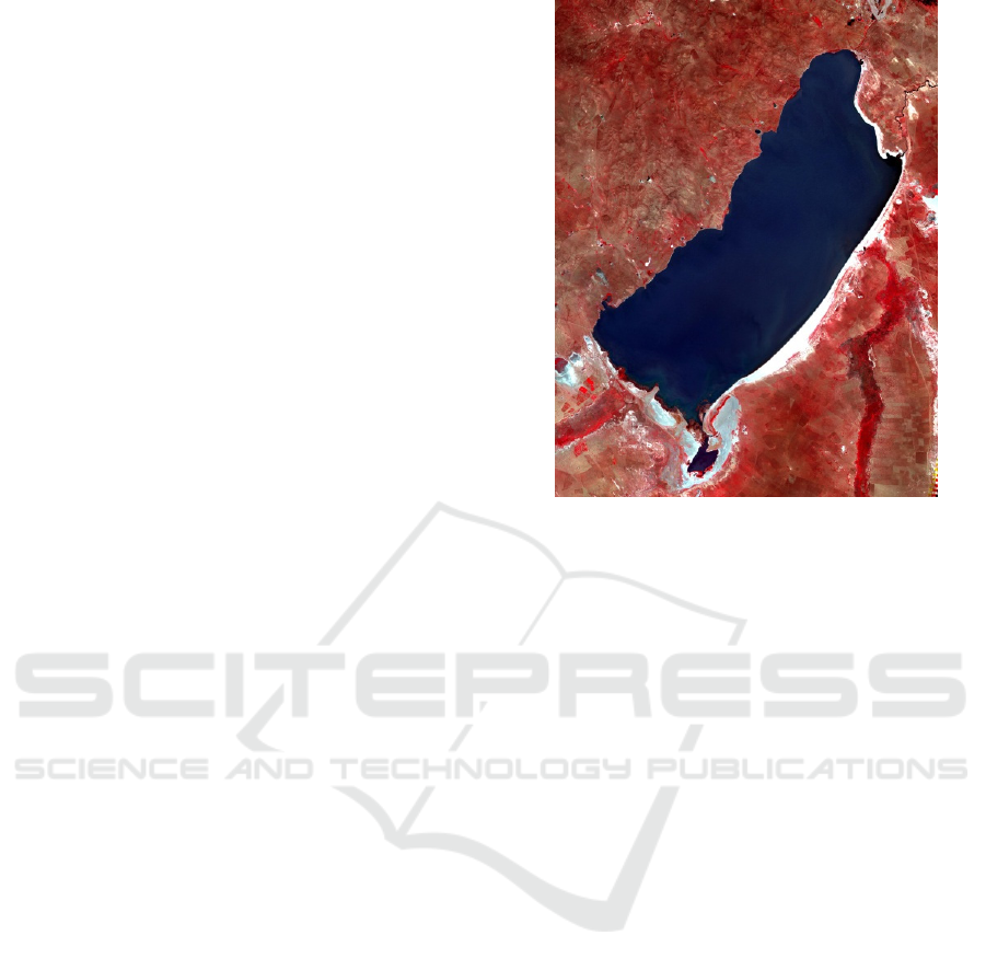
The experimental data has taken from the
Landsat TM image of September 7, 2010, with a
landscape number of 125-26. The product is
Level1T, it has been subjected to system radiation
correction, ground control point geometry
correction, and DEM terrain correction, including 7
bands of data. Data pre-processing is mainly image
cropping..
Figure 1: Landsat TM image.
3 LAKE WATER INFORMATION
EXTRACTION METHOD
To extract the water body of the Hulun Lake,
several common water extraction methods are
employed, such like single-band threshold method,
normal method of spectral relationship and
exponential model method. The threshold required
in the above method has determined by a threshold
algorithm.
3.1 Water Extraction Method
Based on the single-band threshold method, the
water body has a low reflectance in the near
infrared and short wave infrared bands, and it has
easily distinguished from other features. For this
feature, a threshold K can be determined in the TM5
band, the water body is smaller than the threshold,
and other features are larger than the threshold.The
extraction model of water body is as follows.
TM5<K . (1)
With the normal method of spectral relationship,
Zhou, Chenghu et al. analyse the spectral
characteristics of ETM+ images. It is found that
water has the spectral relationship between
TM2+TM3 and TM4+TM5. This feature can be
Water Body Extraction for the Landsat TM Imagery of Hulun Lake
355

used to extract water information (Zhou et al.,
1999). The extraction model of water body is.
TM2+TM3 TM4+TM5 >0(
)-
(
)
.
(2)
Besides, there are many index models for water
extraction, such as the Normalized Difference
Water Index (NDWI), the Modified Normalized
Difference Water Index (MNDWI), and
Normalized Difference Vegetation Index (NDVI).
In this study, the formula of NDWI and MNDWI
are expressed by:
NDWI=(TM2-TM4)/(TM2+TM4), (3)
MNDWI=(TM2-TM5)/(TM2+TM5). (4)
Based on the contrast between the green and
near-infrared bands, NDWI can suppress
vegetation information to the maximum extent to
achieve the purpose of highlighting water
information (
McFeeters,1996). MNDWI is an
improvement to MDWI that better suppresses
building information and improves the accuracy
of water extraction. The MNDWI and NDWI
values of the water body are higher than other
ground objects, so the water body information
can have extracted by setting the corresponding
thresholds for the two indexes. The water
extraction models are
N
DWI>M , (5)
MNDWI>N , (6)
where M and N are threshold values.
3.2 Threshold Algorithm
In order to compare the applicability of different
threshold algorithms, the Ostu method and the
Iteration method are employed.
The Ostu method is based on the separability
of the target and background categories in the
image. The basic principle is to divide the grey
histogram of the image into two parts with the
optimal threshold, such that the inter-class
variance between the two parts achieves the
maximum value. That is the maximized
separation. The Ostu algorithm is expressed as
follows.
a. Read the grayscale image.
b. Let k=0, and t(0) be the smallest grayscale value.
c. Divide the image into Class C
o
and C
b
based on t(k).
d. Calculate the possibility, the mean value and the
variance of Class C
o
and C
b
.
e. Calculate the inter-class variance between of Class
C
o
and C
b
.
f. Let t(k+1)=t(k)+0.005, k=k+1.
g. Repeat Step c-f until t(k) exceeds the largest
grayscale value.
h. Find the largest inter-class variance, and the
corresponding t(k) is the threshold.
The Iteration algorithm is a method of selecting an
appropriate threshold in the image segmentation
process, also known as the cyclic threshold
method. It is based on the approximation of the
idea of threshold iteration, using the program to
calculate the appropriate segmentation threshold
automatically. The guideline of the Iteration
algorithm is as follows.
a. Read the grayscale image, then find the smallest
grayscale value t
min
and the largest grayscale value
t
max
.
b. Let k=0 and t(0)=(t
min
+t
max
)/2.
c. Divide the image into Class C
o
and C
b
based on t(k).
d. Let t
o
be the mean value Class C
o
, and t
b
be the
mean value Class C
b
.
e. Let t(k+1)=(t
o
+t
b
)/2 and k=k+1.
g. Repeat Step c-e until |t(k)-t(k-1)|<0.005.
h. The last t(k) is the threshold.
According to the former guidelines, the Ostu
method and the Iteration method are implemented.
For the Ostu method, the threshold initial value t(0)
takes the minimum gray value T
min
of the image and
increments by 0.005 steps each time until t(k) is
greater than or equal to the maximum gray value
T
max
of the image; A t(k) divides the pixels on the
image into two categories. After calculating the
variance between the classes in turn, the t (k) when
the variance between the classes is the largest has
taken as the optimal threshold. In the Iteration
method, we first find out the minimum grey value
T
min
and the maximum grey value T
max
in the image.
We can set the average value to T(0), divide the
pixels into two categories according to T(0), and
calculate the two average grey values of the class
pixel, and then the average of the current two
average grey values is used as the next threshold,
and the process is repeated until T(k+1)-T(k)<0.005
ends. T(k+1) at this time is the optimal threshold.
The normal method of spectral relationship
(formula (2)) does not need to set a threshold value,
and the difference image formed by
(TM2+TM3)-(TM4+TM5) has binarized to obtain a
water body extraction result. For the single-band
threshold method, two thresholds of the TM5 band
have obtained by the Ostu method and the Iteration
method, so that there are extraction results of water
body. The exponential model method needs to obtain
NDWI and MNDWI images based on TM images,
and then apply the Ostu method and Iteration
method to calculate the threshold values, and obtain
four extraction results of water body.
ISAIC 2022 - International Symposium on Automation, Information and Computing
356
4 WATER EXTRACTION
RESULTS AND ACCURACY
ANALYSIS
On the TM composite pseudo-colour image, the
water body is blue-black and the vegetation is
bright red or light red. The Visual Image
Interpretation has used to delineate the Hulun
Lake boundary as a reference data for testing the
water extraction results of each method. In order
to scientifically and objectively evaluate the
experimental results of various methods for
extracting water body information, this paper
qualitatively and quantitatively evaluates the
water body extraction results from two aspects:
visual effect and area precision.
4.1 Water Extraction Results
Since the thresholds obtained by the Ostu method
and the Iteration method are relatively close, this
paper only evaluates the visual effects of the water
extraction results obtained by the former.
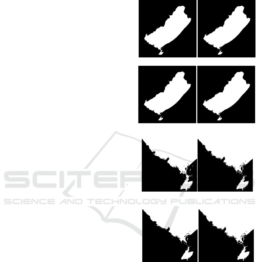
Figure 2 shows the results of water extraction by
each method, and Figure 3 is a partial enlarged view
of Figure 2, which is showing the results of water
extraction on the south bank of the lake. Referring to
the TM composite pseudo-colour image, the
shoreline of the east, west, and north shores of Hulun
Lake extracted by the single-band threshold method
is basically the same as the Visual Image
Interpretation, but some of the shoals on the south
bank are misunderstood, and there is a large
misplacement phenomenon. The extraction result of
this method is less than ideal, which has related to
the threshold setting on the one hand and the
principle of the method on the other hand. The
results of the inter-spectral relationship extraction
method are more accurate than the single-band
threshold method, and there are fewer shoals, which
have mentioned mistakenly. The results of NDWI
and MNDWI extraction are relatively close. The
latter have more shoals, but the rivers in the south
eastern shore have extracted well.
In general, the former methods have achieved
good results in the obvious east, west and north
shores of the water and land boundaries, but the
extraction effect on the south bank (Figure 3) is poor,
mainly due to the wrong shoal and some high water
content. The vegetation area, which also reflects the
lower threshold (high) determined by the threshold
algorithm.
Figure 2: Water extraction results of each method.
Figure 3: Water body extraction results on the south bank
of the lake.
4.2 Accuracy Evaluation
The accuracy of the lake surface area obtained by
each method has calculated based on the visually
interpreted lake area (Table 1). Among them, the
area of the three-band threshold method, NDWI and
MNDWI is the area when the threshold has
determined by the Ostu method. It can be seen that
the accuracy of the area obtained by several methods
is high, and the order of the area accuracy from high
to low is NDWI, MNDWI, normal method of
Water Body Extraction for the Landsat TM Imagery of Hulun Lake
357

spectral relationship, single-band threshold method.
This has consistent with the results of the visual
evaluation. At the same time, it has found that the
NDWI and MNDWI index models can achieve
better results, when the threshold has determined by
the automatic thresholding algorithm.
Table 2 shows the thresholds calculated by the
Ostu method and Iteration method. It can be seen
that for the single-band threshold method, the results
obtained by the two threshold algorithms are almost
identical; for the two index models NDWI and
MNDWI, the difference between the two threshold
algorithms is smaller, and the threshold obtained by
the Iteration method is more accurate. However, it
should have noted that some above extraction
methods of water body have mistakenly mentioned a
part of the non-water body, and it can be seen that
the threshold obtained by the automatic thresholding
algorithm is low (high).
Table 1: Comparison of water extraction results of each
method.
Method
Area
(km
2
)
Reference
area(km
2
)
Area
accuracy
/%
Single band
threshold
1800.95 1772.15 98.37
Inter-spectral
relationshi
p
1781.13
1772.15
99.49
NDWI 1775.12
1772.15
99.83
MNDWI 1779.23
1772.15
99.60
Table 2: Threshold calculation results.
Method
Maximum interclass
variance method
Iteration
method
Single band
threshold
57 56
NDWI 0.020 0.025
MNDWI 0.080 0.086
5 CONCLUSIONS
For the Hulun Lake, the NDWI and MNDWI
extraction results are better, if the threshold value of
water body extraction is determined by the automatic
thresholding algorithm. The area of the lake has
interpreted visually, and its area accuracy is above
99%. The single-band threshold method is relatively
poor. The reason is related to the threshold algorithm.
On the other hand, the reason is that it has a great
relationship with the principle of the method; the
results have extracted by the normal method of
spectral relationship, which are between the
single-band method and the exponential model
method, and the accuracy is high.
In this paper, the lake area extracted by various
methods has evaluated quantitatively with the area as
a reference index, and the positioning accuracy of
each extraction result will have evaluated in the
future. In addition, the threshold value obtained by
the automatic thresholding algorithm in the study
area is different from the artificially extraction
threshold set of water body in other areas. The
reason for further study has needed, and the result
may help to improve the accuracy of the threshold
algorithm.
ACKNOWLEDGEMENTS
This research is supported by the Scientific and
Technological Research Program of Chongqing
Municipal Education Commission (Grant No.
KJQN202001233), the Natural Science Foundation
of Chongqing, China (Grant No.
cstc2018jcyjAX0725), the Key Laboratory of
Chongqing Municipal Institutions of Higher
Education (Grant No. [2017]3), and the Program of
Chongqing Development and Reform Commission
(Grant No. 2017[1007]).
REFERENCES
Anusha, B.N., Babu, K. R., Kumar, B. P., Kumar, P. R.,
and Rajasekhar, M.(2022). Geospatial approaches for
monitoring and mapping of water resources in
semi-arid regions of Southern India, Environmental
challenges, 8:100569.
Cao, H., Han, L., and Li, L. (2022). Changes in extent of
open-surface water bodies in china's yellow river basin
(2000-2020) using google earth engine cloud platform.
Anthropocene, 39: 100346.
Cao, R. L., Li, C. J., Liu, L. Y., Wang, J. H., and Yan, G. J.
(2008). Extracting miyun reservoir’s water area and
monitoring its change based on a revised normalized
different water index. Science of surveying and
mapping, 33(2):158-160.
Dong, Y. T., Fan, L. B., Zhao, J., Huang, S. S., Geiß, C.,
Wang, L. Z., and Taubenbock, H. (2022). Mapping of
small water bodies with integrated spatial information
for time series images of optical remote sensing.
Journal of hydrology, 614(Part B):128580.
Du, J. K., Huang, Y. S., Feng, X. Z., and Wang, Z. L.
(2001). Study on water bodies extraction and
classification from spot image. Journal of remote
ISAIC 2022 - International Symposium on Automation, Information and Computing
358

sensing, 5(3):214-219.
Hu, Z. G., Wang, Y. T., Chi, T. H., Liu, S. H., and Bi, J. T.
(2007). Monitoring lake areas based on mixed pixel
decomposition combined with double-edge extraction.
Remote sensing information, (3):34-38.
Li, K., and Wang, Y. Y. (2007). Study on the modified
automatic water bodies extraction model from tm
image. Journal of water resources & water engineering,
18(6):20-22.
Li, Y. S., Dang, B., Zhang, Y. J., and Du, Z. H. (2022).
Water body classification from high-resolution optical
remote sensing imagery: Achievements and
perspectives. ISPRS journal of photogrammetry and
remote sensing, 187:306-327.
Lu, S. L., Wu, B. F., Yan, N. N., and Wang, H.
(2011).Water body mapping method with HJ-1A/B
satellite imagery. International journal of applied earth
observation and geoinformation, 13:428-434.
Ma, M., Wang, X., Veroustraete, F., and Dong, L. (2007).
Change in area of ebinur lake during the 1998-2005
period. International journal of remote sensing, 28:(24),
5523 -5533.
McCormack, T., Campany, J., and Naughton, O. (2022). A
methodology for mapping annual flood extent using
multi-temporal Sentinel-1 imagery, Remote Sensing of
Environment, 282:113273.
McFeeters, S. K. (1996). The use of the normalized
difference water index in the delineation of open water
features. International journal of remote sensing, 1996,
17:1425-1432.
Sarp, G., and Ozcelik, M. (2017). Water body extraction
and change detection using time series: A case study of
Lake Burdur. Turkey, Journal of Taibah University for
science, 11(3):381-391.
Soman, M. K., and Indu, J. (2022). Sentinel-1 based Inland
water dynamics mapping system. Environmental
modelling & software, 149:105305.
Xu, H. Q. (2006). Modification of normalized difference
water index to enhance open water feature in remotely
sensed imagery. International journal of remote
sensing, 27(14):3025-3033.
Xu, Y. Y., Lin, J., Zhao, J. W., and Zhu, X.Y. (2021). New
method improves extraction accuracy of lake water
bodies in Central Asia. Journal of hydrology, 603 (Part
D): 127180.
Zhang, M. H. (2008). Extracting water-body information
with improved model of spectral relationship in a
higher mountain area. Geography and geo-information
science, 24(2): 14-16.
Zhou, C. H., Luo, J. C., Yang, X. M., Yang, C. J., and Liu,
Q. S. (1999). Understanding and analysis of remote
sensing imagery. Beijing: Science Press.
Water Body Extraction for the Landsat TM Imagery of Hulun Lake
359
